
NATIONAL
SENIOR CERTIFICATE
GRADE 12
JUNE 2023
GEOGRAPHY
MARKING GUIDELINE
MARKS: 150
This marking guideline consists of 8 pages.
You're offline
Skip to contentMemorandum %20June%202024%20Possible%20Answers_hlayiso.com_--7e728632-059d-401a-ba75-fd45632f6091/v1-269fb55ac60eebf555e6/card.webp)
View all
GEOGRAPHY GR12 MEMO JUNE 2023_English_hlayiso.com_.pdf
Geography · Grade 12 · Eastern Cape June Exam · 2023 · English. Memorandum, 8 pages. Read online or download the PDF.
- Subject
- Geography
- Grade
- Grade 12
- Language
- English
- Document type
- Memorandum
- Year
- 2023
- Exam period
- Eastern Cape June Exam
- Pages
- 8
- File size
- 384.3 KB
Loading document…
Loading document…
1 of 8
Document textSearch extracted text and jump to a page.
2 GEOGRAPHY (EC/JUNE 2023)
QUESTION 1: WEATHER AND CLIMATOLOGY
1.1 1.1.1 Z (1)
1.1.2 Y (1)
1.1.3 Y (1)
1.1.4 Z (1)
1.1.5 Y (1) (5 x 1) (5)
1.2 1.2.1 B (1)
1.2.2 D (1)
1.2.3 C (1)
1.2.4 A (1)
1.2.5 D (1) (5 x 1) (5)
1.3 1.3.1 Northern (1) (1 x 1) (1)
1.3.2 A – Mature (1) (1 x 1) (1)
1.3.3 A (1) (1 x 1) (1)
1.3.4 Fully developed eye (1) (1 x 2) (2)
1.3.5 (a) Eye – descending air dominates (1)
Eye wall – Rising air dominates (1) (2 x 1) (2)
(b) Eye – Descending air
Clear, cloudless skies due to descending air causing moisture
to evaporate (2)
Little to no wind because of weak pressure gradient (2)
Higher temperatures because descending air compresses and
heats up (2)
No rainfall due to lack of moisture (2)
Eye wall – Rising air
Strong rising air cause cumulonimbus clouds to develop (2)
Pressure gradient is strong and hurricane strength winds
prevail (2)
Leading left quadrant associated with extremely strong winds
due to a combination of rotation and forward movement of the
system (2)
Latent heat drives the system (2)
Heavy rainfall due to evaporation over warm waters (2)
[Any FOUR – BOTH THE EYE AND EYE WALL MUST BE
MENTIONED] (4 x 2) (8)
Copyright reserved Please turn over
(EC/JUNE 2023) GEOGRAPHY 3
1.4 1.4.1 Peak temperatures of 43,9 °C (1)
Berg wind conditions (1) (2 x 1) (2)
1.4.2 It heats up adiabatically. (2) (1 x 2) (2)
1.4.3 Between 35 – 40 min / Less than an hour (2)
[Any ONE] (1 x 2) (2)
1.4.4 Anticlockwise circulation of air from the Kalahari High descends
down the escarpment. (2) (1 x 2) (2)
1.4.5
(1)
(1)
(1)
(3 x 1) (3)
1.4.6 Moisture will be evaporated from the soil and vegetation (2)
Increases the danger of veldt fires (2)
Decreased humidity (2)
[Any TWO] (2 x 2) (4)
[40]
Copyright reserved Please turn over
4 GEOGRAPHY (EC/JUNE 2023)
QUESTION 2: GEOMORPHOLOGY
2.1 2.1.1 Z (1)
2.1.2 Y (1)
2.1.3 Z (1)
2.1.4 Y (1)
2.1.5 Y (1) (5 x 1) (5)
2.2 2.2.1 A (1)
2.2.2 D (1)
2.2.3 B (1)
2.2.4 C (1)
2.2.5 B (1) (5 x 1) (5)
2.3 2.3.1 Longitudinal (1)
Cross/Transverse profile (1) (2 x 1) (2)
2.3.2 Profile A – V-shaped (1)
Profile B – U-shaped (1) (2 x 1) (2)
2.3.3 At profile A erosion is mainly vertical/downward (2)
At profile B the erosion is mainly lateral/sideways (2) (2 x 2) (4)
2.3.4 (a) Ungraded (1) (1 x 1) (1)
(b) The lake is temporarily preventing further erosion; however
erosion will eventually take place over time (2) (1 x 2) (2)
(c) At X:
Erosion dominates due to various knickpoints (2)
The rivers are under graded therefore more erosion (2)
[Any ONE] (1 x 2) (2)
At Y:
The lower course is characterised by deposition, hence there
is a balance between erosion and deposition (2)
The river is over graded because deposition dominates (2)
[Any ONE] (1 x 2) (2)
Copyright reserved Please turn over
(EC/JUNE 2023) GEOGRAPHY 5
2.4 2.4.1 When a more energetic stream/river captures the head waters of
a less energetic stream/river (2)
[CONCEPT] (1 x 2) (2)
2.4.2 (a) A (1)
(b) D (1) (2 x 1) (2)
2.4.3 Knickpoint waterfall (1) (1 x 1) (1)
2.4.4 Gorges are tourist attractions (2)
Transport routes through gorges reduces transport costs (2)
[Any ONE] (1 x 2) (2)
2.4.5 The river at A is stronger due to steeper gradient, higher volume
of water and flows over softer rock (2)
River is lower on the watershed (2)
Therefore, river A has more energy than river at D (2)
River A is lengthening its course through headward erosion (2)
Headward erosion causes the river to cut through the
watershed (2)
River A captures the waters of river B
This capture takes place at the elbow of capture (2)
[Any FOUR] (4 x 2) (8)
[40]
QUESTION 3: SETTLEMENTS
3.1 3.1.1 counter urbanisation (1)
3.1.2 urban growth (1)
3.1.3 level (1)
3.1.4 Junction (1)
3.1.5 B (1) (5 x 1) (5)
3.2 3.2.1 Z (1)
3.2.2 Y (1)
3.2.3 Y (1)
3.2.4 Z (1)
3.2.5 Z (1) (5 x 1) (5)
3.3 3.3.1 Vacant land bought by the state and making it available for
previously disadvantaged people (2)
[CONCEPT] (1 x 2) (2)
Copyright reserved Please turn over
6 GEOGRAPHY (EC/JUNE 2023)
3.3.2 Land restitution (1)
Land tenure (1)
[Any ONE] (1 x 1) (1)
3.3.3 Enhance private sector participation (1)
Enabling policies (1)
Monitoring mechanisms by the state (1)
[Any TWO] (2 x 1) (2)
3.3.4 To improve agricultural growth (2)
To make sure farmers have the facilities to sustain farming (2)
To make sure farmers are successful and contribute to economic
growth (2)
To provide knowledge and skills assistance (2)
[Any ONE] (1 x 2) (2)
3.3.5 Apartheid policies of the past prevented non-whites to own land in
South Africa (2)
Non-whites were disposed of their land (2)
Corruption and ineffective handling of land reform processes (2)
Land reform programmes provided little assistance and benefit for
the previously disadvantaged (2)
Service delivery by local municipalities is poor (2)
[Any FOUR] (4 x 2) (8)
3.4 3.4.1 CBD (1) (1 x 1) (1)
3.4.2 Most accessible (1)
Highest buildings (1)
Usually grid-iron street pattern (1)
Traffic congestion (1)
Highest land values (1)
High pollution levels (accept examples) (1)
[Any TWO] (2 x 1) (2)
3.4.3 Provides an alternative route to bypass the CBD (2) (1 x 2) (2)
3.4.4 Buildings are dilapidated and in poor condition (2)
Graffiti on walls (2)
[Any ONE] (1 x 2) (2)
3.4.5 The buildings are dilapidated and in poor condition, yet the land
values are high (2) (1 x 2) (2)
3.4.6 On the outskirts/rural-urban fringe because the land values are low
(2)
Abundance of space available for future expansion (2)
Near the coal mine, which reduces transport costs (2)
The nearby river provides water for cooling purposes (2)
Dominant easterly winds are blowing the smoke/polluted air away
from most of the buildings/households (2)
[Any THREE] (3 x 2) (6)
[40]
Copyright reserved Please turn over
(EC/JUNE 2023) GEOGRAPHY 7
QUESTION 4: CALCULATIONS AND MAP SKILLS
4.1 4.1.1 B (1 x 1) (1)
4.1.2 (a) 187° (2) (1 x 2) (2)
(b) 187°00'
+ (1) 24°36'
211°36' WTN (1) (2 x 1) (2)
(c) Magnetic bearing includes the annual change (1)
Magnetic bearing includes the magnetic declination, which
considers the movement of tectonic plates (1)
[Any ONE] (1 x 1) (1)
4.1.3 (a) 1 502 – 1 240 = 262 m (1) (1 x 1) (1)
(b) 6,7(1) cm x 100 = 670 m (1) (2 x 1) (2)
(c) Contour lines are close to one another (1) (1 x 1) (1)
4.2 4.2.1 C (1) (1 x 1) (1)
4.2.2 D (1) (1 x 1) (1)
4.2.3 A (1) (1 x 1) (1)
4.2.4 (a) Aspect (1) (1 x 1) (1)
(b) Receives direct rays of the sun / it is situated in the warm
thermal belt (2)
Away from the cold valley bottom (2)
Area is protected against strong winds from the crest (2)
[Any ONE] (1 x 2) (2)
4.2.5 (a) Upper course (1) (1 x 1) (1)
(b) V-shaped valleys (1)
Contour lines close to one another/Steep slopes (1)
Source of the river is evident (1)
[Any ONE] (1 x 1) (1)
Copyright reserved Please turn over
8 GEOGRAPHY (EC/JUNE 2023)
4.2.6 (a) Irregular (1)) (1 x 1) (1)
(b) Less traffic congestion (1)
Not so monotonous (1)
[Any ONE] (1 x 1) (1)
(c) The area is reasonably flat / Slopes are gentle (2) (1 x 2) (2)
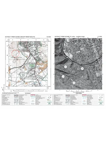
4.3.1 Orthophoto map (1) (1 x 1) (1)
4.3.2 Real-life features can be observed (1)
First-hand information (1)
Very little manipulation (1)
[Any ONE] (1 x 1) (1)
4.3.3 (a) Erosion (1) (1 x 1) (1)
(b) Polygon (1) (1 x 1) (1)
(c) The exact location can be identified (2)
The area being influenced can be determined (2)
[Any ONE] (1 x 2) (2)
(d) The area would be restricted, which will give it time
to repair (2)
(1 x 2) (2)
[30]
TOTAL: 150
Copyright reserved Please turn over
Recommended for this subject
Published documents with matching subject and grade metadata.
Memorandum
Geography-Grade-12-NSC-MEMO-P1-May-June-2025-Free-State.pdf
Memorandum
Gr 12 Geography (English) June 2024 Possible Answers_hlayiso.com_.pdf
Memorandum
2023 MP June Memo_hlayiso.com_.pdf
Memorandum
2023 WC Prelim P1 Memo_hlayiso.com_.pdf
Memorandum
GEOGRAPHY P2 GR12 MEMO SEPT2022 English final_hlayiso.com_.pdf
Memorandum
2022 KZN June Memo_hlayiso.com_.pdf
Related documents
Matched using subject, grade, language, document type and exam metadata.
Question paper
Geography P1 (English) QP_hlayiso.com_.pdf
Memorandum
GEOGRAPHY P2 MEMO GR12 SEPT 2020 English_hlayiso.com_.pdf
Memorandum
GEOGRAPHY P1 GR12 MEMO SEPT2018 English_hlayiso.com_.pdf
Memorandum
GEOGRAPHY P2 GR12 MEMO SEPT2018 English_hlayiso.com_.pdf
Memorandum
Geography P1 Memo June 2018 English_hlayiso.com_.pdf
Memorandum
GEOGRAPHY P1 GR12 MEMO SEPT2017 English_hlayiso.com_.pdf
More from Grade 12 Geography
Explore more published documents in this catalogue.
Question paper
Geography-Grade-12-NSC-P2-QP-September-2025-KZN.pdf
Question paper
Geography P1 May-June 2025 Eng.pdf
Question paper
HARTBEESPOORT DAM1 D FINAL.pdf
Question paper
2023 KZN Prelim P2 QP_hlayiso.com_.pdf
Question paper
3224BC_GRAAFF_REINET_A3 Deb_hlayiso.com_.pdf
Question paper