
Downloaded from hlayiso.com
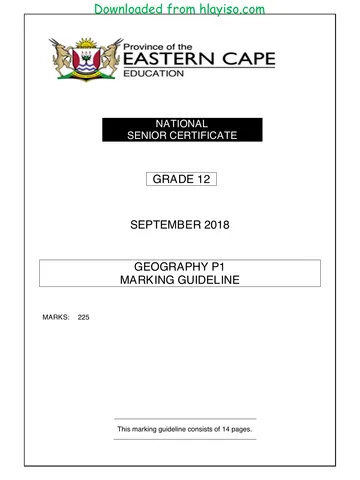
NATIONAL
SENIOR CERTIFICATE
GRADE 12
SEPTEMBER 2018
GEOGRAPHY P2
MARKING GUIDELINE
MARKS: 75
This marking guideline consists of 11 pages.
You're offline
Skip to contentMemorandum %20June%202024%20Possible%20Answers_hlayiso.com_--7e728632-059d-401a-ba75-fd45632f6091/v1-269fb55ac60eebf555e6/card.webp)
View all
GEOGRAPHY P2 GR12 MEMO SEPT2018 English_hlayiso.com_.pdf
Geography · Grade 12 · Eastern Cape Mock Exam · 2018 · English. Memorandum, 11 pages. Read online or download the PDF.
- Subject
- Geography
- Grade
- Grade 12
- Language
- English
- Document type
- Memorandum
- Year
- 2018
- Exam period
- Eastern Cape Mock Exam
- Paper
- 2
- Pages
- 11
- File size
- 405.5 KB
Loading document…
Loading document…
1 of 11
Document textSearch extracted text and jump to a page.
2
Downloaded from hlayiso.com
GEOGRAPHY P2 (EC/SEPTMBER 2018)
QUESTION 1: MULTIPLE-CHOICE QUESTIONS
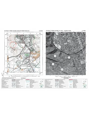
The questions below are based on the 1 : 50 000 topographic map 2530BD
MBOMBELA, as well as the orthophoto map of a part of the mapped area.
Various options are provided as possible answers to the following questions.
Choose the answer and write only the letter (A–D) in the block next to each
question.
1.1 The neighbouring country A on the general information map on page 3
is …
A Swaziland.
B Zimbabwe.
C Mpumalanga. D
D Mozambique.
1.2 The map index/reference of the topographic map to the south-east of
Mbombela is …
A 2530 DA.
B 2530 DB.
C 2530 DA. D
D 2531 CA.
1.3 According to the urban hierarchy Mbombela is classified as a …
A city.
B minor country town.
C hamlet. A
D metropolitan.
1.4 The N4 in blocks F3, F4 and F5 is found along a …
A plateau.
B watershed
C river valley. C
D interfluve.
1.5 The feature 1 on the orthophoto map is a …
A recreational ground.
B research.
C show ground. C
D sewerage works.
1.6 The true bearing of trigonometric station 111 (block G5) from spot height
1028 (block H5) is …
A 22°.
B 197°.
C 10°. A
D 108°.
Copyright reserved Please turn over
(EC/SEPTMBER 2018)
Downloaded from hlayiso.com
GEOGRAPHY P2 3
1.7 Feature B on the topographic map is a(n) …
A dam.
B cemetery.
C embankment. B
D excavation.
1.8 The slopes found between 2 and 3 on the orthophoto map indicate a …
slope.
A concaved
B terraced
C convexed C
D steep
1.9 Feature 4 on the orthophoto map is a …
A shopping centre.
B factory.
C hospital. D
D prison.
1.10 The man-made feature at 25°24'35"S 30°55'20"E on the topographic map
is a …
A windmill.
B power sub-station.
C factory. B
D trigonometric station.
1.11 The land-use zone numbered 5 on the orthophoto map is a …
A rural-urban fringe.
B high-income residential area.
C central business district. C
D industrial area.
1.12 The orthophoto map is an example of a ... photograph.
A high-angle oblique
B low-angle oblique
C horizontal D
D vertical aerial
Copyright reserved Please turn over
4
Downloaded from hlayiso.com
GEOGRAPHY P2 (EC/SEPTMBER 2018)
1.13 The man-made feature at 6 on the orthophoto map is a/are …
A lighthouse.
B telephone lines.
C communication tower. C
D power line.
1.14 When travelling in a southerly direction on the R40 from Mbombela, the
next central place settlement will be ...
A Barberton.
B Komatipoort.
C Mataffin. A
D Kaapmuiden.
1.15 The N4 passing Mbombela forms part of the … Spacial Development
Corridor.
A Lebombo
B Wild Coast
C Maputo C
D Phalaborwa
(15 x 1) (15)
[15]
Copyright reserved Please turn over
(EC/SEPTMBER 2018)
Downloaded from hlayiso.com
GEOGRAPHY P2 5
QUESTION 2: MAPWORK CALCULATIONS AND TECHNIQUES
2.1 Locate points 2 and 3 on the orthophoto map.
2.1.1 (a) Identify the indicator of height at 2.
Trigonometric beacon (1 x 1) (1)
(b) State the height at 2.
696 (m) (1 x 1) (1)
2.1.2 Calculate the average gradient between point 2 and point 3 on the
orthophoto map in metres.
Show ALL calculations. Marks will be awarded for calculations.
Vertical interval (VI)
Formula: Gradient =
Horizontal equivalent (HE)
VI = 696 m – 640 m = 56 m
HE = 11,4 cm x 100 m [range for measurement 11,3 cm to 11,5 cm]
= 1 140 m
Range [1 130 m – 1 150 m]
56
G = (Show division)
1 140
1
= 1 : 20,35 or
20,35
Range [1 : 20,17 – 1 : 20,53]
(5 x 1) (5)
2.1.3 Explain why your answer to QUESTION 2.1.2 indicates a gentle
gradient.
The slope rises very gently over a short distance.
For every 20,5 units that you move horizontally, you will rise 1 unit
vertically.
The relationship between the difference of the vertical interval and the
horizontal equivalent is large.
The ratio is more than 1 : 10 [Any ONE]
[MARK CONCEPT OF UNDERSTANDING STEEPNESS]
(1 x 1) (1)
Copyright reserved Please turn over
6
Downloaded from hlayiso.com
GEOGRAPHY P2 (EC/SEPTMBER 2018)
2.2 Using the information on the topographic map, determine the magnetic
declination for 2018. Show ALL calculations. Marks will be awarded for
calculations.
Difference in years: 2018 – 2014 = 4 years
Mean annual change: 5' W [(W) must be included]
Total change: 4 x 5' W = 20' W
Magnetic declination for 2018: 18°12' W + 20' W = 18°32' W
(5 x 1) (5)
2.3 Refer to the area demarcated in RED on the topographic map, which
represents the area covered by the orthophoto map.
2.3.1 Calculate the above area. Show ALL calculations. Marks will be
awarded for calculations.
Measurement range: length – 9,9 cm to 10,1 cm / 99 mm to 101 mm
breadth – 7,2 cm to 7,4 cm / 72 mm to 74 mm
[Accept any units]
Area = length x breadth
= (10,0 cm x 0,5) km x (7,3 cm x 0,5)
= 5,0 km x 3,65 km (4,95 km to 5,05 km x 3,6 km to 3,7 km)
= 18,25 km²
(Range is 17,82 km² to 18,69 km²)
NOTE: [Final answer in km²]
(5 x 1) (5)
2.4 Would the orthophoto map have a smaller or larger scale when compared to
the topographic map? Give a reason for your answer.
Answer: Larger
Explain: The scale of the topographic map is smaller
The scale of the orthophoto map is 1 : 10 000 and the scale of the
topographic map is 1 : 50 000
The scale of the orthophoto map is five times larger than that of the
topographic map
The scale of the topographic map is five times smaller than that of
the orthophoto map [Any ONE]
(2 x 1) (2)
[20]
Copyright reserved Please turn over
(EC/SEPTMBER 2018)
Downloaded from hlayiso.com
GEOGRAPHY P2 7
QUESTION 3: APPLICATION AND INTERPRETATION
3.1 Mbombela is situated alongside the Umgwenya River.
3.1.1 Name ONE physical feature that would hinder a canoeist (someone
using a small canoe) going downstream between C and D on the
topographic map.
Physical: Weir
Umgwenya Waterfall / Waterfall [Any ONE]
(1 x 1) (1)
3.1.2 Give a reason for your answer in QUESTION 3.1.1.
Explain: Weir – Knickpoint / alters flow characteristic of river /
changes height level of river causing a danger
Waterfall – Water flows over vertical drop causing a
danger [Any ONE]
(1 x 2) (2)
3.2 Refer to block H3, I3 and the sketch below.
3.2.1 Name the stream pattern evident in this basin.
Dendretic
(1 x 1) (1)
3.2.2 State TWO characteristics of the stream pattern identified in
QUESTION 3.2.1.
Branches like a tree
Distinct interfluves
The angle at which tributaries join is acute [Any TWO]
(2 x 1) (2)
Copyright reserved Please turn over
8
Downloaded from hlayiso.com
GEOGRAPHY P2 (EC/SEPTMBER 2018)
3.2.3 Complete the table below to show the number of tributaries for each
stream order.
Stream
order 1 2 3
Number of
tributaries 14 3 1
(2 x 1) (2)
3.2.4 Identify the type of river in this basin.
Non-perennial
(1 x 1) (1)
3.3 Refer to the Riverside Industrial Park labelled E (blocks F8, G8) on the
topographic map.
3.3.1 What is an industrial park?
Area planned for industrial development, which often has offices and
light industry, rather than heavy industry. [Concept]
(1 x 1) (1)
3.3.2 What are the economic benefits of the Riverside Industrial Park for
Mbombela and its location?
Close to the transport route N4/railway line Maputo Corridor
Mbombela gets funding from the national government for the SDI
Infrastructure in one place
Attracts new industry to one location
Job opportunities created
Boosts the economy of the city [Any TWO]
(2 x 2) (4)
3.4 Identify the following features labelled 7 and 8 on the orthophoto map.
7: Orchard / vineyard e.g. citrus
8: Railway station
(2 x 1) (2)
Copyright reserved Please turn over
(EC/SEPTMBER 2018)
Downloaded from hlayiso.com
GEOGRAPHY P2 9
3.5 The original N4 indicated in blocks G8, H9 and H10 has been deviated
(re-routed) to the north of Mbombela.
3.5.1 Explain why the N4 had to be deviated in order to go around the city.
To avoid traffic congestion in the city
Reduce noise and air pollution
CBD could not handle the large volume of traffic
Damage to roads due to increase of traffic volumes
N4 now quicker in linking Johannesburg to Maputo
Need to reach destination faster
Reduce accident rate/safer route
Buildt around an already established settlement [Any TWO]
(2 x 2) (4)
3.6 Refer to Mataffin residential area in block G6 on the topographic map.
3.6.1 Identify the street pattern of this land-use area.
Planned-irregular
(1 x 1) (1)
3.6.2 Discuss ONE advantage and ONE disadvantage of the street
pattern identified in QUESTION 3.6.1.
Advantages:
Free flow of traffic
Fewer traffic jams
Scenic drive
Follows the contour lines
Saves petrol
Saves time [Any ONE]
(1 x 2) (2)
Disadvantages:
Get lost easily
Lost people vulnerable to crime
Difficult to develop infrastructure
Difficult to lay-out
Many cul-de-sacs [Any ONE]
(1 x 2) (2)
[25]
Copyright reserved Please turn over
10
Downloaded from hlayiso.com
GEOGRAPHY P2 (EC/SEPTMBER 2018)
QUESTION 4: GEOGRAPHICAL INFORMATION SYSTEMS (GIS)
4.1 The following is a freehand sketch map of the area covered by the
topographic map in blocks A 8, 9, 10 / B 8, 9, 10 and C 8, 9, 10.
4.1.1 Identify the features H, I and J in the sketch as either a point, line or
polygon.
H: Woodland – polygon
I: Railway station – line
J: Powerline – line
(3 x 1) (3)
4.1.2 Give ONE advantage of using vector data.
Line, points and polygons are shown correctly.
Needs less storage space for data in the disk.
Lines and polygons fit together correctly. [Any ONE]
(1 x 2) (2)
4.1.3 Use the topographic map and identify the following features on the
sketch map.
Key: F: Curlew
G: Phumlani
(2 x 1) (2)
Copyright reserved Please turn over
(EC/SEPTMBER 2018)
Downloaded from hlayiso.com
GEOGRAPHY P2 11
4.1.4 State the spatial position of Curlew from Phumlani.
South / South East / South South East
(1 x 1) (1)
4.2 Refer to block F5 and F6 on the topographic map. the local district
municipality has decided to do an environmental impact study to evaluate
the influence a rubbish dump would have on the area.
4.2.1 Mention ONE way in which data can be collected to do an
environmental impact study.
Surveys / Questionnaires
Photographs
Remote sensing/satellite images
Testing of natural environment e.g. testing soil and water quality
Physical measurements using secondary data
Using existing maps [Any ONE]
(1 x 1) (1)
4.2.2 Identify TWO visible layers in block F6 that a GIS specialist would use
to evaluate the suitability of the dump site.
Relief / Slope / Gradient / Geology
Infrastructure: Roads / Railway line
Drainage / Rivers / Water [Any TWO]
(2 x 1) (2)
4.2.3 Give a reason for each of the answers to QUESTION 4.2.2.
Relief:
Slope needs to be flat for dumping
Soils must be suitable to prevent leaching
Suitable geological rock needed
Slope must be minimal which has infrastructural advantages and
reduces environmental impacts
Infrastructure:
Ensuring heavy vehicles would not damage roads
Quick access to city and surrounding areas
Dump close to transport routes – economic costs / close to
Mbombela
Drainage:
Minimal seepage into underground system − water pollution /
contamination
[Any TWO]
(2 x 2) (4)
[15]
TOTAL: 75
Copyright reserved Please turn over
Verified matching documents
The question paper, memo or addendum that belongs with this document.
Recommended for this subject
Published documents with matching subject and grade metadata.
Memorandum
Geography-Grade-12-NSC-MEMO-P1-May-June-2025-Free-State.pdf
Memorandum
Gr 12 Geography (English) June 2024 Possible Answers_hlayiso.com_.pdf
Memorandum
GEOGRAPHY GR12 MEMO JUNE 2023_English_hlayiso.com_.pdf
Memorandum
2023 MP June Memo_hlayiso.com_.pdf
Memorandum
2023 WC Prelim P1 Memo_hlayiso.com_.pdf
Memorandum
GEOGRAPHY P2 GR12 MEMO SEPT2022 English final_hlayiso.com_.pdf
Related documents
Matched using subject, grade, language, document type and exam metadata.
Memorandum
GEOGRAPHY P1 GR12 MEMO SEPT2018 English_hlayiso.com_.pdf
Memorandum
GEOGRAPHY P2 MEMO GR12 SEPT 2020 English_hlayiso.com_.pdf
Addendum
GEOGRAPHY P1 GR12 ADDENDUM SEPT2018 English_hlayiso.com_.pdf
Question paper
GEOGRAPHY P2 GR12 QP SEPT2018 Eng D_hlayiso.com_.pdf
Memorandum
Geography P1 Memo June 2018 English_hlayiso.com_.pdf
Memorandum
GEOGRAPHY P1 GR12 MEMO SEPT2017 English_hlayiso.com_.pdf
More from Grade 12 Geography
Explore more published documents in this catalogue.
Question paper
Geography-Grade-12-NSC-P2-QP-September-2025-KZN.pdf
Question paper
Geography P1 May-June 2025 Eng.pdf
Question paper
HARTBEESPOORT DAM1 D FINAL.pdf
Question paper
Geography P1 (English) QP_hlayiso.com_.pdf
Question paper
2023 KZN Prelim P2 QP_hlayiso.com_.pdf
Question paper