
PROVINCIAL ASSESMENT
GRADE 10
GEOGRAPHY P1
NOVEMBER 2024
MARKS: 150
TIME: 3 hours
This question paper consists of 17 pages.
Copyright reserved Please turn over
Skip to contentQuestion paper 
%20Controlled%20Test%201%202023%20Question%20Paper_hlayiso.com_--bf06e433-8b83-4cb3-a00a-28c97101f988/v1-e3ceb109619a47bc1bd5/card.webp)
/GEOGRAPHY%20P1%20GR10%20QP%20NOV2020_English.docx--aefbccc1-ec40-4766-8c8c-ddf8423198f8/v1-21898a99f80ef19b01dd/card.webp)
View all
Geography Grade 10 P1 North West November 2024 QP (Eng)
Grade 10 Geography Paper 1 question paper from the North West November Exam 2024 (English), 17 pages. Read online or get the free PDF download, memo linked when available.
Geography · Grade 10 · North West November Exam · 2024 · English. Question paper, 17 pages. Read online or download the PDF.
- Subject
- Geography
- Grade
- Grade 10
- Language
- English
- Document type
- Question paper
- Year
- 2024
- Exam period
- North West November Exam
- Paper
- 1
- Curriculum
- CAPS
- Pages
- 17
- File size
- 1.1 MB
Loading document…
Loading document…
1 of 17
Document textSearch extracted text and jump to a page.
Geography/P1 2 NW/November 2024
Grade 10
INSTRUCTIONS AND INFORMATION
1. This question paper consists of TWO sections:
SECTION A
QUESTION 1: THE ATMOSPHERE (60)
QUESTION 2: GEOMORPHOLOGY (60 )
SECTION B
QUESTION 3: GEOGRAPHICAL SKILLS AND TECHNIQUES (30)
2. Answer ALL THREE questions.
3. ALL diagrams are included in the QUESTION PAPER.
4. Leave a line between subsections of questions answered.
5. Start EACH question at the top of a NEW page.
6. Number the answers correctly according to the numbering system used in this
question paper.
7. Do NOT write in the margins of the ANSWER BOOK.
8. Draw fully labelled diagrams when instructed to do so.
9. Answer in FULL SENTENCES, except when you have to state, name, identify
or list.
10. Units of measurement MUST be indicated in your final answer, e.g. 1 020 hPa,
14 °C and 45 m.
11. You may use a non-programmable calculator.
12. You may use a magnifying glass.
13. Write neatly and legibly.
SPECIFIC INSTRUCTIONS AND INFORMATION FOR SECTION B
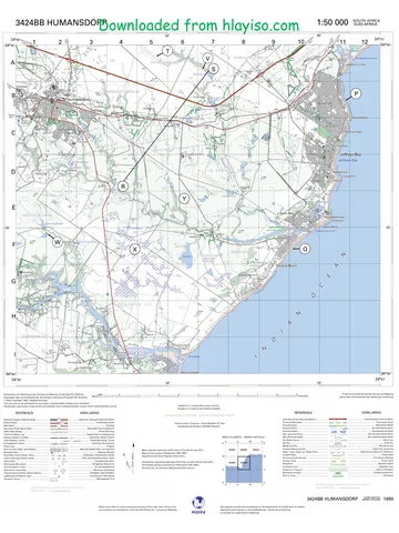
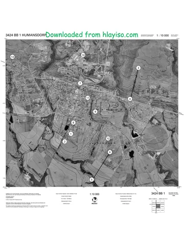
14. 1 : 50 000 topographical map 2931 CA VERULAM and a 1 : 10 000 orthophoto
map 2931CA VERULAM are provided.
15. The area demarcated in RED/BLACK on the topographical map represents the
area covered by the orthophoto map.
16. Show ALL calculations. Marks will be allocated for steps in calculations
17. You must hand in the topographical and orthophoto map to the invigilator at the
end of this examination.
Copyright reserved Please turn over
Geography/P1 3 NW/November 2024
Grade 10
SECTION A: THE ATMOSPHERE AND GEOMORPHOLOGY
QUESTION 1 THE ATMOSPHERE
1.1 Refer to the sketch below, showing the water cycle. Choose from EVAPORATION,
CONDENSATION or PRECIPITATION to match the descriptions below. Write only
the correct answer next to the question numbers (1.1.1 to 1.1.7) in the
ANSWERBOOK e.g.1.1.8 precipitation.
[Source: Google
IMAGE]
1.1.1 … occurs when water changes from a liquid to a gas.
1.1.2 … happens when water changes from a gas to liquid.
1.1.3 … occurs when water falls from clouds.
1.1.4 Snow is an example of …
1.1.5 The heating of water surfaces will result into …
1.1.6 Mist is an example of …
1.1.7 Clouds form when … occurs. (7 x 1) (7)
Copyright reserved Please turn over
Geography/P1 4 NW/November 2024
Grade 10
1.2 Choose the correct word(s) from those given in brackets. Write only the word(s)
next to the question numbers (1.2.1 to 1.2.8) in the ANBWERBOOK e.g.,
1.2.9 Moon.
1.2.1 (Insolation/Reflection) is the amount of incoming sunlight that is bounced
off clouds and Earth’s surface back into space.
1.2.2 (Insolation/Absorption) is the amount of incoming sunlight that strikes a
surface.
1.2.3 Transfer of heat in the form of waves is known as (reflection/radiation).
1.2.4 (Conduction/convection) is the transfer of heat between substances that
are in indirect contact with each other.
1.2.5 The transfer of heat by air circulation of warm and cold air is called
(conduction/convection).
1.2.6 (Latitude/Albedo) is a measure of how much a surface reflects heat.
1.2.7 (Ocean currents/River flow) are large-scale circulations of ocean water.
1.2.8 The Sun’s energy is called (solar radiation/terrestrial radiation). (8 x 1) (8)
Copyright reserved Please turn over
Geography/P1 5 NW/November 2024
Grade 10
1.3 Refer to the graph below, showing how temperature changes with height between
the different layers of the atmosphere.
[Source: https//usactionnews.com]
1.3.1 Define the concept of atmosphere. (1 x 2) (2)
1.3.2 Choose the correct word from those given in brackets that describes the
temperature pattern:
In the troposphere, it gets (colder/hotter) with an increase in height, in
other words, the temperature (increases/decreases)
with altitude. (2 x 1) (2)
1.3.3 Describe the temperature pattern in the thermosphere. (1 x 1) (1)
1.3.4 Explain why temperature increases in the stratosphere. (1 x 2) (2)
1.3.5 In which layer of the atmosphere will you find the ozone layer? (1 x 1) (1)
1.3.6 Name ONE human activity responsible for ozone depletion. (1 x 1) (1)
1.3.7 Explain the importance of the ozone layer for human life. (1 x 2) (2)
1.3.8 Suggest methods that can be implemented to reduce ozone depletion.
(2 x 2) (4)
Copyright reserved Please turn over
Geography/P1 6 NW/November 2024
Grade 10
1.4 Refer to the extract on Global warming.
DUE TO CLIMATE CHANGE THE COUNTRY’S RAINFALL PATTERNS HAVE
BECOME MORE ERRATIC, LEADING TO FLASH FLOODS AND WATER
SCARCITY IN SOME AREAS
The drastic swing between extreme drought and unprecedented flooding is
becoming common in South Africa.
Water stress is expected to significantly affect poor, disenfranchised communities
as well as ecosystems that have been underfunded and exploited.
The intensity of extreme drought and rainfall has “sharply” increased over the past
years. These are not merely tough weather events, they are leading to extremes
such as crop failure, infrastructure damage, and even humanitarian crises.
[Adapted from www.greenpeace.org]
1.4.1 Define the concept of global warming. (1 x 2) (2)
1.4.2 Name ONE human factor that contributes to global warming. (1 x 1) (1)
1.4.3 According to the article, which weather conditions have become more
common in South Africa because of global warming? (2 x 1) (2)
1.4.4 Describe TWO consequences of global warming mentioned in the extract.
(2 x 1) (2)
1.4.5 In a paragraph of approximately EIGHT lines, recommend sustainable
solutions the government can implement to stop or slow down global
warming and climate change. (4 x 2) (8)
Copyright reserved Please turn over
Geography/P1 7 NW/November 2024
Grade 10
1.5 Refer to the sketches below on types of rainfall and synoptic weather map
[Source: Google image]
1.5.1 What are the black lines on the synoptic map called? (1 x 1) (1)
1.5.2 Is the pressure cell at A, a high or low-pressure cell? (1 x 1) (1)
1.5.3 State ONE factor evident on the synoptic weather map to substantiate your
answer to QUESTION 1.5.2 (1 x 2) (2)
1.5.4 Describe the windspeed of station model D. (1 x 1) (1)
1.5.5 Identify the front at F. (1 x 1) (1)
1.5.6 What type of rainfall is associated with the system at F? (1 x 1) (1)
1.5.7 Explain the formation of the type of rainfall, mentioned in QUESTION 1.5.6
(2 x 2) (4)
1.5.8 Differentiate between convectional and orographic rainfall. (2 x 2) (4)
[60]
Copyright reserved Please turn over
Geography/P1 8 NW/November 2024
Grade 10
QUESTION 2: GEOMORPHOLOGY
2.1 Refer to the sketches below, which show different types of folding. Complete the
statement in COLUMN A with the options in COLUMN B. Write only Y or Z to the
question numbers (2.1.1 to 2.1.8) in the ANSWER BOOK, e.g. 2.1.9 Z.
[Source: https//www.bling.com//images]
COLUMN A COLUMN B
2.1.1 An uphold Y Syncline
Z Anticline
2.1.2 A downfold Y Syncline
Z Anticline
2.1.3 A pointed or peaked fold Y Chevron fold
Z Overturned fold
2.1.4 A fold with equal sides Y Symmetrical fold
Z Asymmetrical fold
2.1.5 The sloping beds on either side of an axial Z Limbs:
plane Y Crests
2.1.6 A tilted or bend-over fold Z Symmetrical fold:
Y Asymmetrical fold
2.1.7 An overturned fold that flopped over Z Isoclinal fold
Y Recumbent fold
2.1.8 A very tight fold, in which the limbs are Z Isoclinal fold
parallel or parallel to one another Y Recumbent fold
(8 x 1) (8)
Copyright reserved Please turn over
Geography/P1 9 NW/November 2024
Grade 10
2.2 Various options are provided to answer the following questions, Choose the
answer and write only the letter (A D) next to the question numbers (2.2.1 to 2.2.7)
in the ANSWERBOOK, e.g. 2.2.8. D.
[Source:
https//www.bling.com//images]
2.2.1 The very thin solid, brittle top layer of the Earth, indicated as number 1, is
known as the …
A inner core.
B outer core.
C mantle.
D crust.
2.2.2 The inner core is labelled by the letter ...
A 1
B 2
C 3
D 4
2.2.3 The outer core is labelled by the letter ...
A 1
B 2
C 3
D 4
Copyright reserved Please turn over
Geography/P1 10 NW/November 2024
Grade 10
2.2.4 The inner core of the Earth is made up of …
A liquid iron and nickel.
B solid iron and nickel.
C liquid silicon and aluminium.
D solid silicon and aluminium.
2.2.5 The layer of the earth that is mined for minerals and oil.
A Inner core
B Outer core
C Mantle
D Crust
2.2.6 The layer responsible for the Earth’s magnetic field, labelled as 4, is the …
A inner core.
B outer core.
C mantle.
D crust.
2.2.7 The mantle, layer 2 consists of …
A magma.
B lava.
C water.
D solid rock. (7 x 1) (7)
Copyright reserved Please turn over
Geography/P1 11 NW/November 2024
Grade 10
2.3 Study the sketch below of landforms associated with plate boundaries.
[Source:
https://2.bp.blogspot.com]
2.3.1 Define the concept plate tectonics? (1 x 2) (2)
2.3.2 Choose the correct word(s) from those given in brackets.
(a) Plates push together at a (divergent/ convergent/transform fault)
boundary.
(b) At a (divergent/ convergent/ transform fault) boundary, plates
slide past each other.
(c) Plates move apart at a (divergent/convergent/transform fault)
boundary. (3 x 1) (3)
2.3.3 Name ONE landform formed when convergence occurs between two
oceanic plates. (1 x 1) (1)
2.3.4 Name ONE landform formed when convergence occurs between two
plates. (1 x 1) (1)
2.3.5 Distinguish between mid-oceanic ridges and oceanic trenches by referring
to the different ways they form. (2 x 2) (4)
2.3.6 Explain what causes tectonic plates to move. (2 x 2) (4)
Copyright reserved Please turn over
Geography/P1 12 NW/November 2024
Grade 10
2.4 Refer to the extract and a map of South Africa below based on an earthquake.
Earthquake of 5.3 magnitude! (Amended to 5,5 by experts at a depth of
10 km)
Centred in Orkney, 120 km Southwest of Johannesburg! An area with many gold
mines. At around 13h15 South African gold miners with head offices in
Johannesburg and Sandton advised that they had felt the earthquake at their
head offices but have so far received no reports of damage from their mines.
Earthquakes and deep-level mining do not bode well, and I hope that no mine
workers will be injured.
Measuring 5.3; today’s earthquake can be described as ‘Moderate’. It can cause
damage to buildings with poor construction, and everybody will feel its tremors. On
a global scale, approximately 500-1500 of these earthquakes occur per year. Only
earthquakes that reach above 7 cause great damage to buildings and are classified
as Major (around 7) and Great (above 8). Earthquakes of magnitude 8 release an
equal amount of energy to 6 million tons of TNT.
[Source: Roots 'n' Shoots: Earthquake hits Central South Africa! (rsands.blogspot.com)]
2.4.1 What instrument is used to measure the magnitude of an earthquake?
(1 x 1) (1)
2.4.2 What is the epicentre of an earthquake? (1 x 2) (2)
2.4.3 Where was the epicentre of this earthquake? (1 x 1) (1)
2.4.4 Quote from the extract, which described the earthquake as only moderate.
(1 x 1) (1)
Copyright reserved Please turn over
Geography/P1 13 NW/November 2024
Grade 10
2.4.5 Explain why mining activity can be the possible cause of this earthquake.
(1 x 2) (2)
2.4.6 In a paragraph of approximately EIGHT lines, explain the effects of
earthquakes and suggest ways on how the impact of earthquakes can be
reduced. (4 x 2) (8)
2.5 Study the sketch below showing a cross-section through a volcano.
[Source: Google image]
2.5.1 Define the term volcano. (1 x 2) (2)
2.5.2 Identify the type of volcano illustrated in the sketch. (1 x 1) (1)
2.5.3 Justify your answer in QUESTION 2.5.2. (1 x 2) (2)
2.5.4 Differentiate between the vent and crater of a volcano. (2 x 2) (4)
2.5.5 Explain the positive economic impact of volcanoes on a country.
(3 x 2) (6)
[60]
TOTAL SECTION A: 120
Copyright reserved Please turn over
Geography/P1 14 NW/November 2024
Grade 10
SECTION B
QUESTION 3: GEOGRAPHICAL SKILLS AND TECHNIQUES
GENERAL INFORMATION ON VERULAM
Coordinates: 29°35’S; 31°0’E
The town of Verulam is 170 years old and located to the north of Durban. It has a
population of over 60 000 people. Verulam consists of densely populated residential
and industrial areas like Canelands. On the outskirts are large farming areas where the
main crop grown is sugar cane. There has been slow but steady progress in
modernising the town by providing improved infrastructure to the rural areas.
The Hazelmere Dam, just a few kilometres north of Verulam, is the main source of water
for the area and is used for a variety of activities, such as watersports and fishing. One
of the main rivers that flows through Verulam is the Mdloti River in which the Hazelmere
Dam has been built. An interesting fact is that Verulam is the only town in the world
where the main street (Wick Street) ends in a river.
[Source: Adapted from https://www.google.com/search?q=map+of+Verulam]
The following English terms and their Afrikaans translations are shown on the
topographic map:
ENGLISH AFRIKAANS
Diggings Uitgrawings
River Rivier
Copyright reserved Please turn over
Geography/P1 15 NW/November 2024
Grade 10
3.1 MAP SKILLS AND CALCULATIONS
3.1.1 The map code 2931CA VERULAM indicates that the town lies
on the …
A 29° E longitude and 31° N latitude
B 29° S longitude and 31° E latitude
C 29° E latitude and 31° N longitude
D 29° S latitude and 31° E longitude (1 x 1) (1)
3.1.2 The map scale of the topographical map is … than the map
scale orthophoto image.
A 5 times larger
B 5 times smaller
C 20 times larger
D 20 times smaller (1 x 1) (1)
3.1.3 The contour interval on the orthophoto is …
A 5 tm.
B 20 m.
C 25 m.
D 10 m. (1 x 1) (1)
3.1.4 What is the meaning of the topographical map scale 1 : 50 000. (1 x 1) (1)
3.1.5 Calculate the distance (length) between the spot height 132 (H) in block
B2 and spot height 161 (I) in block A2 in meters.
FORMULA: Map distance x Scale (2 x 1) (2)
Refer to spot height 161 (I) in block A2 and spot height 132 (H) in block
B2 on the topographical map.
3.1.6 Determine the true bearing of spot height 132 (H) in block B2 from spot
height 161 (I) in block A2. (1 x 2) (2)
3.1.7 Calculate the present magnetic bearing of QUESTION 3.1.6. The
magnetic declination for 2024 is 26º 16’ West of True North.
FORMULA: MB = True Bearing + Magnetic Declination (2 x 1) (2)
Copyright reserved Please turn over
Geography/P1 16 NW/November 2024
Grade 10
3.2 MAP INTERPRETATION
3.2.1 Give ONE similarity between an orthophoto and a topographical map.
(1 x 1) (1)
3.2.2 Name the international airport found on the topographical map. (1 x 1) (1)
Refer to the orthophoto map.
3.2.3 Which time of the day (morning/afternoon) was the photograph taken?
(1 x 1) (1)
3.2.4 Explain your answer to QUESTION 3.2.3. (1 x 2) (2)
3.2.5 Name ONE advantage of using an orthophoto map rather than a
topographical map. (1 x 1) (1)
3.2.6 Explain the purpose of the row of trees block C1 on the topographical map.
(1 x 2) (2)
3.2.7 Refer to the topographical map. Is the slope of the land between F (in block
C5) and G (in block B5) gentle or steep? (1 x 1) (1)
3.2.8 Motivate your answer in QUESTION 3.2.7. (1 x 2) (2)
3.2.9 What type of road is the N17? (1 x 1) (1)
3.3 GEOGRAPHICAL INFORMATION SYSTEMS
Refer to the sketch below of GIS.
[Source: https//wwwbling.com//images]
3.3.1 Define the concept Geographical Information System. (1 x 2) (2)
3.3.2 Explain why people are important in the GIS process. (1 x 2) (2)
Copyright reserved Please turn over
Geography/P1 17 NW/November 2024
Grade 10
3.3.3 Name ONE hardware device that can capture information into the
system. (1 x 1) (1)
3.3.4 What is collecting spatial data about an object or event and taking an
image of it from a distance called? (1 x 1) (1)
3.3.5 Explain the importance of using GIS in today’s fast-changing world.
(1 x 2) (2)
TOTAL SECTION B: 30
GRAND TOTAL: 150
Copyright reserved
Study this subject
Revise the topics in this paper, then practise them question by question.
- Grade 10 Geography notes
CAPS revision notes with worked examples.
- Geography questions by topic
Past exam questions sorted by CAPS topic, with memos where available.
- Grade 10 Geography quizzes
Short topic quizzes with instant feedback.
- All Grade 10 Geography past papers
Past papers by year, with memos where available.
- Grade 10 past papers
More Geography and other subjects in this collection.
Recommended for this subject
More papers and memos for this grade and subject.
Question paper
Geography Grade 10 North West June 2024 Question Paper (English)
Question paper
Geography Grade 10 P2 North West November 2024 QP (Eng)
Question paper
Geography Grade 10 Gauteng March Test 2023 Question Paper (Eng)
Question paper
Geography Grade 10 Eastern Cape November 2020 Question Paper
Question paper
Geography Grade 10 Eastern Cape November 2020 Question Paper
Question paper
Geography Grade 10 P1 Eastern Cape November 2020 QP (Eng)
Related documents
Question paper
Geography Grade 10 P1 2020 QP (Eng)
Question paper
Geography Grade 10 P1 Eastern Cape November 2018 QP (Eng)
Question paper
Geography Grade 10 P1 Eastern Cape November 2017 QP (Eng)
Question paper
Geography Grade 10 P1 National November 2017 Question Paper (Eng)
Addendum
Geography Grade 10 P1 Eastern Cape November 2020 Addendum (Eng)
Memorandum
Geography Grade 10 P1 Eastern Cape November 2020 Memo (English)
More from Grade 10 Geography
Study guide
Gr10 Geografie OG studyguide LR
Annual teaching plan
Gr 10 Geo ATP 2023 24
Question paper and memo
Geography Grade 10 Free State March Test 2025 Paper & Memo
Question paper and memo
Geography Grade 10 Paper 1 Limpopo June 2025 Paper & Memo
Question paper and memo
Geography Grade 10 Eastern Cape June 2024 Paper & Memo
Addendum