
NATIONAL
SENIOR CERTIFICATE
GRADE 10
NOVEMBER 2020
GEOGRAPHY P1
(EXEMPLAR)
MARKS: 150
TIME: 3 hours
This question paper consists of 10 pages.
Skip to contentAll 2020 papers 
View all

Geography Grade 10 P1 2020 QP (Eng)
Grade 10 Geography Paper 1 question paper from the Mpumalanga National Exemplar Exam (NSC) 2020 (English), 10 pages. Read online or download the free PDF.
Geography · Grade 10 · Mpumalanga National Exemplar Exam (NSC) · 2020 · English. Question paper, 10 pages. Read online or download the PDF.
- Subject
- Geography
- Grade
- Grade 10
- Language
- English
- Document type
- Question paper
- Year
- 2020
- Exam period
- Mpumalanga National Exemplar Exam (NSC)
- Paper
- 1
- Curriculum
- CAPS
- Pages
- 10
- File size
- 605.9 KB
Free to read online, no sign-up needed
Loading document…
Loading document…
1 of 10
This exam
Mpumalanga National Exemplar Exam (NSC) 2020
- Paper 1Question paperMemo
- Other filesQuestion paper
Questions in this paper
Document textSearch extracted text and jump to a page.
2 GEOGRAPHY P1 (EC/NOVEMBER 2020)
INSTRUCTIONS AND INFORMATION
1. This question paper consists of THREE questions.
2. Answer ALL the questions in this question paper.
3 Answer QUESTION 3 (MAPWORK) on the spaces provided in this question
paper.
Detach QUESTION 3 from the question paper and attach it to your ANSWER
BOOK.
4 Use the following material:
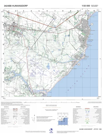
An extract from the topographical map 3424BB HUMANSDORP.
Orthophoto map 3424 BB 1 HUMANSDORP.
5. All diagrams are included in the ADDENDUM.
6. Leave a line between subsections of questions answered.
7. Start EACH question on a NEW page.
8. Number the answers correctly according to the numbering system used in this
question paper.
9. Number the answers in the centre of the line.
10. Do NOT write in the margins of the ANSWER BOOK.
11. Draw fully labelled diagrams when instructed to do so.
12. Answer in FULL SENTENCES, except where you have to state, name, identify
or list.
13. Write neatly and legibly.
Copyright reserved Please turn over
(EC/NOVEMBER 2020) GEOGRAPHY P1 3
SECTION A: THE ATMOSPHERE
QUESTION 1
1.1 Various options are provided as possible answers to the following questions.
Choose the correct answer and write only the letter (A–D) next to the
question numbers (1.1.1–1.1.8) in the ANSWER BOOK, for example 1.1.9 D.
1.1.1 A process whereby areas become more arid and drier like a desert,
is …
A drought.
B desertification.
C climate change.
D ozone depletion.
1.1.2 The transfer of heat by vertical movement is …
A convection.
B conduction.
C coriolis force.
D latent heat.
1.1.3 Gases in the atmosphere that absorb long-wave radiation and
contribute to global warming are known as the …
A radiation gases.
B thermosphere.
C greenhouse effect.
D greenhouse gases.
1.1.4 The layer of atmosphere closest to the earth’s surface is the …
A mesosphere.
B tropopause.
C stratosphere.
D troposphere.
1.1.5 Chemicals used in some aerosol sprays, refrigerants, air conditioners
and industrial cleaning materials are known as …
A oxygen atoms.
B chlorine carbons.
C pollutants.
D chlorofluorocarbons.
1.1.6 Moisture which falls from the atmosphere onto the earth’s surface
is …
A thunderstorm.
B fog.
C precipitation.
D rainfall.
Copyright reserved Please turn over
4 GEOGRAPHY P1 (EC/NOVEMBER 2020)
1.1.7 Ice which collects on plants and the ground surface is …
A frost.
B dew.
C cirrus.
D stratus.
1.1.8 A map showing a summary of the weather conditions of a place is ...
A meteorology.
B weather forecast.
C a synoptic weather map.
D climatology. (8 x 1) (8)
1.2 Match the terms in COLUMN B with the descriptions in COLUMN A. Write
only the correct letter (A–I) next to the corresponding question numbers
(1.2.1–1.2.7) in your ANSWER BOOK, for example 1.2.8 K.
COLUMN A COLUMN B
1.2.1 Large, dense, towering clouds that A insolation
cause thunderstorms
1.2.2 The permanent gas that makes up 21% B terrestrial radiation
of the atmosphere and is necessary for
respiration
1.2.3 A molecule of three oxygen atoms C tropopause
which absorb ultraviolet rays
1.2.4 Incoming solar radiation D cumulonimbus clouds
1.2.5 The heat energy that the earth radiates E scattering
1.2.6 The upper layer of the troposphere F ozone
1.2.7 Radiation bounces off particles of dust G reflection
in the atmosphere
H oxygen
(7 x 1) (7)
1.3 Refer to FIGURE 1.3 showing the effects of global warming.
1.3.1 Define the term global warming. (1 x 1) (1)
1.3.2 Identify TWO effects of global warming in FIGURE 1.3. (2 x 1) (2)
1.3.3 List any TWO gases that contribute to global warming (2 x 1) (2)
1.3.4 Explain TWO factors that caused the effects identified in
QUESTION 1.3.2. (2 x 2) (4)
1.3.5 Discuss THREE sustainable strategies (ways) to reduce global
warming. (3 x 2) (6)
Copyright reserved Please turn over
(EC/NOVEMBER 2020) GEOGRAPHY P1 5
1.4 Refer to FIGURE 1.4 showing convectional rainfall and answer the following
questions.
1.4.1 Convectional rainfall is common in (summer/winter). (1 x 1) (1)
1.4.2 This type of rainfall is common in the (Western Cape/ Gauteng)
province of South Africa. (1 x 1) (1)
1.4.3 (a) Name the type of cloud labelled A. (1 x 1) (1)
(b) Describe TWO weather conditions associated with the type
of cloud mentioned in QUESTION 1.4.3 (a). (2 x 1) (2)
1.4.4 Mention TWO benefits of convectional rainfall to livestock farmers.
(2 x 1) (2)
1.4.5 In a paragraph of approximately EIGHT lines, discuss the negative
impacts of thunderstorms on people and the environment. (4 x 2) (8)
1.5 Refer to FIGURE 1.5 showing a synoptic weather map and answer the
questions that follow.
1.5.1 Lines drawn on synoptic weather maps showing places of equal
pressure are (isobars/isohyets). (1 x 1) (1)
1.5.2 Identify the following types of pressure at:
(a) A (1 x 1) (1)
(b) B (1 x 1) (1)
1.5.3 What is the pressure reading in Cape Town? (1 x 2) (2)
1.5.4 (a) Is this weather map representative of summer or winter? (1 x 1) (1)
(b) Give a reason for your answer in QUESTION 1.5.4 (a). (1 x 2) (2)
1.5.5 Describe the weather of Port Elizabeth by copying and completing the
table below:
Air temperature
Wind direction
Wind speed
Precipitation
Cloud cover
(5 x 1) (5)
1.5.6 Draw the symbol of thunderstorm represented on a synoptic weather
map. (1 x 2) (2)
[60]
Copyright reserved Please turn over
6 GEOGRAPHY P1 (EC/NOVEMBER 2020)
QUESTION 2: GEOMORPHOLOGY
2.1 Various options are provided as possible answers to the following questions.
Choose the correct answer and write only the letter (A–D) next to the question
numbers (2.1.1–2.1.8) in the ANSWER BOOK, for example 2.1.9 D.
2.1.1 The study of the earth’s physical features and the processes that
formed them is …
A meteorology.
B climatology.
C geomorphology.
D demography.
2.1.2 A mushroom–shaped structure which forms when magma forces the
overlying areas upwards is a …
A laccolith.
B batholith.
C mesa.
D butte.
2.1.3 The theory that the continents were once one landmass but they
drifted apart over time, is called ...
A maritime drift.
B continental geomorphology.
C maritime continental.
D continental drift.
2.1.4 The single landmass that existed over millions of years ago is …
A Australia.
B Pangaea.
C Laurasia
D Africa.
2.1.5 The outer layer of the earth that consists of solid rocks is/are the …
A crust.
B magma.
C crystals.
D inner core.
2.1.6 … is the largest of all igneous intrusions.
A Dyke
B Sill
C Batholith
D Laccolith
Copyright reserved Please turn over
(EC/NOVEMBER 2020) GEOGRAPHY P1 7
2.1.7 Which of the following are landforms associated with extrusive igneous
rocks?
A Mesa, butte and conical hill
B Batholith and laccolith
C Dyke and mesa
D Sill and conical hill
2.1.8 The cycle of rock formation, erosion of rocks, deposition of sediments
and formation of new rocks is known as the …
A metamorphic cycle.
B hydrological cycle.
C geological cycle.
D rock cycle. (8 x 1) (8)
2.2 Refer to FIGURE 2.2 which shows the structure of an earthquake.
2.2.1 The vibration of the earth’s crust is called (earthquake/folding). (1 x 1) (1)
2.2.2 Label the igneous intrusions indicated by letters A, B, C and D as
focus, epicentre, seismic waves and fault line. (4 x 1) (4)
2.2.3 An earthquake of over 8,0 magnitude on the Richter Scale indicates
(less destruction/more destruction). (1 x 1) (1)
2.2.4 A (seismograph/barometer) is an instrument that measures the
magnitude of seismic waves. (1 x 1) (1)
2.3 Refer to FIGURE 2.3 showing types of folds and faults.
2.3.1 Differentiate between folding and faulting. (2 x 1) (2)
2.3.2 Write down the correct term for each of the following types of folds.
(a) An upfold (1 x 1) (1)
(b) A downfold (1 x 1) (1)
2.3.3 Name the types of faults in the following labels.
(a) X (1 x 1) (1)
(b) Y (1 x 1) (1)
2.3.4 The type of force that resulted in landform X is (compressional/
tensional) force. (1 x 1) (1)
2.3.5 Faulting resulted in the formation of lakes such as Lake Victoria and
the formation of Mount Kilimanjaro. In a paragraph of approximately
EIGHT lines, discuss the importance of Lake Victoria and Mount
Kilimanjaro to the people of East Africa. (4 x 2) (8)
Copyright reserved Please turn over
8 GEOGRAPHY P1 (EC/NOVEMBER 2020)
2.4 Refer to FIGURE 2.4 detailing different collections of igneous rocks and answer
the questions that follow.
2.4.1 Define the term igneous rock. (1 x 1) (1)
2.4.2 Name any THREE types of igneous rocks from FIGURE 2.4.
(3 x 1) (3)
2.4.3 Igneous rocks form from magma. What is magma? (1 x 1) (1)
2.4.4 Explain how igneous rocks are formed. (2 x 2) (4)
2.4.5 Discuss THREE uses of igneous rocks. (3 x 2) (6)
2.5 Study the extract in FIGURE 2.5 about tsunamis and answer the questions
that follow.
2.5.1 State the percentages of the population that lost their lives in:
(a) 2004 (1 x 1) (1)
(b) 2011 (1 x 1) (1)
2.5.2 List ONE early warning system Japan set up to minimise the impact
of tsunamis. (1 x 1) (1)
2.5.3 Discuss the impact of tsunamis on the people living along the coast
of Indian Ocean. (3 x 2) (6)
2.5.4 How would you advise coastal communities to prepare in advance
so that they cope during and after a tsunami? (3 x 2) (6)
[60]
TOTAL SECTION A: 60
Copyright reserved Please turn over
(EC/NOVEMBER 2020) GEOGRAPHY P1 9
SECTION B: MAPWORK
The following questions are based on the 1 : 50 000 topographical map 3424 BB
HUMANSDORP as well as the orthophoto map 3424 BB 1 HUMANSDORP of a part
of the mapped area.
QUESTION 3
3.1 MAPWORK CALCULATIONS AND TECHNIQUES
3.1.1 Choose the correct word/phrase between brackets.
(a) The contour interval of the orthophoto map is (20 metres/5 metres).
(1 x 1) (1)
(b) The 1: 50 000 scale of the topographic map is 5 times
(larger/smaller) than the 1: 10 000 scale of the orthophoto map.
(1 x 1) (1)
(c) The feature found at grid location 34°04′55″S/24°45′ 57″E is a
(dam/trigonometrical beacon). (1 x 1) (1)
3.1.2 Refer to the feature numbered 1 on the orthophoto map.
Calculate in km2, the area of the feature numbered 1 on the orthophoto
map. Show ALL calculations. Marks will be awarded according to your
calculations. (4 x 1) (4)
3.1.3 Refer to block A5 on the topographic map.
(a) Calculate the difference in height between spot height 209 and
trigonometrical beacon number 139. (2 x 1) (2)
(b) Is the slope steep or gentle between the two points named in
QUESTION 3.1.3 (a)? (1 x 1) (1)
3.2 MAP AND PHOTO APPLICATION AND INTERPRETATION
3.2.1 Refer to both the topographical and orthophoto map.
(a) Identify the human-made feature found between points marked 3
and 4. (1 x 1) (1)
(b) Name the river that joins the ocean in block I6. (1 x 1) (1)
(c) What is the source of the water found in block B2? (1 x 1) (1)
3.2.2 Study the temperature graph of Jeffreys Bay, FIGURE 3.2.2 together with
block C/D11 on the topographic map.
(a) State the month with the minimum temperature. (1 x 1) (1)
(b) In which month was the lowest monthly temperature range
recorded? (1 x 2) (2)
Copyright reserved Please turn over
10 GEOGRAPHY P1 (EC/NOVEMBER 2020)
3.2.3 Describe how excavation in block B6 can be harmful to the environment
and human activity (2 x 2) (4)
3.2.3 Suggest ONE reason why the people of KwaNomzamo settlement would
consider the dams in block C3 as a threat to their lives during flooding.
(1 x 2) (2)
3.3 GIS
3.3.1 Write the acronym GIS in full. (1 x 1) (1)
3.3.2 Is the orthophoto map an example of a vertical or an oblique
photograph? (1 x 1) (1)
3.3.3 Refer to block C3 on the topographic map. Classify the following features
under node (point), linear (line) and polygon (area).
Draw the table below in your ANSWER BOOK and mark with an X in the
space that corresponds with the feature in block C3.
FEATURE NODE LINEAR POLYGON
Cultivated
land
Reservoir
Main road
(3 x 1) (3)
3.3.4 Study the diagram in FIGURE 3.3.3 that shows data layers together with
block D2.
(a) In GIS data layers are called ... (1 x 1) (1)
(b) Explain the importance of using GIS in today’s fast-changing world.
(1 x 2) (2)
[30]
TOTAL SECTION B: 30
GRAND TOTAL: 150
Copyright reserved Please turn over
Study this subject
Recommended for this subject
Addendum
Geography Grade 10 P1 Eastern Cape November 2020 Addendum
Question paper
Geography Grade 10 2020 QP
Question paper
Geography Grade 10 P1 Eastern Cape November 2018 QP (Eng)
Question paper
Geography Grade 10 P1 Eastern Cape November 2017 QP (Eng)
Question paper
Geography Grade 10 P1 National November 2017 QP (Eng)
Addendum
Geography Grade 10 P2 Eastern Cape November 2020 Addendum
More from Grade 10 Geography
Study guide
Gr10 Geografie OG studyguide LR
Annual teaching plan
Gr 10 Geo ATP 2023 24
Question paper and memo
Geography Grade 10 Free State March Test 2025 Paper & Memo
Question paper and memo
Geography Grade 10 Paper 1 Limpopo June 2025 Paper & Memo
Question paper and memo
Geography Grade 10 Eastern Cape June 2024 Paper & Memo
Memorandum