
GRADE 10 ____
NAME:
SURNAME:
NATIONAL
SENIOR CERTIFICATE
GRADE 10
NOVEMBER 2017
GEOGRAPHY P2
MARKS: 75
TIME: 1½ hours
MARKS HOD CLUSTER PROVINCIAL
TOTAL
MOD.
Q1 15 MARKS
Q2 20
Q3 25 75 75
Q4 15
This question paper consists of 13 pages, including 1 page for rough work and calculations.
*XGEOE2*
Skip to contentQuestion paper 
%20Controlled%20Test%201%202023%20Question%20Paper_hlayiso.com_--bf06e433-8b83-4cb3-a00a-28c97101f988/v1-e3ceb109619a47bc1bd5/card.webp)
View all
Geography Grade 10 P2 National November 2017 Question Paper (Eng)
Grade 10 Geography Paper 2 question paper from the National November Exam 2017 (English), 16 pages. Read online or get the free PDF download, memo linked when available.
Geography · Grade 10 · National November Exam · 2017 · English. Question paper, 16 pages. Read online or download the PDF.
- Subject
- Geography
- Grade
- Grade 10
- Language
- English
- Document type
- Question paper
- Year
- 2017
- Exam period
- National November Exam
- Paper
- 2
- Curriculum
- CAPS
- Pages
- 16
- File size
- 620.8 KB
Loading document…
Loading document…
1 of 16
Document textSearch extracted text and jump to a page.
2 GEOGRAPHY P2 (EC/NOVEMBER 2017)
RESOURCE MATERIAL
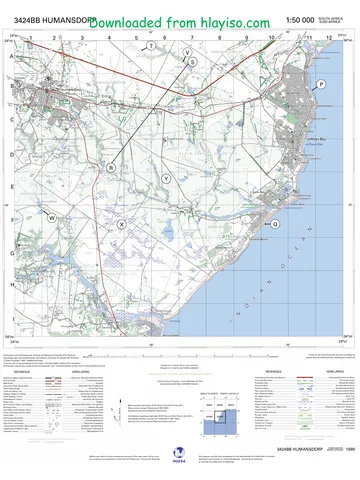
1. An extract from topographic map 3224 BA and BC GRAAFF-REINET
2. Orthophoto map 3224 BC 1 GRAAFF-REINET
3. NOTE:The resource material must be collected by the schools for their own
use.
INSTRUCTIONS AND INFORMATION
1. Write your NAME in the space provided on the cover page.
2. Answer ALL the questions in the spaces provided in this question paper.
3. You are provided with a 1 : 50 000 topographic map (3224 BA and BC
GRAAFF-REINET) and an orthophoto map (3224 BC 1 GRAAFF-REINET)
of a part of the mapped area.
4. You must hand in the topographic map and the orthophoto map to the
invigilator at the end of this examination session.
5. You must use the blank page at the back of this paper for all rough work.
DO NOT detach this page from the question paper.
6. Show ALL calculations and formulae, where applicable. Marks will be awarded
for these.
7. Indicate the unit of measurement in the final answer of calculations. Ensure
that units are maintained throughout ALL your calculations and final answer.
8. You may use a non-programmable calculator.
9. The area demarcated in RED on the topographic map represents the area
covered by the orthophoto map.
10. A glossary of some of the English and Afrikaans words and their
translations appears below.
ENGLISH AFRIKAANS
Landing strip Vliegveld
Furrow Voor
Caravan Park Karavaanpark
Canal Kanaal
Sewerage works Rioolwerke
Golf Course Gholfbaan
Excavation Uitgrawing
Nature reserve Natuurreservaat
Rifle Range Skietbaan
Aerodrome Vliegveld
Ravine Kloof
Copyright reserved Please turn over
(EC/NOVEMBER 2017) GEOGRAPHY P2 3
GENERAL INFORMATION ON GRAAFF-REINET
Graaff-Reinet is a small town in the Eastern Cape with a population of around 36 000. This
town is in the Sarah Baartman District and is one of the oldest towns in South Africa after
Cape Town, Stellenbosch and Swellendam.
Nature conservation is a priority in this area, the Camdeboo National Park almost surrounds
Graaff-Reinet. It provides the visitor with insights into the unique landscape and ecosystem
of the Karoo. Space, nature and heritage combine to offer a Karoo tourism experience.
Coordinates: 32°15′08″S 24°32′26″E / 32°15,1′S 24°32,4′E
[Source: https://www.google.co.za/images]
Copyright reserved Please turn over
4 GEOGRAPHY P2 (EC/NOVEMBER 2017)
QUESTION 1: MULTIPLE-CHOICE QUESTIONS
The questions below are based on the 1:50 000 topographic map 3224 BA & BC
GRAAFF-REINET, as well as the orthophoto map of a part of the mapped area.
Various options are provided as possible answers to the following questions. Choose
the answer and write only the letter (A–D) in the block next to each question.
1.1 The map code of the topographic map of Graaff-Reinet indicates that the town
lies on the ...
A 32ºE longitude and 24ºN latitude.
B 32ºN longitude and 24ºE latitude.
C 32ºS latitude and 24ºE longitude.
D 24ºS latitude and 32ºE longitude.
1.2 The contour interval of the orthophoto map is …
A 20 m.
B 10 m.
C 15 m.
D 5 m.
1.3 The map scales that are evident on the topographic map is a … scale.
A ratio and a word
B ratio and a fraction
C line and a ratio
D line and a word
1.4 The man-made feature at 6 on the orthophoto map is a …
A golf course.
B caravan park.
C stadium.
D parking area.
1.5 Graaff-Reinet is in the … province.
A Western Cape
B Eastern Cape
C KwaZulu-Natal
D North West
1.6 The scale of the orthophoto map is … than that of the topographic map.
A 5 times larger
B 5 times smaller
C 10 times larger
D 10 times smaller
Copyright reserved Please turn over
(EC/NOVEMBER 2017) GEOGRAPHY P2 5
1.7 The landform that is found at F in block F10 is a ...
A conical hill.
B cliff.
C mesa.
D butte.
1.8 Feature labelled G in block I2 is a …
A benchmark.
B trigonometrical station.
C spot height.
D reservoir.
1.9 The co-ordinates of the spot height 1076 in block G7 are …
A 32º15ʹ27ʹʹS 24º36ʹ16ʹʹE.
B 24º36ʹ16ʹʹS 32º15ʹ27ʹʹE.
C 32º15ʹ00ʹʹE 24º36ʹ00ʹʹS.
D 32º16ʹ00ʹʹS 24º37ʹ00ʹʹS.
1.10 Development east of Kroonvale in block G4 is limited owing to …
A a lack of transport.
B non-perennial water.
C steep terrain.
D churches.
1.11 The national route on the topographic map in block F3 is the …
A R63.
B N10.
C N7.
D N9.
1.12 The altitude shown by the trigonometric station in block F4 is …
A 13 m.
B 88 m.
C 1217,3 m.
D 1144 m.
1.13 The feature numbered 1 on the orthophoto map which acts as a windbreak is
a…
A wall.
B road.
C row of trees.
D reservoir.
Copyright reserved Please turn over
6 GEOGRAPHY P2 (EC/NOVEMBER 2017)
1.14 The type of map projection used in the topographic map is:
A Mercator
B Gauss conform
C Polar stereographic
D Central meridian
1.15 The major primary activity visible in block A3 is …
A fishing.
B mining.
C forestry.
D farming.
(15 x 1) [15]
Copyright reserved Please turn over
(EC/NOVEMBER 2017) GEOGRAPHY P2 7
SECTION B: MAPWORK CALCULATIONS AND TECHNIQUES
QUESTION 2
2.1 Interpret the map scale on the topographical map into a word scale.
(centimetres to metres)
(1 x 1) (1)
2.2 Calculate the actual straight-line distance in kilometres of the runway in block
C3. Show ALL calculations. Marks will be awarded for calculations.
Actual distance =
(3 x 1) (3)
2.2 Use the information on the topographic map, to determine the magnetic
declination for 2017. Show ALL calculations. Marks will be awarded for
calculations.
Difference in years =
=
Mean annual change =
Total change =
Magnetic declination for 2017 =
(6 x 1) (6)
Copyright reserved Please turn over
8 GEOGRAPHY P2 (EC/NOVEMBER 2017)
2.3 Calculate the average gradient on the orthophoto map between the
trigonometric station 265 south of Graaff-Reinet and the spot height 806
south of Spandauville.
Show ALL calculations. Marks will be awarded for calculations.
𝐕𝐞𝐫𝐭𝐢𝐜𝐚𝐥 𝐢𝐧𝐭𝐞𝐫𝐯𝐚𝐥 (𝐕𝐈)
Formula: Gradient = 𝐇𝐨𝐫𝐢𝐳𝐨𝐧𝐭𝐚𝐥 𝐞𝐪𝐮𝐢𝐯𝐚𝐥𝐞𝐧𝐭 (𝐇𝐄)
(5 x 1) (5)
2.4 Draw a simple cross-section from point A to point B.
Use a vertical scale of 5 mm = 50 m.
A
B
(3 x 1) (3)
2.5 Determine the true bearing of the windmill from spot height 813 in block B1.
(2 x 1) (2)
[20]
Copyright reserved Please turn over
(EC/NOVEMBER 2017) GEOGRAPHY P2 9
SECTION C
QUESTION 3: MAP AND PHOTO APPLICATION AND INTERPRETATION
3.1 What is the altitude of the following features?
3.1.1 National road in block 12:
3.1.2 Spot height D in block B11:
3.1.3 Conical Hill in Block A12:
(3 x 2) (6)
3.2 Choose the correct slope between the brackets. The type of slope that is found
between points 2 and 3 on the orthophoto map is (concave, convex, uniform)
(1 x 1) (1)
3.3 The area in block C4 on the topographic map may be described as dry with
seasonal rainfall.
Give TWO pieces of evidence to support this statement.
(2 x 2) (4)
3.4 Where do the farmers in block B3 obtain their water supply? Mention ONE
source.
(1 x 1) (1)
3.5 Graaff-Reinet has attractive landforms that are associated with igneous
intrusions. Name THREE of these landforms that appear on the topographic
map.
(3 x 1) (3)
3.6 What contour arrangement in block C3 shows that the area chosen for the
aerodrome was a suitable one for landing airplanes?
(1 x 1) (1)
Copyright reserved Please turn over
10 GEOGRAPHY P2 (EC/NOVEMBER 2017)
3.7 Study the photograph below. It shows a typical Karoo landscape similar to the
landscape in the topographic map and orthophoto map that you are using.
A B C
D
3.7.1 Is the picture above a horizontal, oblique or vertical photograph?
(1 x 1) (1)
3.7.2 Is the landscape in the photograph a natural, an agricultural or a built-
up environment?
(1 x 1) (1)
3.7.3 The landform in block 12 and the landform in block I12 and J12 are
represented by A and B respectively on the photograph above.
Identify landforms A and B.
A:
B:
(2 x 1) (2)
3.7.4 Identify the slope types labelled C and D on the photograph.
C:
D:
(2 x 1) (2)
3.8 Is Spandaukop in block H2 a protected area? Support your answer.
Answer:
Support:
(1 + 2) (3)
[25]
Copyright reserved Please turn over
(EC/NOVEMBER 2017) GEOGRAPHY P2 11
QUESTION 4: (GIS)
4.1 Write GIS in full.
(1 x 1) (1)
4.2 Identify point and line features in block C4.
Point feature:
Line feature:
(2 x 1) (2)
4.3 Between the orthophoto map and the topographic map, which one was first
captured by remote sensing techniques?
(1 x 1) (1)
4.4 Remote sensing is any technology that can capture information about a place
or an object from a distance. One can create maps of a place without being
specifically at the place.
4.4.1 Give ONE advantage of remote sensing.
(1 x 2) (2)
4.4.2 From the list below identify with a cross (X) examples of remotely
sensed data.
Data Remotely Sensed Remotely Sensed
Data Data
Yes No
1. Satellite image
2. Rock types
(2 x 1) (2)
4.5 List any TWO key components of GIS.
Components:
(2 x 1) (2)
Copyright reserved Please turn over
12 GEOGRAPHY P2 (EC/NOVEMBER 2017)
4.6
A
B C
Legend
Primary school
Secondary school N
Play school
Main road
You are a businessman and you are given three places to choose from, to
start a tuckshop business that will serve lunch for schools in Lubanzini.
Locations are shown in the map above.
4.6.1 Using the knowledge that you have gained from GIS, and choose a
suitable area from A, B or C?
(1 x 1) (1)
4.6.2 Provide TWO reasons for your choice in QUESTION 4.6.1.
(2 x 2) (4)
[15]
TOTAL: 75
Copyright reserved Please turn over
(EC/NOVEMBER 2017) GEOGRAPHY P2 13
ROUGH WORK-(do not remove this page).
Copyright reserved Please turn over
Study this subject
Revise the topics in this paper, then practise them question by question.
- Grade 10 Geography notes
CAPS revision notes with worked examples.
- Geography questions by topic
Past exam questions sorted by CAPS topic, with memos where available.
- Grade 10 Geography quizzes
Short topic quizzes with instant feedback.
- All Grade 10 Geography past papers
Past papers by year, with memos where available.
- Grade 10 past papers
More Geography and other subjects in this collection.
Recommended for this subject
More papers and memos for this grade and subject.
Question paper
Geography Grade 10 North West June 2024 Question Paper (English)
Question paper
Geography Grade 10 P1 North West November 2024 QP (Eng)
Question paper
Geography Grade 10 P2 North West November 2024 QP (Eng)
Question paper
Geography Grade 10 Gauteng March Test 2023 Question Paper (Eng)
Question paper
Geography Grade 10 Eastern Cape November 2020 Question Paper
Question paper
Geography Grade 10 Eastern Cape November 2020 Question Paper
Related documents
Question paper
Geography Grade 10 P1 National November 2017 Question Paper (Eng)
Question paper
Geography Grade 10 P2 National November 2018 Question Paper (Eng)
Memorandum
Geography Grade 10 Paper 1 National November 2017 Memo (English)
Memorandum
Geography Grade 10 Paper 2 National November 2019 Memo (English)
Question paper
Geography Grade 10 P1 Eastern Cape November 2017 QP (Eng)
Question paper
Geography Grade 10 P2 Eastern Cape November 2020 QP (Eng)
More from Grade 10 Geography
Study guide
Gr10 Geografie OG studyguide LR
Annual teaching plan
Gr 10 Geo ATP 2023 24
Question paper and memo
Geography Grade 10 Free State March Test 2025 Paper & Memo
Question paper and memo
Geography Grade 10 Paper 1 Limpopo June 2025 Paper & Memo
Question paper and memo
Geography Grade 10 Eastern Cape June 2024 Paper & Memo
Addendum