
Downloaded from hlayiso.com
NATIONAL SENIOR CERTIFICATE EXAMINATION
NOVEMBER 2018
GEOGRAPHY: PAPER II
EXAMINATION NUMBER
Time: 1½ hours 100 marks
PLEASE READ THE FOLLOWING INSTRUCTIONS CAREFULLY
1. Write your examination number in the appropriate blocks provided above.
2. This question paper consists of 15 pages, a topographic map extract, an
orthophoto map extract and a yellow equipment sheet. Please check that your
question paper is complete.
3. Read the questions carefully.
4. Answer ALL the questions in the spaces provided on the question paper.
5. Carefully study the 1:50 000 topographic map extract 2828 AB and 2828 AD
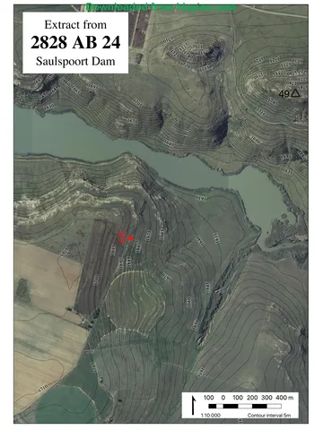
BETHLEHEM and the accompanying 1:10 000 orthophoto map extract 2828 AB 24
SAULSPOORT DAM before answering the questions.
6. The topographic map extract has grid lines with markings A to G and 1 to 12 that
may be used to identify locations according to blocks.
7. The topographic map extract, orthophoto map extract and your completed answer
book must be handed to the invigilator at the end of the examination. The maps
and photos may be retained by the school for future use.
8. On page 2 is a glossary of words. This will help you understand what the words in
bold in the questions are asking you to do.
9. The yellow equipment sheet may be used in lieu of equipment not brought to the
examination by the candidate. It may also be used for rough work. There is a fold
mark indicating where it should be folded. A magnifying glass and calculator may
be used.
10. It is in your own interest to write legibly and to present your work neatly.
FOR MARKER'S USE ONLY
Question 1 2 3 Total
Marks 44 42 14 100
Obtained
IEB Copyright © 2018 PLEASE TURN OVER
Skip to contentQuestion paper 
View all
Geography Grade 12 IEB Paper 2 2018 Question Paper
IEB Grade 12 Geography Paper 2 question paper from the 2018, 15 pages. Read online or get the free PDF download, memo linked when available.
Publisher: IEB
Geography · Grade 12 · 2018. Question paper, 15 pages. Read online or download the PDF.
- Subject
- Geography
- Grade
- Grade 12
- Document type
- Question paper
- Year
- 2018
- Paper
- 2
- Publisher
- IEB
- Curriculum
- IEB
- Pages
- 15
- File size
- 1.4 MB
Loading document…
Loading document…
1 of 15
Document textSearch extracted text and jump to a page.
Downloaded from hlayiso.com
NATIONAL SENIOR CERTIFICATE: GEOGRAPHY: PAPER II Page 2 of 15
Glossary of terms
WORD MEANING
Account for To justify and provide reasons for something using a short explanation.
Calculate To work out the value of something using a mathematical method.
Circle To draw a line around something.
Comment To give your opinion or make a statement about something, to provide an
account of. (Note: a map or diagram may be part of a description.)
Complete To add information; to add all the missing parts.
Define To give a precise meaning of.
Describe To briefly give an account of something; to explain something and give
reasons. (Note: a map or diagram may be part of a description.)
Determine To establish a conclusion after reasoning.
Draw To show by means of a sketch.
Estimate To make an approximate judgement or calculation.
Explain To describe something so that it can be understood.
Give To provide something or state something.
Justify To explain and give reasons for.
State To present information or details plainly, directly and simply, without
discussion.
Substantiate To supply evidence; to prove a point.
Tabulate To arrange or give ideas or data in a table format.
Tick To mark with a tick to indicate the chosen option.
IEB Copyright © 2018
Downloaded from hlayiso.com
NATIONAL SENIOR CERTIFICATE: GEOGRAPHY: PAPER II Page 3 of 15
Figure 1: Location Map of Bethlehem in the Free State
Bethlehem has grown rapidly as a
service centre with a good rail and
road network connecting it to
Johannesburg, Harrismith and
Bloemfontein.
The area boasts fertile land with
wheat as a major crop.
The town lies at an altitude of
1 700 m and this contributes to its
cooler climate with frosty winters and
mild summers.
[Source: Examiner]
QUESTION 1 ATLAS USE, MAP ORIENTATION AND TECHNIQUES
1.1 Refer to the location map above (Figure 1), as well as the topographic map
extract 2828 AB and 2828 AD to answer the questions that follow. Tick the
correct box.
1.1.1 The province labelled A in Figure 1 above is …
Limpopo
North West
Gauteng
Mpumalanga (1)
1.1.2 The neighbouring country labelled B in Figure 1 above is …
Swaziland
Mozambique
Lesotho
Zimbabwe (1)
1.1.3 Johannesburg is … of Bethlehem.
NE
NW
NNW
NNE (1)
IEB Copyright © 2018 PLEASE TURN OVER
Downloaded from hlayiso.com
NATIONAL SENIOR CERTIFICATE: GEOGRAPHY: PAPER II Page 4 of 15
1.1.4 The approximate distance from Bethlehem to Johannesburg is …
(use Figure 1).
200 km
225 km
275 km
300 km (1)
1.1.5 (a) The Ballyduff smallholdings (D4) rely on underground water
for irrigating their crops.
True
False (1)
(b) Justify your answer to Question 1.1.5 (a).
(2)
IEB Copyright © 2018
Downloaded from hlayiso.com
NATIONAL SENIOR CERTIFICATE: GEOGRAPHY: PAPER II Page 5 of 15
1.2 Photograph 1 was taken on the outskirts of Bethlehem on the R26 toward
Retief and Warden.
Photograph 1
[Source: Examiner's photograph]
1.2.1 Study positions 1, 2, 3 and 4 on R26 on the topographic map extract. At
which position was the photographer standing? Tick the correct option.
1
2
3
4 (2)
1.2.2 Account for your answer to Question 1.2.1 using evidence from the
topographic map extract.
(2)
1.2.3 State the direction in which Photograph 1 was taken.
(1)
1.2.4 (a) Determine whether the diggings (D4) are visible from where
the photographer stood.
Yes
No (1)
IEB Copyright © 2018 PLEASE TURN OVER
Downloaded from hlayiso.com
NATIONAL SENIOR CERTIFICATE: GEOGRAPHY: PAPER II Page 6 of 15
(b) Using evidence from the topographic map extract, account for
your answer to Question 1.2.4 (a).
(2)
1.2.5 Refer to Figure 2.
Figure 2: The gradient from A to B in Photograph 1
Using the data in Figure 2, calculate the gradient between A and B.
(a) Gradient: 1 :
Calculations:
(3)
(b) Circle the word that best describes the slope shown in Figure 2.
concave convex flat gentle steep very steep
(2)
IEB Copyright © 2018
Downloaded from hlayiso.com
NATIONAL SENIOR CERTIFICATE: GEOGRAPHY: PAPER II Page 7 of 15
1.3 Geographic techniques and orthophoto interpretation
1.3.1 Study the orthophoto map extract 2828 AB 24 SAULSPOORT DAM.
This area is covered by the purple square drawn on the topographic
map extract.
Draw a cross section on the graph paper below from position S (E8)
north of Coenana Farm to trigonometric station 49 at 1 787,4 m
(D8 and D9). A vertical scale of 1 cm : 20 m has been provided for
you.
(6)
1.3.2 Fill in and label the position of the following on the cross section:
• the Saulspoort Dam
• any road (2)
1.3.3 Determine the vertical scale of the cross section as a ratio.
1: (2)
1.3.4 Calculate the vertical exaggeration of the cross section.
times.
Calculations:
(2)
IEB Copyright © 2018 PLEASE TURN OVER
Downloaded from hlayiso.com
NATIONAL SENIOR CERTIFICATE: GEOGRAPHY: PAPER II Page 8 of 15
1.4 Photograph 2 is of a scene simulating landing a plane at Bethlehem
Aerodrome/Airport (E3 and E4). This picture shows the southern runway,
Runway ONE on the topographic map extract. Photograph 3 shows the
landing fees at Bethlehem Aerodrome/Airport.
Photograph 2 Photograph 3
[Source: <https://flyawaysimulation.com>] [Source: Examiner's photograph]
A pilot is completing the preflight information that is needed to program into
the light aircraft's (weighing 2 400 kg) GPS navigation system. Complete
the preflight checklist below with the information needed to make a
successful flight. SIX local flights will be completed during the day.
1.4.1 Number of runways at Bethlehem
Aerodrome/Airport
(1)
1.4.2 The landing cost of six trips today (1)
1.4.3 Bearing of Runway ONE (landing
in an easterly direction) (2)
1.4.4 The magnetic declination for 2018
is …
Calculations:
(2)
1.4.5 Magnetic bearing for a pilot to
land on Runway ONE in 2018
would be … (2)
1.4.6 Co-ordinates of the eastern end of S – _____° _____' _____"
Runway ONE to enter into the
GPS E – _____° _____' _____" (4)
[44]
Q1 subtotal
IEB Copyright © 2018
Downloaded from hlayiso.com
NATIONAL SENIOR CERTIFICATE: GEOGRAPHY: PAPER II Page 9 of 15
QUESTION 2 FLUVIAL PROCESSES, CLIMATE AND GEOGRAPHIC
INFORMATION SYSTEMS
2.1 Study the Fact File and Photograph 4 of the Saulspoort Dam below.
Fact File: Photograph 4
Saulspoort Dam supplies Bethlehem with
domestic water. The water level when
the dam is full is 1 627,3 m above sea
level.
The dam wall is in block D5. The water
exits north into block C5.
[Source: Department of Water and Sanitation]
2.1.1 Using information from the topographic map extract and Photograph
4, estimate from the options below what the correct bottom level is.
Hint: bottom level is the lowest point of the dam along the original
river course.
1 415 m
1 523 m
1 616 m
1 640 m (2)
2.1.2 Using evidence from Photograph 4, substantiate why the dam is at
full capacity.
(2)
IEB Copyright © 2018 PLEASE TURN OVER
Downloaded from hlayiso.com
NATIONAL SENIOR CERTIFICATE: GEOGRAPHY: PAPER II Page 10 of 15
2.2 Study the satellite photograph of the river below and the map extract of the
area just north of the dam wall and the Skulpspruit Farm in C5 and C6
indicated by Y on the photograph.
Photograph 5: Skulpspruit Farm, Bethlehem
[Source: Google Earth]
2.2.1 What type of fluvial feature is evident at X in Photograph 5? Tick the
correct option.
Waterfall
Meander
Oxbow lake
Paired terraces (2)
2.2.2 (a) Is the river at peak flow in this image? Circle the correct
answer.
YES / NO (1)
IEB Copyright © 2018
Downloaded from hlayiso.com
NATIONAL SENIOR CERTIFICATE: GEOGRAPHY: PAPER II Page 11 of 15
(b) Substantiate your answer with evidence from Photograph 5
and the topographic map extract.
(4)
2.3 Describe why the farm buildings at Skulpspruit (located at Y on
Photograph 5) are located in an ideal microclimatic position.
(6)
2.4 Study the tributaries of the Liebenbergsvlei River in blocks F11 and F12 of
the topographic map extract. Figure 3 is a GIS-generated map of the same
area showing the rivers and erosion.
Figure 3
IEB Copyright © 2018 PLEASE TURN OVER
Downloaded from hlayiso.com
NATIONAL SENIOR CERTIFICATE: GEOGRAPHY: PAPER II Page 12 of 15
2.4.1 Calculate the area of the drainage basin indicated by the dotted line
in Figure 3.
Area: m2
Calculations:
(4)
2.4.2 Circle the type of data evident on this GIS-generated map (Figure 3).
Vector Raster
(2)
2.4.3 Circle THREE types of attribute data that best describe the
Liebenbergsvlei River tributaries found in blocks F11 and F12.
Perennial Non-perennial Episodic Periodic
Exotic Dendritic Parallel Haphazard
(3)
2.4.4 Give ONE possible reason for the erosion evident in F11.
(2)
2.4.5 A dotted line shows the drainage basin of this system in Figure 3.
Define the term drainage basin.
(2)
2.5 Circle the correct underlined word to complete the sentence below.
The drainage density of the stream network in Figure 3 could be described
as high / medium / low and the river's texture could be described as
medium / coarse / fine. (2)
IEB Copyright © 2018
Downloaded from hlayiso.com
NATIONAL SENIOR CERTIFICATE: GEOGRAPHY: PAPER II Page 13 of 15
2.6 2.6.1 Tabulate the stream orders of the rivers in the drainage basin in
Figure 3 in the table below.
Stream order 1 2 3
Number of streams (6)
2.6.2 Comment on how stream ordering can be used as a predictor of
flooding.
(4)
[42]
Q2 subtotal
IEB Copyright © 2018 PLEASE TURN OVER
Downloaded from hlayiso.com
NATIONAL SENIOR CERTIFICATE: GEOGRAPHY: PAPER II Page 14 of 15
QUESTION 3 SETTLEMENT AND THE ECONOMY
Study the topographic map extracts in Figures 4 and 5 below.
Figure 4 – Land use around Loch Lomond Figure 5 – Land use around Loch Lomond
3.1 Refer to the map extracts above. Which is the more recent map of the area,
Figure 4 or Figure 5? Explain your answer.
(4)
IEB Copyright © 2018
Downloaded from hlayiso.com
NATIONAL SENIOR CERTIFICATE: GEOGRAPHY: PAPER II Page 15 of 15
3.2 Referring to Figure 4, draw a land-use sketch map for the area in
Bethlehem. Use the template provided below. It must have a legend or key.
Legend or Key
Features Symbol
Railway lines
Roads
Bodies of water
Buildings (use topographic symbols)
Other features (10)
[14]
Q3 subtotal
Total: 100 marks
IEB Copyright © 2018
Study this subject
Revise the topics in this paper, then practise them question by question.
- Grade 12 Geography notes
CAPS revision notes with worked examples.
- Geography questions by topic
Past exam questions sorted by CAPS topic, with memos where available.
- Grade 12 Geography quizzes
Short topic quizzes with instant feedback.
- All Grade 12 Geography past papers
Past papers by year, with memos where available.
- Grade 12 IEB past papers
More Geography and other subjects in this collection.
Recommended for this subject
More papers and memos for this grade and subject.
Question paperIEB
Geography Grade 12 IEB Paper 1 2019 Question Paper
Question paperIEB
Geography Grade 12 IEB Paper 1 2019 Question Paper (Afrikaans)
Question paperIEB
Geography Grade 12 IEB Paper 1 2019 Question Paper (Afrikaans)
Question paperIEB
Geography Grade 12 IEB Paper 2 2019 Question Paper
Question paperIEB
Geography Grade 12 IEB Paper 2 2019 Question Paper (Afrikaans)
Question paperIEB
Geography Grade 12 IEB Paper 2 2019 Question Paper (Afrikaans)
Related documents
Question paperIEB
Geography Grade 12 IEB Paper 2 2018 Question Paper
MemorandumIEB
Geography Grade 12 IEB Paper 2 2018 Memo
Question paperIEB
Geography Grade 12 IEB Paper 1 2018 Question Paper
Question paperIEB
Geography Grade 12 IEB Paper 2 2019 Question Paper
Question paperIEB
Geography Grade 12 IEB Paper 2 2017 Question Paper
Question paperIEB
Geography Grade 12 IEB Paper 2 2017 Question Paper
More from Grade 12 Geography
MemorandumIEB
Geography Grade 12 IEB Paper 1 2019 Memo
MemorandumIEB
Geography Grade 12 IEB Paper 2 2019 Memo
MemorandumIEB
Geography Grade 12 IEB Paper 1 2018 Memo
MemorandumIEB
Geography Grade 12 IEB Paper 1 2018 Memo
AddendumIEB
Geography Grade 12 IEB Paper 1 2018 Addendum
Question paperIEB