
Downloaded from hlayiso.com
NATIONAL SENIOR CERTIFICATE EXAMINATION
NOVEMBER 2019
GEOGRAPHY: PAPER II
MARKING GUIDELINES
Time: 1½ hours 100 marks
These marking guidelines are prepared for use by examiners and sub-examiners,
all of whom are required to attend a standardisation meeting to ensure that the
guidelines are consistently interpreted and applied in the marking of candidates'
scripts.
The IEB will not enter into any discussions or correspondence about any marking
guidelines. It is acknowledged that there may be different views about some
matters of emphasis or detail in the guidelines. It is also recognised that,
without the benefit of attendance at a standardisation meeting, there may be
different interpretations of the application of the marking guidelines.
IEB Copyright © 2019 PLEASE TURN OVER
Skip to contentMemorandum 
View all
Geography Grade 12 IEB Paper 2 2019 Memo
IEB Grade 12 Geography Paper 2 memorandum from the 2019, 17 pages. Read online or get the free PDF download, question paper linked when available.
Publisher: IEB
Geography · Grade 12 · 2019. Memorandum, 17 pages. Read online or download the PDF.
- Subject
- Geography
- Grade
- Grade 12
- Document type
- Memorandum
- Year
- 2019
- Paper
- 2
- Publisher
- IEB
- Curriculum
- IEB
- Pages
- 17
- File size
- 883.8 KB
Loading document…
Loading document…
1 of 17
Document textSearch extracted text and jump to a page.
Downloaded from hlayiso.com
NATIONAL SENIOR CERTIFICATE: GEOGRAPHY: PAPER II – MARKING GUIDELINES Page 2 of 17
Figure 1 – Location map of Underberg in KwaZulu-Natal
Underberg is situated in
the foothills of the
southern Drakensberg in
KwaZulu-Natal. It is an
administrative service
centre with dairy and
cattle farming as its major
economic activities.
Tourism is the second-
largest contributor to the
economy with Underberg
being the gateway to the
southern Drakensberg and
being the host of Splashy
Fen, one of South Africa's
premier music festivals.
Underberg also serves as a
trading centre for the
people of Lesotho who
use Sani Pass to enter
South Africa.
[Source: Examiner]
QUESTION 1 ATLAS USE, MAP ORIENTATION AND TECHNIQUES
1.1 Refer to the location map above (Figure 1), as well as the topographic map extract
2929CB, 2929CD, 2929DA and 2929DC, UNDERBERG to answer the questions
that follow. Tick the correct box.
1.1.1 The river labelled A in Figure 1 above is the … River.
Fish
Orange
Thukela
Mzimkhulu X
1.1.2 The major port labelled B in Figure 1 above is …
Nqura
Durban
Saldanha X
Cape Town
IEB Copyright © 2019 PLEASE TURN OVER
Downloaded from hlayiso.com
NATIONAL SENIOR CERTIFICATE: GEOGRAPHY: PAPER II – MARKING GUIDELINES Page 3 of 17
1.1.3 The province labelled C in Figure 1 is …
KwaZulu-Natal
North West
Eastern Cape X
Western Cape
1.1.4 The Sani Pass Border Control (A2/3) is roughly 42 km from Underberg. It is
the border between South Africa and …
Lesotho X
Zimbabwe
Swaziland
Botswana
1.1.5 The length of the river marked A in Figure 1 is approximately …
100 km
175 km X
250 km
375 km
1.1.6 The river marked A in Figure 1 flows in a … direction.
south-easterly X
north-westerly
southerly
east-south-easterly
1.1.7 The Splashy Fen Musical Festival is an example of a … economic activity.
primary
secondary
tertiary X
quaternary
1.1.8 The central meridian on the topographic map extract is 29 °E.
True X
False
IEB Copyright © 2019 PLEASE TURN OVER
Downloaded from hlayiso.com
NATIONAL SENIOR CERTIFICATE: GEOGRAPHY: PAPER II – MARKING GUIDELINES Page 4 of 17
1.1.9 The Lesotho Highlands Water Transfer Scheme provides most of
Gauteng's water by pumping water from Lesotho into the Vaal River
system.
True X
False
1.1.10 The river labelled A in Figure 1 flows into the Atlantic Ocean.
True
False X
1.2 The map extract provided is a composite of four maps covering Underberg and the
surrounding areas (2929CB, 2929CD, 2929DA and 2929DC) and is shown below in
grid format.
Estcourt
29 °E 30 °E
29 °S
UNDERBERG
30 °S
1.2.1 Indicate with a dot and label where Underberg – 2929CD is found.
(No need to use a dot or a label, any indication acceptable.)
1.2.2 Using the information provided on the grid above, give the map code for
Estcourt.
2829 DD
(1 for latitude, 1 for longitude, 1 for D and 1 for second D)
Each mark can be marked separately.
IEB Copyright © 2019 PLEASE TURN OVER
Downloaded from hlayiso.com
NATIONAL SENIOR CERTIFICATE: GEOGRAPHY: PAPER II – MARKING GUIDELINES Page 5 of 17
1.3 The following information on the display of a smart watch shows a hike in the
Mkhomazi Wilderness Area from Cobham Camp (E2) to Ngwenya Cave (B2). The
exact hiking route is highlighted in orange in Figure 2 and on the topographic map
extract.
Figure 2 – Hiking information from a smart watch
1.3.1 Calculate the gradient of the hike.
(a) Height difference: Cobham: 1 640 m – 1 620 m
Ngwenya: 1 820 m – 1 780 m
140 m – 200 m (accept anywhere in between)
The distance from Cobham to Ngwenya (refer to Figure 2 ONLY) is 7,25 km.
(b) Gradient 1: accept anywhere between 1:36,3 and 1:51,8.
Calculations
Height 140 200
Gradient =
Distance 7 250 7 250
= 51, 8 = 36, 3
(method mark is given for converting 7,25 km into 7 250 m ONLY)
IEB Copyright © 2019 PLEASE TURN OVER
Downloaded from hlayiso.com
NATIONAL SENIOR CERTIFICATE: GEOGRAPHY: PAPER II – MARKING GUIDELINES Page 6 of 17
1.3.2 (a) Draw a sketch cross section on the axes below, from Cobham Camp
to Ngwenya Cave along the orange line (the hiking trail) indicated.
Ngwenya
Cave
3 clear sections must be seen
Cobham
Camp
(1 mark for each level. Unifrom concave slope can be awarded max
2 marks. Award 1 mark for a start and/or end at correct height.
Uniform slope with height can be awarded 3 marks)
(b) Is Ngwenya Cave visible from Cobham Camp?
Yes
No X
1.3.3 Using the topographic map extract, choose the most appropriate true
bearing from Cobham Camp to Ngwenya Cave.
84°
174°
264°
354° X
1.3.4 The magnetic declination for the topographic map extract for 2019 is …
24° 15' W
25° 51' W
24° 36' W
24° 51' W X
Calculations
24° 15' in 2015, change is 4 years @ 9' W pa = 36'
Plus 36' = 24° 51' W of TN
(NOTE: no method marks awarded here)
IEB Copyright © 2019 PLEASE TURN OVER
Downloaded from hlayiso.com
NATIONAL SENIOR CERTIFICATE: GEOGRAPHY: PAPER II – MARKING GUIDELINES Page 7 of 17
1.3.5 Consider a hiker using a conventional compass. Calculate the magnetic
bearing for the hike from Cobham Camp to Ngwenya Cave for 2019.
018° 51'
Calculations: MB = TB + MD
354° + 24° 51' = 018° 51'
(Method mark can be awarded if a MB and TB are added together. If
no calculation is shown, but 378° 51’ is given as answer, only award 1
method mark. If ONLY 378° is given, NO mark is awarded)
1.3.6 Provide the coordinates for Ngwenya Cave (use the symbol on topographic
map extract).
Latitude – 29 ° 39 ' 20 "S (accept 17–25'')
Longitude – 29 ° 24 ' 25 "E (accept 21–28'')
(Minutes and seconds awarded marks. If latitude is wrong, the minutes
and seconds (even if correct) cannot be awarded marks as it is the
wrong position)
IEB Copyright © 2019 PLEASE TURN OVER
Downloaded from hlayiso.com
NATIONAL SENIOR CERTIFICATE: GEOGRAPHY: PAPER II – MARKING GUIDELINES Page 8 of 17
1.4 PHOTO ANALYSIS
Study Photograph 1 below showing the view the hiker had of the Sani Pass Hotel
and Golf Course during the hike. This is taken from position E on the topographic
map extract.
Photograph 1 – View of the Sani Pass Hotel
[Source: Examiner's photo]
1.4.1 (a) The photograph shown above is an example of a …
vertical photograph
high oblique photograph X
low oblique photograph
false colour photograph
(b) Provide ONE advantage of this type of photograph.
Specific to oblique photo – A large area can be photographed.
Relief is quite easy to identify.
Height differences can be seen.
Colour photo shows clear, real-life detail.
Horizon only – no marks
1.4.2 (a) During which season do you think this photo was taken?
Winter X
Summer
IEB Copyright © 2019 PLEASE TURN OVER
Downloaded from hlayiso.com
NATIONAL SENIOR CERTIFICATE: GEOGRAPHY: PAPER II – MARKING GUIDELINES Page 9 of 17
(b) Provide one reason, using photographic evidence, for your answer to
Question 1.4.2 (a).
The photograph shows the landscape being very brown and dry.
This area gets very little rain in winter and the frequent frosts "kill"
the grass.
River is low, floodplain evident
Fire breaks evident in photo
1.4.3 State the direction the photographer was facing when the photograph was
taken.
NE or ENE or E
1.4.4 The picture shows the Mkhomazana River that flows past the hotel.
Evidence in this picture proves that the river is in its middle course.
Circle the features in the block below that support this statement.
meandering superimposed drainage flat land
rejuvenation turbulent flow
(If 3 are circled with 2 out of 3 correct, award max 1 mark. If 4 or 5 circled –
no marks awarded)
IEB Copyright © 2019 PLEASE TURN OVER
Downloaded from hlayiso.com
NATIONAL SENIOR CERTIFICATE: GEOGRAPHY: PAPER II – MARKING GUIDELINES Page 10 of 17
QUESTION 2 THEMATIC MAPS, AERIAL PHOTOGRAPH, FLUVIAL
PROCESSES, VALLEY CLIMATES AND
GEOGRAPHIC INFORMATION SYSTEMS
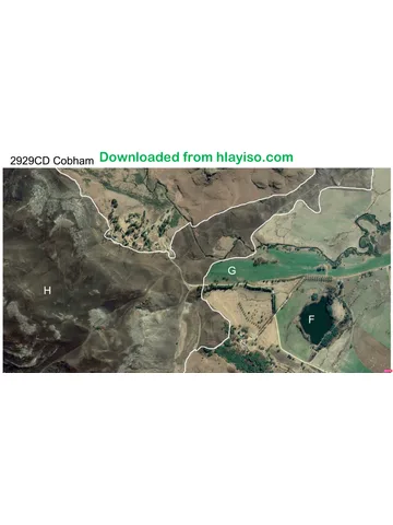
2.1 Study the aerial photograph 2929CD of Cobham (E2).
2.1.1 At approximately what time was the photograph taken?
06:00
10:00 X
14:00
18:00
2.1.2 Provide a reason for your answer above using photographic evidence.
Shadows are being cast on the south-western/western side of trees, therefore
sun is in the east. 06:00 is too early for these shadows: they would have been
longer. Reference must be made to the photo showing shadows in W/SW
direction, not just sun rising in the east (this isn’t visible on the photo).
2.2 Three features / land use (F, G and H) are labelled on the photograph. Identify them.
F – Timber Dam or Dam only, perennial water, lake also accepted.
G – Cultivated land / farmland / agricultural land also accepted.
H – A fire break or any reference to burning (white outlined polygon shape), or
Mkomazi protected area/ nature reserve or hiking trail.
IEB Copyright © 2019 PLEASE TURN OVER
Downloaded from hlayiso.com
NATIONAL SENIOR CERTIFICATE: GEOGRAPHY: PAPER II – MARKING GUIDELINES Page 11 of 17
2.3 Study Figure 3 below of the Trout Beck River drainage basin (it has been marked
with a purple outline on the topographic map extract). This river drains into the
Pholela River further south. Answer the question below.
Figure 3 – Trout Beck River drainage basin
There is one dominant drainage pattern evident in this basin. Circle the words in the
list below that best describe the rivers evident in this drainage basin.
deranged perennial dendritic
radial trellis non-perennial
(If 3 are circled with 2 out of 3 correct, award max 1 mark. If 4 or 5 circled –
no marks awarded)
2.4 2.4.1 Describe the drainage density and texture of this river system.
Density: the density is high/ medium density with many first order streams in
the drainage basin.
Texture: Fine.
2.4.2 Identify ONE factor, evident on the topographical map, which could give
rise to this type of drainage density and texture.
Relief is steep/mountains/contours close together, leading to runoff and
higher density.
Slopes are most likely grassy or hard/impermeable/resistant leading to
runoff and higher density.
IEB Copyright © 2019 PLEASE TURN OVER
Downloaded from hlayiso.com
NATIONAL SENIOR CERTIFICATE: GEOGRAPHY: PAPER II – MARKING GUIDELINES Page 12 of 17
2.5 Study the stream ordering table below of the Trout Beck River system.
Stream Order 1 2 3 4
Number of 26 5 2 1
Calculate the bifurcation ratio for this river system. 3.2
Calculations
26/5 = 5,2
5/2 = 2,5 all three orders calculated correctly for 1 mark
2/1 = 2
5,2 + 2,5 + 2 = 9,7 all three orders added up correctly for 1 mark
9.7 / 3 (total to be divided by 3 for 1 mark) = 3,2
MAX 3 method marks if answer above is incorrect.
If answer above is 3, look for method marks. For 4 marks 3.2 must be given
2.6 2.6.1 The hiker mentioned in Question 1.3 spent the evening in the cave. At
around 04:00 a bitterly cold wind was felt in the cave.
Describe the site of the cave on the topographical map extract.
The cave is midway up the slope of a valley. Close to water source. Aspect
– reference to north-facing slope. Located in the thermal belt/inversion
layer. On the side of a steep mountain.
2.6.2 (a) Name the wind that was likely to have been experienced by the hiker
in the cave mentioned in Question 2.6.1. Choose the correct
answer.
Anabatic
Katabatic X
Berg
Upslope
(b) Account for the direction of these winds using topographic map
evidence.
The cave is halfway up the slope/valley and therefore the winds will
blow down the slope and pass through the cave at night. (Reference
must be made to the position of the cave with air moving down the
slope.)
IEB Copyright © 2019 PLEASE TURN OVER
Downloaded from hlayiso.com
NATIONAL SENIOR CERTIFICATE: GEOGRAPHY: PAPER II – MARKING GUIDELINES Page 13 of 17
2.7 Account for the snow on the peaks of the mountains in photograph 2 below. The
photograph is taken from position "I" on the topographic map extract. Provide ONE
climatological reason.
Peaks are at higher altitude and therefore precipitation turns to snow.
The scenario is in winter with colder temps at high altitude.
Reference could be made to a passing cold front but there must be reference to
snow falling at higher altitudes.
Photograph 2 – snow-covered peaks at position I
[Source: Examiner's photo]
2.8 Study photograph 3 below of Hazeldene (at J in D8).
Photograph 3 – Hazeldene
[Source: Examiner's photo]
2.8.1 Name the climatological feature clearly evident in photograph 3 above.
Radiation fog, fog, temp inversion or mist
IEB Copyright © 2019 PLEASE TURN OVER
Downloaded from hlayiso.com
NATIONAL SENIOR CERTIFICATE: GEOGRAPHY: PAPER II – MARKING GUIDELINES Page 14 of 17
2.8.2 With the aid of an annotated sketch, show how this feature develops.
TWO valid points (there must be reference to cold air at the bottom of the
valley meeting warmer air that has been displaced then reaching
condensation point in the form of fog. Evidence of a thermal belt/temp
inversion).
2.9 The following information is taken from the Advanced Fire Information Systems
(AFIS) website (Figure 4 below). It uses remote sensing to show fires in the
Underberg area. Photograph 4 below shows a fire burning close to farmland in B5.
Figure 4 – AFIS viewer showing low intensity fires for 17 August 2018
[Source: <https://southernafrica.afis.co.za/>]
IEB Copyright © 2019 PLEASE TURN OVER
Downloaded from hlayiso.com
NATIONAL SENIOR CERTIFICATE: GEOGRAPHY: PAPER II – MARKING GUIDELINES Page 15 of 17
Photograph 4 – Fire evident on the Sani Pass Road at B5
[Source: Examiner's photo]
2.9.1 The base map used in the AFIS viewer is an example of ... (circle the
correct answer).
raster data / vector data
2.9.2 AFIS also has an application for smart phones. Analyse how local dairy and
cattle farmers can use the app, along with other weather-related apps, to
help contain fires in their area?
Farmer can instantly view any runaway fires and check to see if they are in the
vicinity of their farms. By checking weather-related apps and looking at wind
direction (as an example) they are able to see whether the fire will spread in
their direction. They could also use this map to plan the burning of firebreaks
or to see where the closest water point is to help fight fires. Weather apps
could be used to identify days when fire could potentially break out (berg wind
etc.) and to take associated preventative measures.
Reference to two developed points can be awarded 2 × 2 = 4 or 4 simple
points 4 × 1 = 4.
Answer does not need to refer to AFIS directly, it can relate to only other
weather apps.
IEB Copyright © 2019 PLEASE TURN OVER
Downloaded from hlayiso.com
NATIONAL SENIOR CERTIFICATE: GEOGRAPHY: PAPER II – MARKING GUIDELINES Page 16 of 17
QUESTION 3 LOCAL ECONOMY, SETTLEMENT
3.1 There are two clear built-up areas on this topographic map extract – Underberg
(J7) and Himeville (G/H8). Complete the table below.
Underberg Himeville
town local service centre
3.1.1 Classification on
(could also say major (could also say minor
urban hierarchy
country town) country town)
3.1.2 Dominant street linear, could accept grid
irregular
pattern iron or rectangular
high
medium
high
3.1.3 Population
low
density (circle the medium
most likely)
Low could also be
low
accepted here based on
the shading in the
conventional symbols/key
churches
school
post office police station
3.1.4 Services available recreational ground post office
(use map golf course recreational ground
evidence train station (rail services) landing strip
available) cemetery cemetery
communications tower for (any one)
cell phone services
(any one)
primary (farming or
forestry)
3.1.5 Dominant tertiary (tourism/ primary (farming/forestry)
economic activity trading centre/ tertiary (tourism)
admin service centre)
IEB Copyright © 2019 PLEASE TURN OVER
Downloaded from hlayiso.com
NATIONAL SENIOR CERTIFICATE: GEOGRAPHY: PAPER II – MARKING GUIDELINES Page 17 of 17
3.2 Study the photographs in the table below taken around the Underberg and
Himeville areas and state whether the accompanying statements are true or false.
NB – Provide a reason if your answer is false, or a supporting fact if it is true.
Statement True / False + reason
3.2.1 Tarring the Sani
Pass road (currently TRUE – they will lose
4×4 only) (A3) will business as normal
negatively impact sedans will be able to
on tourism use the road. People
businesses like won't need guided
Sani Pass Tours drives.
(who does 4×4
tours up the pass).
3.2.2 Goxhill Farm (G/H
9/10) is an example FALSE – extensive
of intensive commercial dairy
subsistence farming.
farming.
3.2.3 Underberg serves TRUE – yes, people in
the local area as a the surrounding area
service centre. are drawn to Underberg
to provide them with
daily services and retail
goods.
3.2.4 The KFC in TRUE – this is a less-
Underberg is an specialised function
example of a lower found in settlements of
order service. all sizes drawing a
smaller threshold
population and smaller
range.
3.2.5 This settlement at FALSE – the Goxhill
Goxhill (G10) is an settlement rely on
example of market subsistence farming for
gardening. their own products.
Answer could also
reference extensive
commercial farming
taking place around
Goxhill. (Question
refers to 'settlement at
Goxhill'). The
settlement has dry,
barren lands therefore
most likely subsistence
[Source: Examiner's photos]
Total: 100 marks
IEB Copyright © 2019
Study this subject
Revise the topics in this paper, then practise them question by question.
- Grade 12 Geography notes
CAPS revision notes with worked examples.
- Geography questions by topic
Past exam questions sorted by CAPS topic, with memos where available.
- Grade 12 Geography quizzes
Short topic quizzes with instant feedback.
- All Grade 12 Geography past papers
Past papers by year, with memos where available.
- Grade 12 IEB past papers
More Geography and other subjects in this collection.
Recommended for this subject
More papers and memos for this grade and subject.
MemorandumIEB
Geography Grade 12 IEB Paper 1 2019 Memo
MemorandumIEB
Geography Grade 12 IEB Paper 1 2018 Memo
MemorandumIEB
Geography Grade 12 IEB Paper 2 2018 Memo
MemorandumIEB
Geography Grade 12 IEB Paper 1 2018 Memo
MemorandumIEB
Geography Grade 12 IEB Paper 1 2017 Memo
MemorandumIEB
Geography Grade 12 IEB Paper 2 2017 Memo
Related documents
Question paperIEB
Geography Grade 12 IEB Paper 2 2019 Question Paper
Question paperIEB
Geography Grade 12 IEB Paper 2 2019 Question Paper (Afrikaans)
Question paperIEB
Geography Grade 12 IEB Paper 2 2019 Question Paper (Afrikaans)
Question paperIEB
Geography Grade 12 IEB Paper 2 2019 Question Paper
MemorandumIEB
Geography Grade 12 IEB Paper 2 2016 Memo
Question paperIEB
Geography Grade 12 IEB Paper 1 2019 Question Paper
More from Grade 12 Geography
Question paperIEB
Geography Grade 12 IEB Paper 1 2019 Question Paper (Afrikaans)
Question paperIEB
Geography Grade 12 IEB Paper 1 2019 Question Paper (Afrikaans)
Question paperIEB
Geography Grade 12 IEB Paper 1 2018 Question Paper
Question paperIEB
Geography Grade 12 IEB Paper 2 2018 Question Paper
AddendumIEB
Geography Grade 12 IEB Paper 1 2018 Addendum
Question paperIEB