
Downloaded from hlayiso.com
NATIONAL SENIOR CERTIFICATE EXAMINATION
NOVEMBER 2017
GEOGRAPHY: PAPER I
MARKING GUIDELINES
Time: 3 hours 300 marks
These marking guidelines are prepared for use by examiners and sub-examiners,
all of whom are required to attend a standardisation meeting to ensure that the
guidelines are consistently interpreted and applied in the marking of candidates'
scripts.
The IEB will not enter into any discussions or correspondence about any marking
guidelines. It is acknowledged that there may be different views about some
matters of emphasis or detail in the guidelines. It is also recognised that,
without the benefit of attendance at a standardisation meeting, there may be
different interpretations of the application of the marking guidelines.
IEB Copyright © 2017 PLEASE TURN OVER
Skip to contentMemorandum 
View all
Geography Grade 12 IEB Paper 1 2017 Memo
IEB Grade 12 Geography Paper 1 memorandum from the 2017, 18 pages. Read online or get the free PDF download, question paper linked when available.
Publisher: IEB
Geography · Grade 12 · 2017. Memorandum, 18 pages. Read online or download the PDF.
- Subject
- Geography
- Grade
- Grade 12
- Document type
- Memorandum
- Year
- 2017
- Paper
- 1
- Publisher
- IEB
- Curriculum
- IEB
- Pages
- 18
- File size
- 974.1 KB
Loading document…
Loading document…
1 of 18
Document textSearch extracted text and jump to a page.
Downloaded from hlayiso.com
NATIONAL SENIOR CERTIFICATE: GEOGRAPHY: PAPER I – MARKING GUIDELINES Page 2 of 18
SECTION A GEOGRAPHICAL ISSUES
QUESTION 1 GEOGRAPHICAL CASE STUDY: FOCUS ON THE
BRAAMFONTEIN SPRUIT, JOHANNESBURG, GAUTENG
1.1 Geographical Information Systems
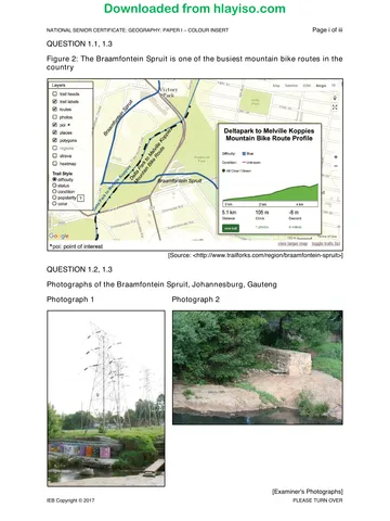
1.1.1 Delta Park to Melville Koppies Mountain Bike Route/Melville Koppies
Route/Delta Park Route/Braamfontein Spruit Route
1.1.2 • Trail labels
• Routes
• POI (points of interest)
• Places
• Polygons
• Difficulty (Trail style)
(Any 2)
1.1.3 • Gradient of the route (105 m climb)
• Distance of the route (1,5 km)
• Level of difficulty (blue)
• Descent (–8 metres)
• Condition – unknown
• View trail (1 photo, video)
• Route
If candidate only writes numbers – not accepted
(Reference to any 2 points)
1.1.4 • A mountain biker is able to plan his/her cycle effectively.
• The cyclist would be able to determine whether his/her level of
fitness is suitable for the route.
• Plan how long the ride may take, based on distance, gradient and
level of difficulty.
(Any appropriate response, 2 points provided – must have some link
to gradient/distance/level of difficulty)
1.1.5 (a) • Bicycle repair and service centres, bicycle clothing/
accessories
• Specialist Bicycle shops, e.g. Cycle Lab
• Coffee shops for cyclists to meet afterwards for coffee/
breakfast
• Gyms/training centre
• Fencing companies – for security of cycling areas
• Security personnel
• Mobile refreshment stations
• Tourism opportunities
• Bicycle factory/manufacturing of parts
• Bike Parks
• Entrance Fees
• Security/fencing of parks
• Mobile water points
• Medical facilities
(Any 2 appropriate examples)
IEB Copyright © 2017 PLEASE TURN OVER
Downloaded from hlayiso.com
NATIONAL SENIOR CERTIFICATE: GEOGRAPHY: PAPER I – MARKING GUIDELINES Page 3 of 18
(b) • Bicycle repair and service centres – tertiary
• Specialist bicycle shops – tertiary
• Coffee shops for cyclists to meet afterwards for coffee/
breakfast – tertiary
• Gyms – tertiary
• Bicycle factory/manufacturing of parts – secondary
• Water sales – informal
(Note: both examples are likely to be tertiary. Candidates are
able to earn 4 marks, even if both examples relate to tertiary
activities, if candidate only writes tertiary a max of marks are
awarded)
1.2 Drainage systems, catchment and river management
1.2.1 (a) The water flowing overland when the soil is saturated and the
ground impermeable is referred to as surface runoff.
(b) The process of altering a river channel to improve flow is
referred to as: canalisation.
(c) The point where a river originates from, normally in the form of
a natural spring is called: the source.
1.2.2 • Outspan Spruit
• Montgomery Spruit
(Note: Canal is not an acceptable answer.)
1.2.3 Emmarentia Dam (not Delta Park)
1.2.4 • Canalisation of the natural river channel.
• Extension of the drainage basin network via the storm water
drains.
• Increased number of impermeable surfaces increasing runoff in
the drainage basin – increased runoff and blockage of river
channel due to rubbish is also linked with urban development and
expansion.
• Installation of weirs.
• Power lines too close to river channel.
• Installation of bridges across the river.
• Flow intercepted/blocked by rubbish
• Dam will have impacted upon volume and velocity downstream
(Any 3) (Accept other relevant suggestions; responses must refer
directly to channel flow, changes to water pH and chemicals in
water do not address this question.)
1.2.5 • Base flow labelled (2 marks)
• Lag time, must be short, from max rainfall to peak discharge;
rainfall graph must be drawn for full 2 marks to be awarded; if no
rainfall graph only 1 mark awarded (2 marks)
• Peak discharge – must be distinct (2 marks)
• 2 marks awarded for an accurate, well-drawn graph with axes
correctly labelled (x- time, y- discharge) axis (1 mark) Shape of
graph (1 mark)
IEB Copyright © 2017 PLEASE TURN OVER
Downloaded from hlayiso.com
NATIONAL SENIOR CERTIFICATE: GEOGRAPHY: PAPER I – MARKING GUIDELINES Page 4 of 18
[Source: Ace Geography]
1.2.6 • Blocked drains will result in an increase in surface runoff/
flooding. (2 marks)
• This will cause a decrease in discharge initially until the runoff
makes its way into the river system. (2 marks)
• Must have Discharge AND Runoff.
• Increase/decrease in surface runoff (1 mark) explained (1 mark)
• Increased/decreased discharge (1 mark) explained (1 mark)
1.3 Urban structure and land use
1.3.1 Greenbelt/recreational zone/suburban/residential/park/public space
1.3.2 • Jan Smuts Ave
• William Nicol Drive
• Witkoppen Road
• M7
1.3.3 The Spruit area is an important 'Green lung' or greenbelt area in an
otherwise very built-up area of Johannesburg (2 marks). It provides
ample open space for walkers, runners and cyclists to enjoy fresh air
and outdoor life in an urban area (2 marks).
Biodiversity corridor.
(Any 2 appropriate points – mention of Greenbelt/green lung/
recreation to get full 4 marks.)
(Can elaborate fully on 1 point to get 4 marks)
1.4 The Informal Sector and Urban Settlement Issues
• A description of the work typically performed by waste pickers
Waste pickers are people who search through urban rubbish bins and
remove recyclable material such as plastic and glass which they take to
various recycling depots across the city in exchange for a small
payment. Informal, unregulated.
IEB Copyright © 2017 PLEASE TURN OVER
Downloaded from hlayiso.com
NATIONAL SENIOR CERTIFICATE: GEOGRAPHY: PAPER I – MARKING GUIDELINES Page 5 of 18
• Challenges waste pickers face on a daily basis
‒ Discrimination by higher-income earners.
‒ Repercussions/negative reactions from residents.
‒ Health hazards – toxic and dangerous waste.
‒ Irregular income, fluctuating prices/money paid to waste pickers for
recyclable material.
‒ Differing volumes of waste available according to time of the
year/month, i.e. Festive season – waste may increase.
‒ Waste needs to be transported a fair distance – this is hugely
challenging.
‒ No formal working/sorting premises – laws/regulations.
‒ Long working hours.
‒ No workers' benefits.
‒ Exposed to the elements and criminals.
‒ Transport challenges.
‒ Very physically taxing task.
‒ Face danger on city roads as drivers are reckless and may knock
over or bump into a waste picker.
‒ Cartels in operation.
(Credit other relevant points.)
• The importance of waste picking to the informal sector of South
Africa's economy
‒ People are earning a small income through this process and are able
to support a family (up to R120 earned per day).
‒ Waste pickers may be able to resell some of the items collected
further contributing to their income.
‒ Waste pickers may start up their own informal recycling depot/
centres.
‒ Unemployment levels will reduce.
‒ Alternative forms of employment are generated through the
recycling/waste picking industry – this will assist in crime reduction.
‒ Contribute to environmental sustainability.
(Credit other relevant points.)
• The positive role waste pickers play in the environmental
sustainability of urban areas in southern Africa.
These individuals play an important role in reusing and recycling
products, and hence reducing the amount of waste that goes to the
various landfills.
Cities are also cleaned up through the process – storm water drains,
river/park areas.
Reduction in pressure on landfill sites.
Contribute to environmental sustainability.
Limit the spread of disease.
(Any relevant point – focus must be on urban centres)
See detailed marking rubric – mark accordingly
IEB Copyright © 2017 PLEASE TURN OVER
Downloaded from hlayiso.com
NATIONAL SENIOR CERTIFICATE: GEOGRAPHY: PAPER I – MARKING GUIDELINES Page 6 of 18
(Level 3) (Level 2) (Level 1)
Criteria
Excellent – Good Satisfactory Poor
Writing skills Suitable introduction and conclusion. Introduction and conclusion present, Writing is weak and almost
Sophisticated, coherent and although not ideal. unintelligible. No introduction or
• Taking into consideration structure and structured writing. Attempts to adhere to subheadings conclusion provided. No use /
presentation. Subheadings and paragraphs have and use of paragraphs. adherence to subheadings. Long
• Use of brief introduction and been effectively used. Report deviates from the point in sentences, poor grammar and
conclusion. Report is concise, well-structured places and lacks brevity. ineffective use of paragraphs. Report
• Logical discussion and use of and succinct. is repetitive. Bullet points may have
subheadings. been used.
(5 marks allocated to this component) (5–4 marks) (3 marks) (2–0 marks)
1 = must be awarded for any form of
written attempt / effort
(14–12 marks) (11–7 marks) (6–0 marks)
Content knowledge Relevant content and detailed Some relevant content. Digression from the topic.
discussion of topic. An overview / general discussion of Weak grasp of concepts and
• Correct use of geographical terminology Good usage of geographical key issues. terminology.
and concepts. terminology and concepts. Basic usage of geographical Superficial / poor discussion.
• Adherence to topic and subheadings. Appropriate number of facts concepts and terminology. Almost no relevant facts /
(14 marks allocated here) presented / subheading. (60–50% of required facts subheading.
Minimum of 2 points for every sub- presented / subheading).
heading will earn candidate 1 point / sub-heading, or 2 points
12 marks. Extension work will provided and only 2 paragraphs.
provide a further 2 marks.
(5–4 marks) (3 marks) (2–0 marks)
Supporting evidence – The candidate is able to argue and Superficial links made to case study / Limited to no reference made to case
analysis and understanding evaluate appropriately. Fact File / source material. study / Fact File / source material.
There is strong evidence of accurate Although reference to supporting Examples not provided.
• The ability to analyse and evaluate the application of understanding and examples has been made, it is not Has little to no geographical
topic is assessed in this category. evidence provided. clear that the candidate has a good meaning.
• Reference made to case study material / Report demonstrates understanding understanding of the example / case Little analysis or understanding.
Fact File / source material provided. and integration of relevant case study material. Demonstrates minimal understanding
• If appropriate, reference must be made study / Fact File / source material Supporting evidence does not always of topic.
to familiar / local or other examples. into the context of the report. relate appropriately to the
(5 marks allocated to this component) Looking for evidence of unpacking subheading or context of discussion.
content and high order integration. Discussion lacks depth.
IEB Copyright © 2017 PLEASE TURN OVER
Downloaded from hlayiso.com
NATIONAL SENIOR CERTIFICATE: GEOGRAPHY: PAPER I – MARKING GUIDELINES Page 7 of 18
1.5 Johannesburg's urban climate
1.5.1 An area of natural parkland within an urban region supposed
to replenish the air with oxygen/absorbs carbon dioxide/ pollution .
1.5.2 Micro climate Inner CBD area of
Braamfontein Spruit
characteristics Johannesburg
Characteristics Green parkland area. Heavily built up with
of the Trees, grass and natural concrete and tar
environment bush, Braamfontein surfaces.
Spruit flows through the Artificial/unnatural
area. surfaces.
Air quality Cleaner air, due to the Polluted with car
presence of trees – fumes, air conditioner
acting as carbon sinks. gas, some light
industrial pollutants,
factories.
Daytime 24 °C (numbers not 28 °C (numbers not
temperatures important) important)
Must be a (summer) (accept 22°–28°) Temp must be about
suitable
distinction Slightly lower 2°–3° higher than
between day Spruit temp.
and night Slightly higher.
time
temperatures
and the two Night-time 15 °C (numbers not 18 °C (numbers not
urban areas
temperatures important) important)
(winter) Slightly cooler Temp must be about
2°–3° higher than
Spruit temp.
Slightly warmer.
Humidity and Higher humidity due to Higher humidity and
precipitation transpiration from heavy precipitation
(summer) natural trees in the area, due to presence of
less rain due to cleaner more hygroscopic
air and fewer nuclei; greater
hygroscopic nuclei. convection, more
Maybe evaporation from evaporation.
dam or river. Low humidity due to
ACCEPT: No Difference no surface water for
between Spruit and evaporation.
CBD Low rain due to low
humidity.
IEB Copyright © 2017 PLEASE TURN OVER
Downloaded from hlayiso.com
NATIONAL SENIOR CERTIFICATE: GEOGRAPHY: PAPER I – MARKING GUIDELINES Page 8 of 18
SECTION B CLIMATE AND WEATHER AND GEOMORPHOLOGY
QUESTION 2 TROPICAL CYCLONES, MID-LATITUDE CYCLONE AND
FLUVIAL GEOMORPHOLOGY
2.1 Tropical cyclones
2.1.1 (a) Tropical cyclones normally occur in the southern Indian
Ocean during late summer.
(b) The average sea surface temperatures should be above
26 °C.
(c) Tropical Cyclones move from east to west across the Indian
Ocean.
(d) Tropical cyclones are named when the air pressure has
dropped to approximately 986 hPa.
(e) Tropical cyclones only start to form 5° north and south of the
equator as a result of Coriolis force. [Due to error in Question
paper, any response was accepted; no candidate is to be
disadvantaged here]
2.1.2 (a) • The ocean's surface temperatures were still warm and
over 26 °C, as a result of global warming and the
greenhouse effect.
• During 2016 the hottest temperatures were experienced
globally and thus the waters had not started cooling down.
• El Nino is also a factor.
(b) • Not enough surface heating to cause strong convection
current leading to sufficient latent heat to drive and sustain
the system – moving away from the equator.
• The system reached cooler waters of the Indian Ocean
and so dissipated.
(Candidate must indicate winter season impact on Tropical
Cyclone.)
(Candidate must refer to the relationship between both
temperature and latent heat/energy in order to score a full
4 marks.)
(c) Madagascar is a large island to the east of southern Africa in
the Indian Ocean. This large island landmass does shield
Mozambique and East Africa in that tropical cyclones moving
from east to west will hit Madagascar first. (2) Friction and
lack of moist air due to landfall will cause storm to dissipate
before hitting Mozambique/East Africa's coastline. (2)
IEB Copyright © 2017 PLEASE TURN OVER
Downloaded from hlayiso.com
NATIONAL SENIOR CERTIFICATE: GEOGRAPHY: PAPER I – MARKING GUIDELINES Page 9 of 18
2.2 Mid-latitude Cyclones
2.2.1 A South Atlantic High/St Helena High
(No abbreviations accepted)
B South Indian High/Mauritian High
2.2.2 C Coastal low-pressure system, cyclone
2.2.3 (a) Mid-latitude cyclone/temperate cyclone/extratropical cyclone/
occluded frontal system
(b) Occluded/occlusion stage/dissipating stage
2.2.4 (a) This is an automated weather station where weather is
automatically recorded/computerised. Allows for continuous
reading of weather elements. Facilitates weather forecasting.
(b) Weather Station X Station Y
30 °C
22 °C
Air temperature Very high
Cooler than Y
temperature
Clear
Cloud cover No cloud cover at Clear
either station
Wind direction Westerly NE
Wind speed 15 knots 10 knots
(Each point is worth 1 mark in the table above. For the
temperature values, if candidates make reference to the
notion of max and min temperatures, the answer is wrong.)
2.2.5 • The South Atlantic High (A) is ridging and will continue to push in
from the west and south west.
• The South Indian High (B) will remain in a blocking position. The
upper air trough will then be pushed in over the interior and form
an intense weather system, which will remain stationary/wedged/
remain in the same place for days until all the cold air and
moisture is dissipated.
(Both A+B must be referred to in order to get a full 4 marks.)
2.2.6 BOX 1: top left corner of map insert
Areas affected: (1)
May occur over the Free State, Eastern Cape and KZN.
Weather Conditions: (2)
Scattered showers and even thunderstorms. These bring lightning;
hail and the possibility of flash flooding as well as damaging winds.
Safety precautions: (1)
Do not shelter under a tree, powerline, on a hilltop or in a picnic
shelter.
IEB Copyright © 2017 PLEASE TURN OVER
Downloaded from hlayiso.com
NATIONAL SENIOR CERTIFICATE: GEOGRAPHY: PAPER I – MARKING GUIDELINES Page 10 of 18
BOX 2: bottom left corner of map insert
Areas affected: (1)
Along the southern coastal regions, Western Cape.
Weather Conditions: (2)
Cold, moist conditions, high seas and gale force winds.
High swells of +6 m can be expected causing destructive coastal
waves. This will hamper shipping and fishing.
Safety precautions: (1)
Harbours are advised to close to in- and out-going shipping.
Bathing/swimming along the south coast of the Western Cape should
be prohibited during this time as beaches will be closed.
Heavy rain in the Western Cape could produce flash flooding. It is
advisable to stay indoors and keep off the roads. If caught hiking
avoid crossing rivers where water is above your ankles or travelling
along a road that is covered in water.
BOX 3: bottom right corner of map insert
Areas affected: (1)
Over the interior, mountainous regions, Northern Cape, Eastern
Cape and Lesotho, Drakensberg
Weather conditions: (2)
Heavy snowfalls – leading to bitterly cold conditions
Heavy snowfalls are likely to continue.
This means that passes and roads may be closed as driving
conditions will be hazardous and visibility poor.
Safety Precautions: (1)
Farmers are warned to keep their livestock under shelter, moving the
animals to lower altitudes. Young animals may be susceptible to
hypothermia.
Owners and guests at high altitude ski lodges and hotels should be
on high alert to the condition of the roads. Icy conditions could raise
the risk of serious vehicle accidents/being stranded/lost/stuck.
Rather stay indoors/listen to further weather bulletins.
(Only 1 area needs to be mentioned in order to get 1 mark for
location/area e.g. Eastern Cape.)
(Only 1 weather condition needs to be mentioned in order to get 2
marks, e.g. thundershowers.)
(Safety precautions must relate back to weather conditions; e.g.
Thunderstorms – take cover and avoid shelter under trees (1)
IEB Copyright © 2017 PLEASE TURN OVER
Downloaded from hlayiso.com
NATIONAL SENIOR CERTIFICATE: GEOGRAPHY: PAPER I – MARKING GUIDELINES Page 11 of 18
2.3 Fluvial terminology
Column A
2.3.1 Antecedent drainage D
2.3.2 Graded river F
2.3.3 Drainage basin A
2.3.4 Drainage density G
2.3.5 Episodic river C
2.4 Fluvial processes
2.4.1 Dendritic drainage pattern.
2.4.2 (a) Q – rapids/cascades/rocky river bed
R – waterfall
(b) These are a series of rapids. They are caused where a band/
layer of rock may be exposed; or flow over a large rocky
outcrop, eroding a path as the water flows. Uneven river bed,
rock controlled channel, rock has influenced river flow.
Turbulent flow due to rocky channel.
2.4.3 a) Resistant, hard layer of rock, may be specific, e.g. igneous
rock – dolerite, granite, basalt. Metamorphic rock is also
accepted, if sandstone is used in comparison to a softer rock e.g.
shale.
(b) Plunge pool
(c) Abrasion from the swirling water; hydraulic action from the
force of falling water and spray; undercutting of softer rock
at the base of the waterfall. Head ward retreat, back wasting
all accepted.
(d) See diagram. Candidates may use an arrow/describe the
backward movement.
IEB Copyright © 2017 PLEASE TURN OVER
Downloaded from hlayiso.com
NATIONAL SENIOR CERTIFICATE: GEOGRAPHY: PAPER I – MARKING GUIDELINES Page 12 of 18
Figure 7: A sketch of the fluvial feature at R (Photograph 4)
2.4.4
Q
R
Marks awarded as follows:
• Knickpoints × 2 (1 mark each)
• Temporary base level × 2 (1 mark each)
• Q = Rapids (1 mark), R = waterfall (1 mark)
• Accuracy of profile = 2 marks
(Multi concave; S to T, graded profile)
IEB Copyright © 2017 PLEASE TURN OVER
Downloaded from hlayiso.com
NATIONAL SENIOR CERTIFICATE: GEOGRAPHY: PAPER I – MARKING GUIDELINES Page 13 of 18
Simplified diagram:
2.4.5 The map extract shows the river has a channel with steep sides.
The knickpoints will cause an ungraded profile and thus cause
renewed energy (high velocity) in the river.
The incised course (incised meander/ingrown meander) of the
river in this upper stage is another indication of rejuvenation. Other
features include: terraces, waterfall and rapids. River flow is also
likely to be turbulent.
2.4.6 The settlements are located on the top of the plateau area
(Ashtonvale). The area is hilly/mountainous and therefore the
valleys will be cold and in a frost pocket. There are no
settlements along the valley floors.
The slopes are quite well forested/trees as these are not sensitive to
cold, frosty conditions.
Cultivated lands are on the flat plateau areas of the hills also away
from the danger of frost.
Settlements are north facing (aspect), within the direct rays of
sunlight.
Settlements are within the thermal belt.
Evidence of wind breaks – anabatic and katabatic winds.
(Accept any relevant observation; answer must be focused around
the notion of climate)
IEB Copyright © 2017 PLEASE TURN OVER
Downloaded from hlayiso.com
NATIONAL SENIOR CERTIFICATE: GEOGRAPHY: PAPER I – MARKING GUIDELINES Page 14 of 18
SECTION C RURAL AND URBAN SETTLEMENT AND ECONOMIC
GEOGRAPHY OF SOUTH AFRICA
QUESTION 3
3.1 Rural Settlement
3.1.1 Situated in the Karoo, in the Northern Cape, 348 km from Cape
Town.
(Any ONE of the above factors mentioned). Also accept near Cape
Town, near SALT, 18 km from Observatory, NE of Cape Town.
3.1.2 (a) Central place for the surrounding (sheep) farming
community. Provides goods and services to surrounding
population.
(b) Shift to a specialised town is as a result of the Astronomical
Observatory outside the town. The large telescopes are
drawing researchers and tourists from around the world,
hence the town now has a more specialised function. Also
tourism. If only tourism is mentioned, if only the Observatory is
mentioned, max 2 marks.
3.1.3 Extensive: (2 marks) due to the dry and arid landscape, carrying
capacity values are low and therefore large areas of grazing land
would be required to support sheep. (2 marks); low output/hectare
3.1.4 • Drought
• Extreme temperatures – very cold (snow falls) and very hot
• Jackals/predators
• Fires
• Stock theft/crime
• Limited amount of vegetation for grazing
• Transport costs – far away from major urban centres
• Soil erosion, lack of fertile soil
• Labour issues
• Lack of services
• Stock diseases
(Any TWO appropriate points)
3.1.5 • Bed and Breakfasts in the town (12)
• Guesthouses and guest farms in the area
• Number of bars and restaurants
• Many Capetonians are visiting/buying in the area due to the
proximity to Cape Town
• Clear night skies and nearby Astronomical Observatory
• "major economic activities include tourism"
(Any TWO points – which must come from the Fact File)
IEB Copyright © 2017 PLEASE TURN OVER
Downloaded from hlayiso.com
NATIONAL SENIOR CERTIFICATE: GEOGRAPHY: PAPER I – MARKING GUIDELINES Page 15 of 18
3.1.6 • Proximity to Cape Town and the desire to escape the city life.
• Wide open spaces and clear skies make Sutherland an
appealing escape for city dwellers.
• Due to Astronomical Observatory more tourists, scientists and
researchers are visiting the town, this is attracting investment
and increasing the demand for property.
• Push-pull factors/counter-urbanism/new ruralism (if expanded
upon around this issue, candidate could earn all 6 marks).
• With an increase in demand, prices of property will increase
• Limited properties are available which will also drive up costs
Points must be distinctly unique.
(Any THREE valid points)
3.2 Urban Structure, Patterns and Settlement Issues
3.2.1 G
3.2.2 A
3.2.3 E
3.2.4 F
3.2.5 B
3.2.6 • Shelter is classified as a basic human need.
• With an increasing urban population, city areas are in need of
more housing.
• Overcrowding, poor-quality, sub-standard homes are social
issues within South Africa's urban areas.
• Good quality and affordable housing projects are needed to
house lower income families.
• Subsidised and social housing projects provide for more
affordable housing opportunities.
• Government needs to support lower-income earners.
• Decrease the development/growth of informal settlements.
• Building the houses created job opportunities.
Credit any relevant point.
3.2.7 Yes, for the following reasons: (no mark given for yes)
• Variety of land uses: industrial park, regional shopping mall
(commercial), housing (residential)
(Any TWO supporting points, linked to the Fact File)
3.2.8 (a) The Multiple Nuclei Model is based on the idea that cities
have more than one centre (they have several – hence
multiple nuclei). More than one CBD/core/business area.
(b) Can agree/disagree as to whether the Borwa Housing project
represents Multiple Nuclei model. Answer must show
understanding of model in relation to the housing project
example.
Representative in that within this housing project area there
are commercial, retail and industrial opportunities. This region
could represent a multi-nuclei area. Maximum usage of land.
Many land uses/functions are accessible.
IEB Copyright © 2017 PLEASE TURN OVER
Downloaded from hlayiso.com
NATIONAL SENIOR CERTIFICATE: GEOGRAPHY: PAPER I – MARKING GUIDELINES Page 16 of 18
3.2.9 • Improvement in both access to and quality of accommodation
(housing).
• Variety of new employment opportunities within the
retail sector (shopping mall) and the Industrial park.
• With the housing project, it is likely the general
infrastructure of the area will improve, e.g. Road
systems, pavements, services and amenities, e.g. Water
and electricity.
• The Fact File mentions community facilities – these could be
aspects such as recreational areas, e.g. park, a clinic and a
community centre, sports fields, etc.
• Since amenities are nearby, transport costs will reduce.
(Any THREE valid points; listing of single words acceptable if
positive/relevant)
3.3 Gold Mining in South Africa
3.3.1 The general trend is that the gold is contributing less and less to
SA's economy. Has declined, steadily fallen, decreased.
3.3.2 • Expense of deep-level mining (rising input costs).
• Aging infrastructure.
• Increasing concerns and pressures around health, safety and the
environment.
• Many mines/resource in general is becoming exhausted; scarcity
of mineral.
• Labour issues and frequent strikes; HIV/AIDS.
• Falling gold price on international markets/global economic crisis.
• Disruption to production due to load-shedding and frequent
electricity cuts.
• Threats to nationalise mines.
• Disinvestment by large international companies due to above
reasons.
• Water restrictions.
(Any 3 valid points)
3.3.3 381 000 – 400 000 (2008–2015)
600 000 – 219 000
= 381 000 Oz
3.3.4 • Cost of mining at a very deep level, hard and compact bedrock.
• Extremely high temperatures at such a deep level (geothermal
gradient), limited oxygen at low levels.
• Underground water.
• Health and Safety of mine workers, risk of collapse.
• Electrical costs involved in getting the shaft to such a level.
• Difficulty of getting equipment down to deep levels, need for
specialised, deep-level equipment, which is expensive.
• Accident risk increases.
(Any 2 appropriate challenges, to earn full marks, candidate)
IEB Copyright © 2017 PLEASE TURN OVER
Downloaded from hlayiso.com
NATIONAL SENIOR CERTIFICATE: GEOGRAPHY: PAPER I – MARKING GUIDELINES Page 17 of 18
3.4 Port Elizabeth-Uitenhage Industrial Region, Eastern Cape
3.4.1 • Employment
• Skills development and training
• Foreign investment, attracts other link industries/Multiplier
Effect/Agglomeration
• Infrastructure development, investment into the area
• Good exports to foreign markets in Asia and Europe
• Branding/marketing of PE
(Any 3 factors discussed and expanded upon; single words = single
marks, max 3)
3.4.2 • Efficient budgeting.
• Exceed various energy consumption, water usage, emissions and
wastage targets.
• Good exports to foreign markets.
• Robotic technology and technology is an advantage.
• [Top manufacturing plant is NOT valid, as this is implied in the
question.]
3.4.3 • Labour strikes/unrest
• Poorly skilled workforce
• Labour costs, minimum wage
• Crime
• Lack of resources in the area (lack of water, drought)
• Distance to markets
• Load-shedding
• Political instability
• JUNK status
(Any 2 relevant factors)
3.4.4 Quaternary sector
IEB Copyright © 2017 PLEASE TURN OVER
Downloaded from hlayiso.com
NATIONAL SENIOR CERTIFICATE: GEOGRAPHY: PAPER I – MARKING GUIDELINES Page 18 of 18
3.4.5 (a) • Large sections of this area formed a part of the former
Transkei area, a former homeland area which would have
been neglected in terms of infrastructure and industrial
development during the apartheid era – hence this area
has been identified as a SDI.
• Unique position and natural resources (Fish River – water
supply).
• Integration of rural development initiatives and modern
approaches to community driven tourism.
• A need to attract investment into a once neglected area.
• Attempt to decentralise industry from core areas in GP,
KZN and WC.
• Area has huge economic potential (good climate and soil,
coastline, port system, space for development and a labour
pool – huge untapped potential in terms of labour).
(Any 2 points discussed)
(b) • Direct link to the deep water port of Ngqura and two other
sea ports namely Port Elizabeth and East London.
• Close to the city of Port Elizabeth – good links via
road and rail to a market area and labour supply.
• Good water supply and availability of potable water.
• Good power supply: electrical substations and close
to renewable energy – wind farm.
• Available space for development (6443 ha of
industrial space).
(Any 2 – reference must be made to the fast facts – factors
MUST relate to the geographical position/use of space in
relation to the surrounds)
(c) • Infrastructure development (vast: wind farms, new Ngqura
port, road and rail network, services and amenities, etc.)
• Job opportunities and reduction of unemployment.
• Opportunities to train and upskill people, attracted
skilled labour into the area
• International investment and interest in the area.
• Increased exports and overall contribution to the
GDP
(Any 3, distinct relevant points)
Total: 300 marks
IEB Copyright © 2017
Study this subject
Revise the topics in this paper, then practise them question by question.
- Grade 12 Geography notes
CAPS revision notes with worked examples.
- Geography questions by topic
Past exam questions sorted by CAPS topic, with memos where available.
- Grade 12 Geography quizzes
Short topic quizzes with instant feedback.
- All Grade 12 Geography past papers
Past papers by year, with memos where available.
- Grade 12 IEB past papers
More Geography and other subjects in this collection.
Recommended for this subject
More papers and memos for this grade and subject.
MemorandumIEB
Geography Grade 12 IEB Paper 1 2019 Memo
MemorandumIEB
Geography Grade 12 IEB Paper 2 2019 Memo
MemorandumIEB
Geography Grade 12 IEB Paper 1 2018 Memo
MemorandumIEB
Geography Grade 12 IEB Paper 2 2018 Memo
MemorandumIEB
Geography Grade 12 IEB Paper 1 2018 Memo
MemorandumIEB
Geography Grade 12 IEB Paper 2 2017 Memo
Related documents
MemorandumIEB
Geography Grade 12 IEB Paper 1 2017 Memo
Question paperIEB
Geography Grade 12 IEB Paper 1 2017 Question Paper
AddendumIEB
Geography Grade 12 IEB Paper 1 2017 Addendum
MemorandumIEB
Geography Grade 12 IEB Paper 1 2016 Memo
Question paperIEB
Geography Grade 12 IEB Paper 2 2017 Question Paper
Question paperIEB
Geography Grade 12 IEB Paper 2 2017 Question Paper
More from Grade 12 Geography
Question paperIEB
Geography Grade 12 IEB Paper 1 2019 Question Paper
Question paperIEB
Geography Grade 12 IEB Paper 1 2019 Question Paper (Afrikaans)
Question paperIEB
Geography Grade 12 IEB Paper 1 2019 Question Paper (Afrikaans)
Question paperIEB
Geography Grade 12 IEB Paper 2 2019 Question Paper
Question paperIEB
Geography Grade 12 IEB Paper 2 2019 Question Paper (Afrikaans)
Question paperIEB