
Downloaded from hlayiso.com
NATIONAL SENIOR CERTIFICATE EXAMINATION
NOVEMBER 2017
GEOGRAPHY: PAPER II
MARKING GUIDELINES
Time: 1½ hours 100 marks
These marking guidelines are prepared for use by examiners and sub-examiners,
all of whom are required to attend a standardisation meeting to ensure that the
guidelines are consistently interpreted and applied in the marking of candidates'
scripts.
The IEB will not enter into any discussions or correspondence about any marking
guidelines. It is acknowledged that there may be different views about some
matters of emphasis or detail in the guidelines. It is also recognised that,
without the benefit of attendance at a standardisation meeting, there may be
different interpretations of the application of the marking guidelines.
IEB Copyright © 2017 PLEASE TURN OVER
Skip to contentMemorandum 
View all
Geography Grade 12 IEB Paper 2 2017 Memo
IEB Grade 12 Geography Paper 2 memorandum from the 2017, 15 pages. Read online or get the free PDF download, question paper linked when available.
Publisher: IEB
Geography · Grade 12 · 2017. Memorandum, 15 pages. Read online or download the PDF.
- Subject
- Geography
- Grade
- Grade 12
- Document type
- Memorandum
- Year
- 2017
- Paper
- 2
- Publisher
- IEB
- Curriculum
- IEB
- Pages
- 15
- File size
- 1.6 MB
Loading document…
Loading document…
1 of 15
Document textSearch extracted text and jump to a page.
Downloaded from hlayiso.com
NATIONAL SENIOR CERTIFICATE: GEOGRAPHY: PAPER II – MARKING GUIDELINES Page 2 of 15
Location map: Location of Clanwilliam, Western Cape
Initially called Jan Disselvalleij, Clanwilliam is
one of the oldest towns in South Africa. The
town is in the centre of the rooibos tea
industry – a popular health drink made from
a plant endemic to the Cederberg area.
Winter wheat and citrus are grown along the
Olifants River valley.
The Cederberg Wilderness area is known for
its rugged rock formations; adventure
tourism and hundreds of well-preserved San
rock paintings found in rocky overhangs and
caves close to river valleys.
Population: 7624 <statssa 2011>
[Source: Examiner's description]
QUESTION 1 ATLAS USE, MAP ORIENTATION AND TECHNIQUES
1.1 Refer to the location map above, as well as the 1:50 000 topographic map
extract 3218BB CLANWILLIAM to answer the following questions.Tick the
correct box.
1.1.1 The province labelled A on the location map above is…
Free State
Gauteng
North West
Northern Cape X
1.1.2 The neighbouring country labelled B on the location map above is…
Lesotho
Namibia X
Swaziland
Zimbabwe
1.1.3 The ocean labelled C on the location map above is…
Atlantic X
Benguela
Mozambique
Pacific
IEB Copyright © 2017 PLEASE TURN OVER
Downloaded from hlayiso.com
NATIONAL SENIOR CERTIFICATE: GEOGRAPHY: PAPER II – MARKING GUIDELINES Page 3 of 15
1.1.4 (a) The approximate true bearing of trigonometrical station 100
(G9) from spot height 679 (F11) is…
42°
48°
133°
227° X
(b) (i) Is trigonometrical station 100 (G9) intervisible from spot
height 679 (F11)? Tick the correct option.
YES NO
X
(ii) Provide ONE reason for your answer.
Line of vision not obscured.
No higher lying area between the two points.
There is a valley between the two points.
(iii) The latitude of trigonometrical station 100 (G9) is …
18° 59' 40" S
19° 00' 00" E
32° 13' 40" S X
32° 57' 50" E
1.1.5 The magnetic declination for the topographic map sheet 3218BB
CLANWILLIAM will be … in 2017. Tick the correct answer.
32° 12' W of True North
23° 24' W of True North
23° 36' W of True North X
24° 06' W of True North
Calculations
1. 2017 – 2015 = 2 years
2. 2 × 6' = 12' change
3. 23° 24' + 12' = 23° 36'
IEB Copyright © 2017 PLEASE TURN OVER
Downloaded from hlayiso.com
NATIONAL SENIOR CERTIFICATE: GEOGRAPHY: PAPER II – MARKING GUIDELINES Page 4 of 15
1.1.6 (a) The length of the landing strip in (B6–B7) is … m.
0,7 m
140 m 1,4 cm × 500 = 700 m
700 m X
1 400 m
(b) Account for the location of the landing strip (B6–B7).
Gently sloping; flat land – easy to land or take off.
Open area; no pylons – easy to land.
Out of town location – not so noisy for residents/safety.
Close to road (fuel/passengers) – easy access.
Accessible to farmers – crop spraying/produce
Access for tourists to Cederberg/hiking, etc.
1.1.7 The map reference code of the topographic map sheet to the north
west of 3218BB CLANWILLIAM is…
3118DC X
3118DD
3218DC
3218BC
1.1.8 (a) Dr C L Leipoldt's Grave (B11) is a monument.
True X
False
(b) Substantiate your answer.
The symbol given and the name written in bold italics; using a
specific font. Conventional sign.
1.1.9 A number of features (A to C) have been labelled on the 1:50 000
topographic map extract 3218BB CLANWILLIAM. Identify each labelled
feature by circling the correct underlined word.
A (Block D6) automatic weather station/communications
tower/ground sign
B (Block C1/C2) bench mark/spot height/communications tower
C (Block F7) rocky outcrop/excavation/waste dump
IEB Copyright © 2017 PLEASE TURN OVER
Downloaded from hlayiso.com
NATIONAL SENIOR CERTIFICATE: GEOGRAPHY: PAPER II – MARKING GUIDELINES Page 5 of 15
1.2 Gradient and area
Refer to the 1:50 000 topographic map extract 3218BB CLANWILLIAM.
1.2.1 Calculate the average gradient from trigonometrical station 105 (A5)
to spot height 265 (A6).
(a) Difference in height: 520 – 265 = 255 m
(b) Distance between the two points: 1 150 m
(c) Gradient 1: 3,9–5
Calculations
(a) 520 – 265 = 255 m (only answer)
(b) 2,3 cm × 500 = 1 150 m
Allow range 1 000–1 200 m
1 650
(c) =4,51 (Allow range from 3,9 to 5) for 2 marks
255
1.2.2 Calculate the area (m2) of the agricultural field in D7. The field has a
red box drawn around it.
Area 40 000 m2
Calculations – Note mark allocation
W = 0,2 cm = 100 m (0,3)
L = 0,8 cm = 400 m (0,9)
Area = 100 × 400 = 40 000 m2 Range: 40 000–67 500
1.3 Map orientation
Study the photographs 1 to 4 on page 7. Refer to the topographic map
extract 3218BB CLANWILLIAM. The block reference (for example: A6) is
given for each photograph. Once you have located the feature, read the
statement and respond by stating TRUE or FALSE. Provide a reason for
each answer, using map evidence.
IEB Copyright © 2017 PLEASE TURN OVER
Downloaded from hlayiso.com
NATIONAL SENIOR CERTIFICATE: GEOGRAPHY: PAPER II – MARKING GUIDELINES Page 6 of 15
Photograph Block Statement TRUE or Provide a reason for your answer
reference FALSE
on (T or F)
topographic
map
1 This tributary is typical
of a non-perennial river. There is no water in the river bed – can
T see the tree line. Dry river bed; sandy.
B8
Dashed lines on map indicate non
perennial
2 This feature is called
Spitskop. The altitude False, as the number of the
of the top of Spitskop is F
105 m. trigonometrical station is 105. The
A5
altitude is 520 m.
3 Clanwilliam offers a False, as this is a single-storied
large range of high-
order functions and F building showing a general dealer/
D5 services. café. This is typically a lower-order
function. Smaller population – small
pop. (
4 The Goal (jail) is in the
In the CBD or built-up area of
town centre of
Clanwilliam. T Clanwilliam. Middle of town; on main
D5 road close to Church and Police station;
Y junctions – accessible
IEB Copyright © 2017 PLEASE TURN OVER
Downloaded from hlayiso.com
NATIONAL SENIOR CERTIFICATE: GEOGRAPHY: PAPER II – MARKING GUIDELINES Page 7 of 15
QUESTION 2 CLIMATE AND DRAINAGE ANALYSIS
Study the topographic map extract 3218BBCLANWILLIAM.
2.1 Study Figure 1, a climate graph for Clanwilliam.
Figure 1: Climate graph – Clanwilliam
50 30
45
25
40
35
20
Temperature in oC
Rainfall in mm
30
25 15
20
10
15
10
5
5
0 0
Rainfall Temperature
2.1.1 (a) Calculate the total annual rainfall for Clanwilliam.
224 mm (allow range 215–240 mm) mm
(b) Describe the seasonal distribution of rainfall for Clanwilliam.
Winter rainfall area – from April to August.
Very little rain any other time. Mediterranean climate.
2.1.2 Identify the warmest month in Clanwilliam and estimate the
temperature for that month.
Month January Temperature 25,6 °C
February 25,5
Allow either month Allow range 25–26 °C
IEB Copyright © 2017 PLEASE TURN OVER
Downloaded from hlayiso.com
NATIONAL SENIOR CERTIFICATE: GEOGRAPHY: PAPER II – MARKING GUIDELINES Page 8 of 15
2.2 (a) The predominant drainage pattern in H4 is…
Tick the correct answer.
centripetal
parallel X
radial
rectangular
(b) Support your answer in Question 2.2 (a) above, by providing map
evidence.
Steep slopes, these rivers flow parallel in the same direction
Steep gradient; alternating valleys and spurs
Pattern in rock controlled as well as by the steepness.
If they mention same gradient – only 1 mark
Accept any appropriate explanation.
IEB Copyright © 2017 PLEASE TURN OVER
Downloaded from hlayiso.com
NATIONAL SENIOR CERTIFICATE: GEOGRAPHY: PAPER II – MARKING GUIDELINES Page 9 of 15
QUESTION 3 CATCHMENT MANAGEMENT AND ECONOMIC ACTIVITIES
IN THE AREA
3.1 Agricultural production and river management along the Olifants River
north of Clanwilliam
Refer to the 1:50 000 topographic map extract 3218BB CLANWILLIAM.
3.1.1 In B4 and C5 there are numerous wind breaks made up of rows of
trees. Explain the important function of these features.
Used to protect orchards and vineyards from strong mountain winds.
Prevents damage to trees. Slows down/impedes the wind. Prevents soil
erosion.
3.1.2 Most of the agricultural land is north of Clanwilliam. Account for the
location of the farmland north of Clanwilliam.
Along floodplain and river valley close to water supply and easy for
irrigation to take place. Possibly soil of a better quality farming in
these areas./Alluvial fertile soils – good for farming
Flat area – suitable for farming
3.1.3 In B3 and C4 there are several circular cultivated fields. Suggest
ONE reason for the shape of these fields.
Central/Centre pivot irrigation takes place. To conserve water.
Helps reduce soil erosion.
IEB Copyright © 2017 PLEASE TURN OVER
Downloaded from hlayiso.com
NATIONAL SENIOR CERTIFICATE: GEOGRAPHY: PAPER II – MARKING GUIDELINES Page 10 of 15
3.2 Rooibos tea production
Read the Fact File and refer to the topographic map sheet 3218BB
CLANWILLIAM.
Fact File: The Rooibos Tea industry
Rooibos, a very hardy, dry land, indigenous fynbos plant is endemic in the area – it only
grows naturally in the Clanwilliam and Cederberg area of the Western Cape. Historically
it is the plant the San used to make tea from.
Today commercial farmers have large plantations of the teabush and a number of
smaller fair-trade cooperatives have formed. Processing and packaging plants are found
on the larger tea estates. The plant only grows in deep sandy soils, at altitudes of
between 200 and 500m above sea level.
[Source: <www.southafrica-trail.net>]
Photograph 5: A rooibos plantation near Clanwilliam
[Source: Examiner's photograph]
3.2.1 Outline FOUR environmental factors that favour the cultivation of
rooibos plants in the area.
Hot, dry heat of summer
Endemic – only grows in the area – suited to elevated conditions
Deep, sandy soils
Low rainfall, dry land plants
Correct altitude – 200 to 500 m
IEB Copyright © 2017 PLEASE TURN OVER
Downloaded from hlayiso.com
NATIONAL SENIOR CERTIFICATE: GEOGRAPHY: PAPER II – MARKING GUIDELINES Page 11 of 15
3.2.2 Photograph 5 (page 11) shows farmland in D1. Verify this statement
using map evidence that the rooibos plant is only successfully
cultivated between 200 and 500 m.
Highest point is 390 m and lowest point is 300 m. Land does not
go up the hill as it is too high.
This is within the range of 200 to 500 m above sea level as the
contour lines, altitude and range indicate this.
Must show some evidence of using the map – reference to
heights, contour lines and extent of cultivation
IEB Copyright © 2017 PLEASE TURN OVER
Downloaded from hlayiso.com
NATIONAL SENIOR CERTIFICATE: GEOGRAPHY: PAPER II – MARKING GUIDELINES Page 12 of 15
QUESTION 4 AERIAL PHOTOGRAPH ANALYSIS– MEETING THE
NEEDSOF A GROWING URBAN POPULATION
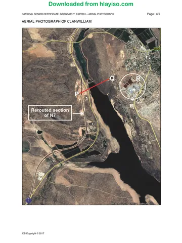
4.1 Study the aerial photograph of Clanwilliam (Colour Sheet) and refer to the
topographicmapextract 3218BB CLANWILLIAM.Read through the Fact File
on the ClanwilliamDam.
Fact File: Clanwilliam Dam
The Clanwilliam Dam is a concrete gravity dam built in 1935 on the Olifants River. To
provide a long-term reliable water supply the dam capacity must be increased by raising
the dam wall by 20 m. The safety of the dam must also be enhanced. To date, a water
treatment plant, workshop buildings and the potable* water works is complete. The N7
has also been rerouted. 66 properties will be affected and 45 have been expropriated*.
Photograph 6: Clanwilliam Dam
*Potable – drinkable water
*Expropriate – property that is
purchased by the government
[Source: Examiner's photograph]
4.1.1 Which is more recent, the aerial photograph or the topographic map
extract?
Aerial photograph
4.1.2 Provide ONE reason for your answer.
New N7 constructed/only old road on map.
Areas of urban development not on map.– area R and adjacent to
dam.
Date of the image (2016) and map was produced in 2010.
4.2 With reference to Photograph 6 and the topographic map extract
3218BBCLANWILLIAM, explain the shape of the Clanwilliam Dam.
Long, linear (narrow) because of mountain ranges.
Fold mountains give long, narrow valleys parallel to the mountains.
Along original river valley between mountain – must give shape and relief.
IEB Copyright © 2017 PLEASE TURN OVER
Downloaded from hlayiso.com
NATIONAL SENIOR CERTIFICATE: GEOGRAPHY: PAPER II – MARKING GUIDELINES Page 13 of 15
4.3 Study Figure 2 below, a cross section (labelled P to Q on the aerial
photograph) constructed using Google Earth. Refer also to the 1:50 000
topographic map extract 3218BB CLANWILLIAM.
Figure 2: A cross section (elevation profile) P to Q on aerial
photograph
New road must be above the new dam level.
4.3.1 (a) Using the textboxes, label the position P and Q on Figure 2
above.
(b) Fill in and indicate the approximate position of the new
rerouted section of the N7 on the cross section.
(c) (i) The dam wall will be raised by 20 m. This means the
capacity of the dam will therefore increase. Draw in a
horizontal line on Figure 2 to show the dam level once
the wall is by 20 m.
Note: Refer to the vertical interval provided on the cross
section.
The new level is approximately 0.7–1,0 cm above the
old level.
(ii) Explain what would happen to the areas surrounding
the dam, if the wall was raised by 20 m.
The surrounding areas would be flooded.
(iii) What GIS process would have been used by the
Department of Water Affairs to decide which properties
must be expropriated when the dam wall is raised?
Buffering
IEB Copyright © 2017 PLEASE TURN OVER
Downloaded from hlayiso.com
NATIONAL SENIOR CERTIFICATE: GEOGRAPHY: PAPER II – MARKING GUIDELINES Page 14 of 15
4.3.2 Land-use zones
Locate the area marked R on the aerial photograph. Refer also to the
1:50 000 topographic map extract 3218BB CLANWILLIAM.
Circle the correct underlined word in (a) below:
(a) The land-use zone (R) is industrial/residential/recreational.
(b) Explain how you arrived at your answer in Question 4.3.2 (a).
Symbol – longer/larger black blocks; outskirts of town; along a
road. If they just say buildings and no other ref – 1 mark
(c) Factoriesthe
Identify in this area/ roof
land-use surfaces
zone on the on map in– large
photograph
1:50 000 whichand
the
following functions are found. Provide also the block
flat
reference of where the function is located.
Feature Land-use zone Block reference
Sewerage works Rural-urban fringe
D6
Peri-urban fringe
Old Dutch Reform
Church and Police CBD D5
Station
4.4 Design an advertisement for a travel magazine to promote the Clanwilliam
Dam as a major tourist attraction in the region. Include in this
advertisement:
Location map and information (4)
Where to stay (2)
What to do at the Dam (2)
Tourist attractions in the area (include ONE attraction and provide map
evidence) (2)
Use page 16 for your advertisement.
IEB Copyright © 2017 PLEASE TURN OVER
Downloaded from hlayiso.com
NATIONAL SENIOR CERTIFICATE: GEOGRAPHY: PAPER II – MARKING GUIDELINES Page 15 of 15
Advertisement for a travel magazine to promote the Clanwilliam Dam.
Including location map
Allow 1 mark for just outline SA map; other information 3 marks; or if a proper map
given can award all for marks for the info contained.
GPS co-ordinates – 32 S and 18 E; N7 close to dam; south-west of Clanwilliam; on
Olifants River; foothills of Cederberg; Western Cape.
Where to stay
Crystal Waters Bokwater and Cedar Inn
Caleta Core
Caravan Park
Contact Clanwilliam Tourism/camping at Ramskop Nature Reserve Any 1
What to do at the dam
Jet ski – any water-related activity; birdwatching, hiking, game viewing; picnicking
Boating
Fishing
Skiing
Enjoy nature/cruises Any suitable recreational activity linked to the dam.
Tourist attractions must give map evidence. Any ONE attraction.
Walk in the Cedarberg – ref point Wine tasting B5; CL Leipoldt’s grave B11
Visit the museum/goal – D5
Visit Ramskop Nature Reserve D4
Visit Rooibos farms. D1
Golf nearby. E6
Accept any map-based point – must have some map link of reference.
Total: 100 marks
IEB Copyright © 2017
Study this subject
Revise the topics in this paper, then practise them question by question.
- Grade 12 Geography notes
CAPS revision notes with worked examples.
- Geography questions by topic
Past exam questions sorted by CAPS topic, with memos where available.
- Grade 12 Geography quizzes
Short topic quizzes with instant feedback.
- All Grade 12 Geography past papers
Past papers by year, with memos where available.
- Grade 12 IEB past papers
More Geography and other subjects in this collection.
Recommended for this subject
More papers and memos for this grade and subject.
MemorandumIEB
Geography Grade 12 IEB Paper 1 2019 Memo
MemorandumIEB
Geography Grade 12 IEB Paper 2 2019 Memo
MemorandumIEB
Geography Grade 12 IEB Paper 1 2018 Memo
MemorandumIEB
Geography Grade 12 IEB Paper 2 2018 Memo
MemorandumIEB
Geography Grade 12 IEB Paper 1 2018 Memo
MemorandumIEB
Geography Grade 12 IEB Paper 1 2017 Memo
Related documents
Question paperIEB
Geography Grade 12 IEB Paper 2 2017 Question Paper
Question paperIEB
Geography Grade 12 IEB Paper 2 2017 Question Paper
MemorandumIEB
Geography Grade 12 IEB Paper 1 2017 Memo
MemorandumIEB
Geography Grade 12 IEB Paper 2 2016 Memo
Question paperIEB
Geography Grade 12 IEB Paper 1 2017 Question Paper
AddendumIEB
Geography Grade 12 IEB Paper 1 2017 Addendum
More from Grade 12 Geography
Question paperIEB
Geography Grade 12 IEB Paper 1 2019 Question Paper
Question paperIEB
Geography Grade 12 IEB Paper 1 2019 Question Paper (Afrikaans)
Question paperIEB
Geography Grade 12 IEB Paper 1 2019 Question Paper (Afrikaans)
Question paperIEB
Geography Grade 12 IEB Paper 2 2019 Question Paper
Question paperIEB
Geography Grade 12 IEB Paper 2 2019 Question Paper (Afrikaans)
Question paperIEB