
Downloaded from hlayiso.com
NATIONAL SENIOR CERTIFICATE EXAMINATION
NOVEMBER 2018
GEOGRAPHY: PAPER I
MARKING GUIDELINES
Time: 3 hours 300 marks
These marking guidelines are prepared for use by examiners and sub-examiners,
all of whom are required to attend a standardisation meeting to ensure that the
guidelines are consistently interpreted and applied in the marking of candidates'
scripts.
The IEB will not enter into any discussions or correspondence about any marking
guidelines. It is acknowledged that there may be different views about some
matters of emphasis or detail in the guidelines. It is also recognised that,
without the benefit of attendance at a standardisation meeting, there may be
different interpretations of the application of the marking guidelines.
IEB Copyright © 2018 PLEASE TURN OVER
Skip to contentMemorandum 
View all
Geography Grade 12 IEB Paper 1 2018 Memo
IEB Grade 12 Geography Paper 1 memorandum from the 2018, 19 pages. Read online or get the free PDF download, question paper linked when available.
Publisher: IEB
Geography · Grade 12 · 2018. Memorandum, 19 pages. Read online or download the PDF.
- Subject
- Geography
- Grade
- Grade 12
- Document type
- Memorandum
- Year
- 2018
- Paper
- 1
- Publisher
- IEB
- Curriculum
- IEB
- Pages
- 19
- File size
- 595.7 KB
Loading document…
Loading document…
1 of 19
Document textSearch extracted text and jump to a page.
Downloaded from hlayiso.com
NATIONAL SENIOR CERTIFICATE: GEOGRAPHY: PAPER I – MARKING GUIDELINES Page 2 of 19
SECTION A GEOGRAPHICAL ISSUES
QUESTION 1 GEOGRAPHICAL CASE STUDY: THE GEOGRAPHY OF
THE ORANGE / SENQU RIVER BASIN AND THE
NORTHERN CAPE
1.1 Catchment and river management
(a) (i) The area from which rainfall flows into a river, lake, or reservoir.
Area drained by a river
(ii) The amount / volume of evaporation that would occur if a
sufficient water source were available.
(b) Candidates must show calculation to get full marks.
Height difference: 3 300 m – 0 m = 3 300 m
Distance: 2 300 km × 1 000 = 2 300 000 m
1: 696,97
(Any one)
(c) Constructed knickpoint
Gariep Dam
Vanderkloof Dam
Natural knickpoint Augrabies Falls
(d) A river is said to be rejuvenated when it is eroding the landscape in
response to a lowering / change of its base level. Evidence of
headward / downcutting / vertical erosion
(e) It cannot be graded as it has many knickpoints / temporary base
level of erosion (dams and waterfalls) along the river system,
therefore the profile is not smooth. multiconcave
(f)
River erodes through uplifted landscape. River not influenced by underlying strata
IEB Copyright © 2018 PLEASE TURN OVER
Downloaded from hlayiso.com
NATIONAL SENIOR CERTIFICATE: GEOGRAPHY: PAPER I – MARKING GUIDELINES Page 3 of 19
(g) This is due to the influence of the air circulation of the SAHP and
SIHP and the amount of moisture they push into the interior from the
dry west & humid east ocean currents which creates 500 mm
isohyet.
1.2 Settlement and fluvial processes
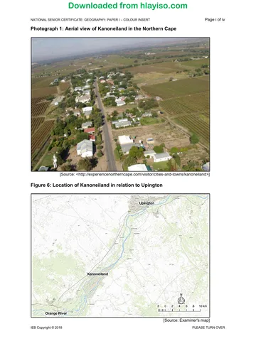
(a) Linear
ANY ONE OF THE FOLLOWING:
• The settlement built along the river
• The shape of the island
• The road running through the settlement
(b) ANY TWO OF THE FOLLOWING ANSWERS:
• Along the Orange River
• On fertile soil
• A lot of water
• Very dry climate
• Wet-point settlement
• Floodplain
• Flat land
• Alongside a road
(c) Wet-point
This is due to ...
• being next to the river in the dry region
• being built right next to the river
(d) ANY TWO REASONABLE ANSWERS
• It seems to have functions within the settlement, but not enough to
be a town. Low order functions / low number of functions
• The population seems higher than you would find in a hamlet, but
not enough to be a town. Town is not built-up enough
• Mostly uni-functional activity so cannot be regarded as urban.
(e) Braided.
(f) A braided channel is one that is divided into smaller channels by
temporary islands. Braided channels tend to form in rivers that have
a significant amount of sedimentary load, a steep profile and where
discharge regularly fluctuates.
OR
When the river's carrying capacity is exceeded, the river deposits its
load into the channel. This usually happens in a very dry region.
(g) The river has created very rich soil from the alluvium.
The braiding has made many fertile islands that can be used for farming.
NOT mining
IEB Copyright © 2018 PLEASE TURN OVER
Downloaded from hlayiso.com
NATIONAL SENIOR CERTIFICATE: GEOGRAPHY: PAPER I – MARKING GUIDELINES Page 4 of 19
1.3 Agriculture and valley climates
(a) Primary.
(b) Found in a valley and along the river.
The valley could have created a frost pocket.
The river creates moderating effect.
The aspect of the valley plays a role as grapes enjoy dry soil.
Flooding
Water supply (not related to climate)
Cool microclimate
Soil fertility
Thermal belt position
(c) ANY TWO RELEVANT ANSWERS
• Low workforce HIV / AIDS
• Low infrastructure
• Far from markets
• Soil erosion
• Fuel price
• Theft
• Land claims
• Pollution
• Insects
• Strong winds
• Frost pocket
• Flooding
(d) ANY THREE RELEVANT POINTS
• Creates more jobs
• Diversification of economy
• Creates better infrastructure
• Attracts other businesses
• Attracts investment
• Improves buying power
IEB Copyright © 2018 PLEASE TURN OVER
Downloaded from hlayiso.com
NATIONAL SENIOR CERTIFICATE: GEOGRAPHY: PAPER I – MARKING GUIDELINES Page 5 of 19
1.4 Khi Solar One post-apartheid economic development
(a) Energy that uses sources that can be used over and over again. Is
not finite
(b) ANY TWO RELEVANT POINTS
Northern Cape receives a high amount of solar energy due to low
rainfall and clear skies for more days than many other regions.
Available space.
(c) ANY THREE RELEVANT POINTS
Candidates are expected to EVALUATE and should therefore
expand on and explain each point.
• More jobs
• Better infrastructure
• Improved education
• More services provided
• More skilled jobs available
• More skills development in the region
• Attracts investment
• 1 item social
• 1 item economic
• 1 evaluation / opinion
1.5 Urban climates
Candidates
CRITERIA MARKS
Mark
Writing skills
• Taking into consideration structure and presentation.
5
• Use of brief introduction and conclusion.
• Logical discussion and use of subheadings.
Content knowledge
• Correct use of geographical terminology and concepts. 10
• Adherence to topic and subheadings.
Supporting evidence – analysis and understanding
• The ability to analyse and evaluate the topic is assessed in
this category.
• Reference made to case study material / fact file / source 5
material provided.
• If appropriate, reference must be made to familiar / local or
other examples.
Total for essay 20
IEB Copyright © 2018 PLEASE TURN OVER
Downloaded from hlayiso.com
NATIONAL SENIOR CERTIFICATE: GEOGRAPHY: PAPER I – MARKING GUIDELINES Page 6 of 19
(Level 3) (Level 2) (Level 1)
Criteria
Excellent – Good Satisfactory Poor
Writing skills
• Taking into Suitable introduction Introduction and Writing is weak and
consideration and conclusion. conclusion present, almost unintelligible. No
structure and Sophisticated, coherent although not ideal. introduction or
presentation. and structured writing. Attempts to adhere to conclusion provided. No
• Use of brief Subheadings and subheadings and use of use / adherence to
introduction and paragraphs have been paragraphs. subheadings. Long
conclusion. effectively used. Report deviates from sentences, poor
• Logical discussion Report is concise, well- the point in places and grammar and ineffective
and use of structured and succinct. lacks brevity. use of paragraphs.
subheadings. Report is repetitive.
Bullet points may have
been used.
1 = must be awarded for
any form of written
[5 marks allocated to attempt / effort
this component] (4–5 marks) (3 marks) (0–2 marks)
Content knowledge
• Correct use of Relevant content and Some relevant content. Digression from the
geographical detailed discussion of An overview / general topic.
terminology and topic. discussion of key Weak grasp of concepts
concepts. Good usage of issues. and terminology.
• Adherence to topic geographical Basic usage of Superficial / poor
and subheadings. terminology and geographical concepts discussion.
concepts. and terminology. Almost no relevant facts
Appropriate number of (60–50% of required / subheading.
facts presented / facts presented /
subheading. subheading).
Min of 2 points for every 1 point / sub-heading, or
sub-heading will earn 2 points provided and
candidate 10 marks. only 2 paragraphs.
Extension work will
provide a further
[10 marks be allocated 2 marks.
here] (8–10 marks) (5–7 marks) (0–4 marks)
Supporting evidence –
analysis and
understanding
• The ability to analyse The candidate is able to Superficial links made to Limited to no reference
and evaluate the argue and evaluate case study / made to case study /
topic is assessed in appropriately. Fact File / source Fact File / source
this category. There is strong material. material.
• Reference made to evidence of accurate Although reference to Examples not provided.
case study material / application of supporting examples Has little to no
Fact File / source understanding and has been made, it is not geographical meaning.
material provided. evidence provided. clear that the candidate Little analysis or
• If appropriate, Report demonstrates has a good understanding.
reference must be understanding and understanding of the Demonstrates minimal
made to familiar / integration of relevant example / case study understanding of topic.
local or other case study / Fact File / material.
examples. source material into the Supporting evidence
context of the report. does not always relate
Looking for evidence of appropriately to the
unpacking content and subheading or context
high-order integration. of discussion.
Discussion lacks depth.
[5 marks allocated to (4–5 marks) (3 marks) (0–2 marks)
this component]
IEB Copyright © 2018 PLEASE TURN OVER
Downloaded from hlayiso.com
NATIONAL SENIOR CERTIFICATE: GEOGRAPHY: PAPER I – MARKING GUIDELINES Page 7 of 19
In your report you must cover the following aspects:
• Outline the observed temperature variation (rural vs urban)
‒ Rural areas are cooler than urban
‒ Kanoneiland is cooler than Upington,
particularly during the winter months
Upington approximately 2°C higher than Kanoneiland throughout the year
Greatest difference in early mornings in Spring. Smallest difference in Summer
daytime temps.
• Describe possible causes of heat in an urban area
‒ Albedo effect. Dark colours absorb heat, light colours reflect
‒ More surface heat retention
‒ More artificial heat – aircons, cars, factories
‒ More tar, darker building material
‒ More pollution to trap the heat
‒ Population numbers – accepting body heat (some textbooks mention this)
• Evaluate how the UHI has exacerbated* the temperatures felt in
Upington
‒ Upington is in a warm / arid region, this will make it even warmer
‒ More wind will move more dust around due to the arid region
‒ More dust would make dust dome thicker and absorb more heat energy,
making it warmer.
‒ More pollution would add to the trapped heat in the settlement
‒ Impacts on human health and performance
• Explore solutions urban areas such as Upington could implement
‒ Rooftop gardens
‒ Paint using different colours – rather mention lighter colours
‒ Build with more reflective material
‒ Public Transport, less pollution, lift clubs, walking and cycling
‒ More green areas within the urban space
‒ More open water
‒ Building design and / or orientation – prevailing wind. Aerodynamic
building shapes
‒ Renewable energies, e.g. solar power
‒ Filters on chimneys
‒ Fine companies that pollute
• Please DO NOT tick when marking an essay – this confuses the checkers.
• Rather, underline valid and appropriate points and use the code system below.
GEOGRAPHY ESSAY CONTENT
CODES
_____________ Underline relevant points if correct
E – Excellent
G – Good Circle incorrect points
V – Vague
R – Repetition EVIDENCE
I – Irrelevant
F – Fair Place in () brackets where candidates have used evidence
IEB Copyright © 2018 PLEASE TURN OVER
Downloaded from hlayiso.com
NATIONAL SENIOR CERTIFICATE: GEOGRAPHY: PAPER I – MARKING GUIDELINES Page 8 of 19
SECTION B CLIMATE, WEATHER AND GEOMORPHOLOGY
QUESTION 2 MID-LATITUDE CYCLONE, TROPICAL CYCLONE, LOCAL
WEATHER, RIVER BASIN STUDY, RIVER CHANNEL AND
FEATURES, DROUGHT
2.1 Mid-latitude cyclone
(a) D Isotherms
(b) A Cold sector
(c) A Kalahari / interior anticyclone
(d) A Backing
(e) C Rainy with a strong south-
D Thunderstorms, gale force winds
2.2 Tropical cyclones
(a) Eye of the storm / centre or middle of storm / eye wall
(b) ANY TWO RELEVANT POINTS
• Warm ocean with a temperature greater than 26 or 27 degrees
Coriolis effect
• Low wind shear / light and variable winds
• Deep low-pressure / low pressure cell
• High humidity
• High evaporation rate
• Area of development between 5 and 25 degrees S / tropical
regions
• Latent heat
• Undisturbed period of several days
(c) Inhambane 80 to 100 km / h
Vilanculos 60 to 80 km / h
(d) Inhambane will experience most strong winds and worst effects. This
is due to it being the dangerous semi-circle where the winds are
moving in the same direction as the storm, which makes them
stronger.
First or leading quadrant storm is compressed leading to steeper
pressure gradient and stronger winds.
Inhambane has onshore winds resulting in the storm surge and more
damage.
Not acceptable to say that Inhambane is closer to the eye.
IEB Copyright © 2018 PLEASE TURN OVER
Downloaded from hlayiso.com
NATIONAL SENIOR CERTIFICATE: GEOGRAPHY: PAPER I – MARKING GUIDELINES Page 9 of 19
(e) ANY TWO / Three RELEVANT POINTS
Candidates are expected to EVALUATE and should therefore
expand on and explain each point.
• Mozambique is an LEDC
• Poorly built houses
• Poor infrastructure
• No warning system
• Poor evacuation procedures
• Lack stocks of food and water
• Lack of insurance
• Monoculture / subsistence farmers therefore more
affected
• Lack of medical care / water borne diseases
• Impact on the economy
2.3 Local weather
(a) ANY ONE RELEVANT POINT
• Low-pressure trough / low pressure / trough / interior low /
thermal low
• Moisture front
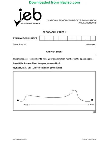
(b)
Cooler, drier air from the SAHP Moist warm air from SIHP and
and Atlantic Ocean Indian Ocean
for convergence of winds for Cb cloud
position of moisture front
formation of hail
IEB Copyright © 2018 PLEASE TURN OVER
Downloaded from hlayiso.com
NATIONAL SENIOR CERTIFICATE: GEOGRAPHY: PAPER I – MARKING GUIDELINES Page 10 of 19
(c) Weather station symbol must have the following elements
The stations can have any three of the following.
• Rainfall
• Strong winds 25 – 50 knots
• Overcast 6 / 8 to 8 / 8
• Wind directions from South East to South West
• Temperatures: Above 18 and range less than 5
(d) ANY TWO RELEVANT POINTS
• Blocked drains create more impermeable surfaces
• Fewer infiltrations, therefore more runoff
• More river channelisation
2.4 Drainage systems in South Africa
(a) (i) Drakensberg
(ii) Deposition
(iii) Interfluve
(iv) Dendritic
(b) (i) Hydrograph A
(ii) ANY TWO RELEVANT ANSWERS
• This is a summer rainfall region
• This would be a permanent river due to the regions it is
found in
• The river is being fed by the Vaal / Tugela and Lesotho
Highlands Water Projects
If hydorgraph C is chosen in (i) then this is a summer rainfall
region is marked correct
If hydorgraph B is chosen in (i) then this is a permanent river
is marked correct
IEB Copyright © 2018 PLEASE TURN OVER
Downloaded from hlayiso.com
NATIONAL SENIOR CERTIFICATE: GEOGRAPHY: PAPER I – MARKING GUIDELINES Page 11 of 19
(iii) ANY TWO RELEVANT ANSWERS
• Increases the flood peak
• Shortens the lag time
• Makes the rising limb steeper
If stated that urban areas increased water off-take
then reduced discharge was accepted.
(iv) ANY THREE RELEVANT ANSWERS
Candidates are expected to ELABORATE and should
therefore expand on and explain each point.
• Gauteng is not built on a major water source
• South Africa has a very variable rainfall
• Water for very large populations / demand is increasing
Major industries in the Gauteng region need water
• Need for irrigation
• Used to generate HEP
• Low rainfall
2.5 River channel, fluvial process and fluvial features
(a) Upper / Youthful
(b) Turbulent
(c) Rapid or Steep sided Valley / V shaped Valley
(d) Rapids are areas of shallow, fast-flowing water in a stream. Rapids
tend to form in younger streams, with water flow that is straighter and
faster than in older streams. Softer rocks in the streambed erode, or
wear away, faster than harder rocks. This process is known as
differential erosion.
Or
Downward erosion caused by the turbulent flow of the river.
(e) Traction or saltation
(f) This occurs when the river is in flood.
The channel then has enough energy to carry the boulders along the
river bed.
Steep gradient / fast moving
2.6 Dams and drought
(a) Water security can be defined as the ability to access sufficient quantities
of clean water to maintain adequate standards of food and goods
production, proper sanitation, and sustainable health care.
(b) 56,4 – 36,2 = 20,2
20,2 / 56,4 × 100 = 35,82% (from 35–36%)
IEB Copyright © 2018 PLEASE TURN OVER
Downloaded from hlayiso.com
NATIONAL SENIOR CERTIFICATE: GEOGRAPHY: PAPER I – MARKING GUIDELINES Page 12 of 19
(c) Two marks are given for the design of the Infographic / 1 mark for design
structure and 1 mark for differentiating between consequences and
solutions
"An infographic (information graphic) is a representation of information in a
graphic format designed to make the data easily understandable at a
glance."
ANY TWO RELEVANT POINTS under one and one point under the
other
• Consequences
‒ Industry cannot operate normally – job losses
‒ Agriculture cannot irrigate – job losses, food insecurity
‒ Water becomes more expensive to the people
‒ Loss of tourism
‒ Water restrictions (if used as a consequence cannot be used as a
solution)
• Solutions
‒ Desalinisation
‒ Boreholes
‒ Fines for overuse
‒ More dams
‒ Covered reservoirs / pools
‒ Rain water harvesting
‒ Storage tanks
‒ Water restrictions
‒ Grey water usage
‒ Inter-basin transfers
IEB Copyright © 2018 PLEASE TURN OVER
Downloaded from hlayiso.com
NATIONAL SENIOR CERTIFICATE: GEOGRAPHY: PAPER I – MARKING GUIDELINES Page 13 of 19
SECTION C RURAL AND URBAN SETTLEMENT AND ECONOMIC
GEOGRAPHY OF SOUTH AFRICA
QUESTION 3 RURAL SETTLEMENT, URBANISATION, INFORMAL
SETTLEMENTS, URBAN FUNCTIONS, MIXED-USE
DEVELOPMENT AND URBAN RENEWAL, LAND REFORM,
ECONOMIC SECTORS, GAUTENG, DIAMOND MINING
3.1 Rural settlement
(a) (i) Pattern – Dispersed accepted all as photograph not clear
(ii) Shape – Round
(iii) Type – Farmstead
(iv) Type of farming activity– Subsistence
(b) ANY THREE RELEVANT POINTS
Candidates are expected to ASSESS and should therefore expand
on and explain each point.
• As rural areas develop they change their functions
• The development of infrastructure
• Development of homes
• Counter-urbanism causes rural areas to develop more
• Functions that should be found in urban areas are found in rural
areas
• Just Differentiation between rural and urban areas – max 4
• NO – as distinction is clear as more rural depopulation occurring
resulting in decline in services in rural area
• Linking comparison to differences in MEDC and LEDC
3.2 Urbanisation
(a) 504 people per day
21 × 24 = 504
(b) ANY TWO RELEVANT ANSWERS
• Discuss push or pull factors (push e.g. drought; conflict;
mechanization)
• More jobs in urban areas
• Bright light syndrome
• Lack of rural jobs
• Perceived better jobs in urban areas
• Better services in urban areas
• Rural-urban migration
• Better quality of life / improved standard of living
• Migrant labour / join families
• Better access to education
• Health care opportunities
• Perceived idea of increased housing opportunities in urban
• Improved Infrastructure
IEB Copyright © 2018 PLEASE TURN OVER
Downloaded from hlayiso.com
NATIONAL SENIOR CERTIFICATE: GEOGRAPHY: PAPER I – MARKING GUIDELINES Page 14 of 19
(c) Candidates are expected to ASSESS the benefits and should
therefore expand on and explain each point.
• More education opportunities
• Possibility of jobs
• Possibility of better housing
• Possibility of better services
• Possibility of better infrastructure
• Possibility of better shops
• Possibility of better healthcare
• Safer in urban (better security, away from farm murderers)
• Entertainment opportunities
• Jobs (1 mark) – no explanation
• Housing (1 mark) – no explanation
3.3 Informal settlement
(a) ANY ONE RELEVANT PIECE OF EVIDENCE
• Houses are made of makeshift material.
• No proper infrastructure visible.
• Shacks
(b) ANY ONE
• Electricity
• Power cables
• Road
• Telephone lines
• Street lights
(c) ANY TWO RELEVANT ANSWERS
Candidates are expected to EXPLORE and should therefore expand
on and explain each point.
• Fires
• Cold
• Flash Floods
• Crime
• Unemployment
• Heat
• Lack of services( poor sanitation, spreading of diseases)
• No fixed address (cannot open accounts, etc.)
• Cost of transport
• Privacy issues / overcrowding
IEB Copyright © 2018 PLEASE TURN OVER
Downloaded from hlayiso.com
NATIONAL SENIOR CERTIFICATE: GEOGRAPHY: PAPER I – MARKING GUIDELINES Page 15 of 19
3.4 Urban functions
(a) B / meat world
(b) Any option with justification
Adam's Bait Shop / C
ANY ONE RELEVANT ANSWER
• Fishing is very specialised.
• Fewer people would use the store but they would travel further to
do so.
B – can justify that they would travel far to the specialised
halaal butcher
A – car wash with justification (specialized service, will travel
far to get)
(c) Functional convenience
ANY ONE REASONABLE ANSWER
• The businesses are on the corner of the road
• The businesses are unrelated and won't help each other and are
not in competition
• Accessible / Convenient as on the corner
3.5 Mixed-use development and urban renewal
(a) (i) Mixed-use development is a type of urban development that
blends residential, commercial, cultural, institutional, or
entertainment uses, where these functions are physically and
functionally integrated and provide pedestrian connections.
Eat / sleep / play area
Integrated area
More than 1 use
(ii) The area within the walls or perceived boundaries of a
particular building or place.
OR
An area in a town designated for specific or restricted use,
especially one that is closed to traffic.
Area designed or reserved for a specific use
(b) ANY THREE RELEVANT ANSWERS
Must be ONE social and ONE economic consequence and
any other; can be positive or negative
• The property value will rise
• More congestion (people and vehicles)
• New businesses will be established
• More high-end jobs available
• People displaced
• People cannot afford to live in the area
• Increased trade
• More crime
• Overburdened infrastructure
• More tax for the municipality
• Entertainment opportunities
• More business resulting in more competition
IEB Copyright © 2018 PLEASE TURN OVER
Downloaded from hlayiso.com
NATIONAL SENIOR CERTIFICATE: GEOGRAPHY: PAPER I – MARKING GUIDELINES Page 16 of 19
3.6 Land reform
Land issues
• Farmers untrained
• Under-capitalisation
• Corruption
• Government funds not used appropriately
• Slow process / backlog
• Farmers not working on the land / neglected
• Land expropriation without compensation
• Lack of training and support
Land tenure
• Land tenure is the legal regime in which land is owned by an individual
• Willing seller, willing buyer
• Who owns the land legally
• Legal right to ownership
Land redistribution Land restitution
Giving the land back to the original Solution for people who had lost
owners of the land. their land as a result of racially
Providing an opportunity for new discriminatory practices such as
emerging farmers. forced removals.
Government owned land been This included people who were
given back / to new owners dumped in Bantustans and put
under traditional leaders.
Getting own land back or
compensated
Distribute and restore concept
3.7 Structure of the economy and informal sector
(a) Quaternary / tertiary
(b) ANY TWO RELEVANT POINTS
• Soweto has a much bigger population than Sandton, but Soweto
has poor infrastructure and hence low fixed-line internet access.
• Soweto has a high demand for internet access and because cell
phones are readily available, internet access through cell phones
is high, despite cell phone data being more expensive.
• Sandton is an exceptionally wealthy financial and commercial
centre with excellent infrastructure and massive investment and
development and consequentially very high internet access,
especially via fixed lines.
• More businesses in Sandton therefore more fixed line compared
to data.
IEB Copyright © 2018 PLEASE TURN OVER
Downloaded from hlayiso.com
NATIONAL SENIOR CERTIFICATE: GEOGRAPHY: PAPER I – MARKING GUIDELINES Page 17 of 19
(c) (i) An economy that is neither taxed nor monitored by any form of
government. Unlike the formal economy, activities of the informal
economy are included in neither the gross national product
(GNP) nor the gross domestic product (GDP) of a country.
(ii) ANY REASONABLE ANSWER
This is a DISCUSS question so the candidate cannot just list.
• Very easy to sell on the side of the road
• Cheap product
• Moves very quickly
• In many cases untraceable
• Demand for data is increasing
• Convenient
• No overheads
• Easy movable product
• Do not need high level of skills (low level of education)
• No processing needed in order to sell
IEB Copyright © 2018 PLEASE TURN OVER
Downloaded from hlayiso.com
NATIONAL SENIOR CERTIFICATE: GEOGRAPHY: PAPER I – MARKING GUIDELINES Page 18 of 19
3.8 Gauteng
Mindmap – ONE point under each heading and any TWO others
Factors that
Major promote
Industries Industrial
development
• Financial and business • Political stability
services • Consistent economic policies,
• Retail and wholesale trade creating an investor-friendly climate
• Community and social with attractive incentives
services • Excellent infrastructure and transport
• Automotive (BMW and Nissan) network (e.g. Maputo Corridor)
• Mining links • A large labour pool
• Chemicals • South African electricity prices are
• Logistics amongst the lowest in the world
• ICT and pharmaceutical • Inexpensive land and low building
• Denel aviation costs
• AECI / Sasol • Raw materials (discovery of gold)
• Unilever • Infrastructure to deliver water
• Nampak • Flat land
• Consol • Communication networks
Gauteng
Factors that Aspects
contributing
hinder
to future
industrial economic
development growth
• Large unskilled labour force • SDI (spatial development initiative)
• Aging infrastructure • Accessibility
• Water shortages • Quick growth
• Power shortages – load • New markets
shedding • Reverse spatial injustice (improve
• Strikes / labour disputes neglected areas)
• Pollution (air, water, land) • Provincial government supporting
• Resource depletion growth and development
• Overpopulation (depletion of • New economic nodes
services) • Upgraded infrastructure
• Lack of suitable land • New cities
• Competition / oversaturated • Multiplier effect
market • Political stability
• Crime
• Corruption
• HIV/AIDS – lowers productivity
• Industrial decentralisation
IEB Copyright © 2018 PLEASE TURN OVER
Downloaded from hlayiso.com
NATIONAL SENIOR CERTIFICATE: GEOGRAPHY: PAPER I – MARKING GUIDELINES Page 19 of 19
3.9 Diamond mining
(a) (i) Maximum production
Full capacity
(ii) An (igneous) rock, which sometimes contains diamonds.
(b) Botswana
(c) • The world economy stabilised (many countries moved forward with
the end of the Cold War).
• More people had access to money and bought diamonds.
• Increased demand
• Improved mining techniques
• New reserves found
(d) • The world economy in a better shape.
• Moving out of the recession of 2008.
• Supply and demand in balance (influence of De Beers?)
• Stable but not increasing
Total: 300 marks
IEB Copyright © 2018
Study this subject
Revise the topics in this paper, then practise them question by question.
- Grade 12 Geography notes
CAPS revision notes with worked examples.
- Geography questions by topic
Past exam questions sorted by CAPS topic, with memos where available.
- Grade 12 Geography quizzes
Short topic quizzes with instant feedback.
- All Grade 12 Geography past papers
Past papers by year, with memos where available.
- Grade 12 IEB past papers
More Geography and other subjects in this collection.
Recommended for this subject
More papers and memos for this grade and subject.
MemorandumIEB
Geography Grade 12 IEB Paper 1 2019 Memo
MemorandumIEB
Geography Grade 12 IEB Paper 2 2019 Memo
MemorandumIEB
Geography Grade 12 IEB Paper 2 2018 Memo
MemorandumIEB
Geography Grade 12 IEB Paper 1 2018 Memo
MemorandumIEB
Geography Grade 12 IEB Paper 1 2017 Memo
MemorandumIEB
Geography Grade 12 IEB Paper 2 2017 Memo
Related documents
Question paperIEB
Geography Grade 12 IEB Paper 1 2018 Question Paper
AddendumIEB
Geography Grade 12 IEB Paper 1 2018 Addendum
MemorandumIEB
Geography Grade 12 IEB Paper 1 2017 Memo
MemorandumIEB
Geography Grade 12 IEB Paper 1 2016 Memo
Question paperIEB
Geography Grade 12 IEB Paper 2 2018 Question Paper
Question paperIEB
Geography Grade 12 IEB Paper 2 2018 Question Paper
More from Grade 12 Geography
Question paperIEB
Geography Grade 12 IEB Paper 1 2019 Question Paper
Question paperIEB
Geography Grade 12 IEB Paper 1 2019 Question Paper (Afrikaans)
Question paperIEB
Geography Grade 12 IEB Paper 1 2019 Question Paper (Afrikaans)
Question paperIEB
Geography Grade 12 IEB Paper 2 2019 Question Paper
Question paperIEB
Geography Grade 12 IEB Paper 2 2019 Question Paper (Afrikaans)
Question paperIEB