
Mock
hlayiso mock exams
Practice Series:
Grade 11 Exam Preparation
WWW.HLAYISO.COM
NATIONAL
SENIOR CERTIFICATE
GRADE 11
GEOGRAPHY P2
NOVEMBER EXAMINATION 2026 (MOCK)
MARKING GUIDELINES
MARKS: 150
These marking guidelines consist of 9 pages.
Copyright reserved Please turn over
Skip to contentAll 2026 papers 
View all


Geography Grade 11 P2 November Mock Exam 2 2026 Memo (Eng)
Grade 11 Geography Paper 2 memorandum from the November Mock Exam 2 2026 (English), 9 pages. Read online or download the free PDF.
Geography · Grade 11 · November Mock Exam 2 · 2026 · English. Memorandum, 9 pages. Read online or download the PDF.
- Subject
- Geography
- Grade
- Grade 11
- Language
- English
- Document type
- Memorandum
- Year
- 2026
- Exam period
- November Mock Exam 2
- Paper
- 2
- Publisher
- Hlayiso
- Curriculum
- CAPS
- Pages
- 9
- File size
- 147.3 KB
Free to read online, no sign-up needed
Loading document…
Loading document…
1 of 9
This exam
November Mock Exam 2 2026
- Paper 1Question paperAddendumMemo
- Paper 2Question paperAddendumMemo
Document textSearch extracted text and jump to a page.
Geography/P2 2 Hlayiso/Mock 2026
NSC – Marking Guidelines
NOTE TO MARKERS:
• Accept alternative answers that are correct and relevant to the question, even if not
listed.
• A mark is allocated for each correct fact. For (2 x 2) questions, award 2 marks per
complete, well-explained point.
• Paragraph questions (approximately EIGHT lines): assess the quality and relevance of
the response.
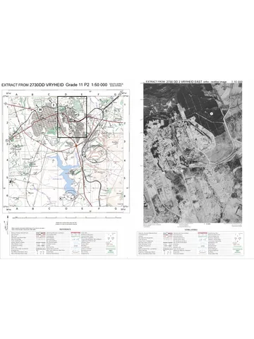
• Section B: the map distances used in calculations are GIVEN in the questions (the A3
map sheet is reduced). Follow the steps indicated; apply consistent accuracy (CA) where
an earlier step is wrong.
SECTION A
QUESTION 1: DEVELOPMENT GEOGRAPHY
1.1 1.1.1 more (1) (8 x 1) (8)
1.1.2 Gross National Income per capita (1)
1.1.3 high (1)
1.1.4 newly industrialised (1)
1.1.5 core (1)
1.1.6 bilateral (1)
1.1.7 trade deficit (1)
1.1.8 Fair (1)
1.2 1.2.1 A (1) (7 x 1) (7)
1.2.2 B (1)
1.2.3 A (1)
1.2.4 A (1)
1.2.5 B (1)
1.2.6 D (1)
1.2.7 B (1)
1.3.1 The process by which countries, economies and people of the (1 x 2) (2)
world become increasingly connected and interdependent through
trade, investment, technology, communication and culture (2)
1.3.2 More than 40 (countries) (1) (1 x 1) (1)
1.3.3 About 4 000 people are employed at the factory (1) (2 x 1) (2)
Thousands more people work for local suppliers (1)
Local suppliers (seats and tyres) get orders/business (1)
Vehicles are exported (earning foreign income) (1)
[ANY TWO]
Copyright reserved Please turn over
Geography/P2 3 Hlayiso/Mock 2026
NSC – Marking Guidelines
1.3.4 Important decisions are taken at the head office overseas, not in (2 x 2) (4)
South Africa (2)
Changes in demand in other countries (e.g. Europe) lead to job
losses and lost orders locally (2)
MNCs can move their factories to cheaper countries, leaving
unemployment (2)
Profits are sent back to the home country instead of being
reinvested locally (2)
Local firms depend on the MNC for orders/cannot compete with
MNCs (2)
[ANY TWO]
1.3.5 Become suppliers of parts/services to multinational companies (2) (3 x 2) (6)
Sell products online to customers in other countries (e-commerce)
(2)
Use modern technology and the internet to advertise and reach
larger markets (2)
Form partnerships/joint ventures with foreign companies (2)
Make use of export incentives and trade agreements (e.g. SADC,
AfCFTA) to export (2)
Improve product quality to meet international standards (2)
Specialise in unique local products (crafts, tourism) that are in
demand overseas (2)
[ANY THREE]
1.4.1 Emergency assistance (food, shelter, water, medical care) given to (1 x 2) (2)
save lives and reduce suffering during or after a disaster or crisis (2)
1.4.2 United Nations agencies (1) (1 x 1) (1)
Non-governmental organisations (NGOs) (1)
Neighbouring (SADC) countries/governments (1)
[ANY ONE]
1.4.3 Food parcels (1) (2 x 1) (2)
Tents (1)
Water-purification tablets (1)
Medical teams (1)
[ANY TWO]
1.4.4 It only meets immediate (urgent) needs during and shortly after the (1 x 2) (2)
disaster and does not deal with the long-term causes of
poverty/rebuilding (2)
Aid workers leave after a few months, so communities are not able
to rebuild (2)
[ANY ONE]
Copyright reserved Please turn over
Geography/P2 4 Hlayiso/Mock 2026
NSC – Marking Guidelines
1.4.5 Funds can be used to build stronger houses, roads and bridges that (4 x 2) (8)
can withstand cyclones and floods (2); technical experts can train
local engineers/builders in disaster-resistant building methods (2);
early-warning systems and weather forecasting can be set up and
staff trained to use them (2); communities can be trained in disaster
preparedness and evacuation (2); aid can pay for relocating
settlements away from flood-prone coastal areas (2); drainage
systems/flood barriers and mangrove/vegetation restoration reduce
flooding (2); strengthening health and emergency services so that
they respond faster (2); job creation and poverty reduction make
households less vulnerable and able to recover (2); reduces
dependence on emergency aid in the future (2)
[ANY FOUR]
1.5.1 Development that is planned, owned and carried out by the (1 x 2) (2)
members of a community, using local resources and skills to
improve their own quality of life (bottom-up development) (2)
1.5.2 The municipality (1) (1 x 1) (1)
1.5.3 Removes plastic and glass from streams/grazing land (1) (2 x 1) (2)
Streams are cleaner (1)
Waste is recycled into paving bricks (less waste) (1)
Safer grazing land for livestock (1)
[ANY TWO]
1.5.4 The municipality provided land for the sorting yard, so the project (2 x 2) (4)
did not have to buy or rent land (2)
The NGO trained members to sort waste, keep records and make
bricks, giving them the skills to run the project (2)
NGO funding paid for start-up costs (e.g. equipment/truck) that the
community could not afford (2)
Partnerships gave the community access to expertise and
resources it did not have (2)
Support from the municipality gives the project recognition and
possible customers/contracts (e.g. for paving bricks) (2)
[ANY TWO]
1.5.5 Charge a fee for collecting waste from households and businesses (3 x 2) (6)
(2)
Sell more products (paving bricks) to the municipality, schools and
builders (2)
Apply for government/municipal grants or partner with private
companies (social responsibility funding) (2)
Save part of the income for maintenance and to repair/replace the
truck (2)
Train more members so that skills stay in the community (2)
Register as a co-operative to access loans and contracts (2)
Find long-term contracts with recycling companies to get stable
prices (2)
[ANY THREE]
[60]
Copyright reserved Please turn over
Geography/P2 5 Hlayiso/Mock 2026
NSC – Marking Guidelines
QUESTION 2: RESOURCES AND SUSTAINABILITY
2.1 2.1.1 Y (1) (8 x 1) (8)
2.1.2 Z (1)
2.1.3 Y (1)
2.1.4 Z (1)
2.1.5 Z (1)
2.1.6 Y (1)
2.1.7 Z (1)
2.1.8 Y (1)
2.2 2.2.1 B (1) (7 x 1) (7)
2.2.2 D (1)
2.2.3 C (1)
2.2.4 B (1)
2.2.5 C (1)
2.2.6 D (1)
2.2.7 A (1)
2.3.1 Plot 3 (maize ploughed up and down the slope) (1) (1 x 1) (1)
2.3.2 25 ÷ 3 (1) (2 x 1) (2)
= 8,3 times (accept 8 times) (1)
2.3.3 Ploughing along the contours forms ridges that slow down runoff (1 x 2) (2)
and allow water to infiltrate (2)
The crop residue covers the soil, protecting it from raindrop impact
and slowing down runoff (2)
[ANY ONE]
2.3.4 Loss of fertile topsoil/nutrients (1) (2 x 1) (2)
Lower crop yields (1)
Lower income/profits (1)
More money spent on fertilisers (1)
Land becomes unusable (gullies) (1)
[ANY TWO]
2.3.5 Reduce the number of livestock to the carrying capacity of the land (4 x 2) (8)
(2); practise rotational grazing/divide the land into camps so that
grass can recover (2); fence off badly eroded areas and allow them
to rest (2); replant grass and indigenous trees (re-vegetation) to
bind the soil (2); build gabions/stone packs and small dams across
gullies to slow down runoff and trap soil (2); fill in and stabilise
dongas (2); control veld fires/avoid burning (2); educate the
community on sustainable land management (2); form a community
grazing committee to manage the land (2); get support from the
Department of Agriculture/land-care programmes (2)
[ANY FOUR]
2.4.1 A shortage of energy supply that cannot meet the demand, leading (1 x 2) (2)
to load shedding/high energy prices (2)
2.4.2 Frequent breakdowns at ageing (old) coal-fired power stations (1) (1 x 1) (1)
Copyright reserved Please turn over
Geography/P2 6 Hlayiso/Mock 2026
NSC – Marking Guidelines
2.4.3 Lost production (1) (2 x 1) (2)
Food went off (spoiled) in fridges (1)
Had to buy diesel generators (1)
[ANY TWO]
2.4.4 South Africa has large, easily mined coal reserves (2) (2 x 2) (4)
Coal is cheap to mine, so electricity is relatively cheap (2)
Existing power stations and the grid were built around coal (2)
Coal provides a reliable supply (day and night/base load) (2)
Coal mining and power stations employ many people (2)
Renewable energy and nuclear are expensive to build and take
time (2)
[ANY TWO]
2.4.5 Loss of jobs in coal mines and power stations (2) (3 x 2) (6)
Increased unemployment and poverty (2)
Local businesses (shops, transport) lose customers and close (2)
Municipalities lose income/rates and services decline (2)
Workers’ skills may not suit new industries; retraining is needed (2)
People migrate away to find work, breaking up
families/communities (2)
Increase in social problems such as crime (2)
Property values drop (2)
[ANY THREE]
2.5.1 Energy from sources that are naturally replaced and will not run out, (1 x 2) (2)
e.g. sun, wind and water (2)
2.5.2 To have electricity during power cuts/load shedding (1) (1 x 1) (1)
To lower monthly electricity bills (1)
[ANY ONE]
2.5.3 Expensive (a complete system can cost more than R100 000) (1) (2 x 1) (2)
Little electricity on cloudy days (1)
No electricity at night (1)
Old batteries contain chemicals that must be disposed of safely (1)
[ANY TWO]
2.5.4 National grid: less demand on the national grid, which reduces (2 x 2) (4)
load shedding (2); extra electricity fed back into the grid adds to the
supply (2)
Environment: less coal is burned, so fewer greenhouse
gases/carbon dioxide are released (less global warming) (2); less
air pollution/acid rain (2); less water is used by power stations (2)
[ANY TWO]
Copyright reserved Please turn over
Geography/P2 7 Hlayiso/Mock 2026
NSC – Marking Guidelines
2.5.5 Give subsidies/grants or tax rebates for solar systems (2) (3 x 2) (6)
Remove/reduce import duties and VAT on solar panels and
batteries (2)
Offer low-interest loans or pay-as-you-go schemes (2)
Install solar panels/solar water heaters on RDP and low-cost
houses (2)
Support local manufacturing of solar panels to reduce prices (2)
Create community solar projects/mini-grids that share costs (2)
Allow households to sell extra electricity to the grid at a fair price (2)
[ANY THREE]
[60]
TOTAL SECTION A: 120
Copyright reserved Please turn over
Geography/P2 8 Hlayiso/Mock 2026
NSC – Marking Guidelines
SECTION B
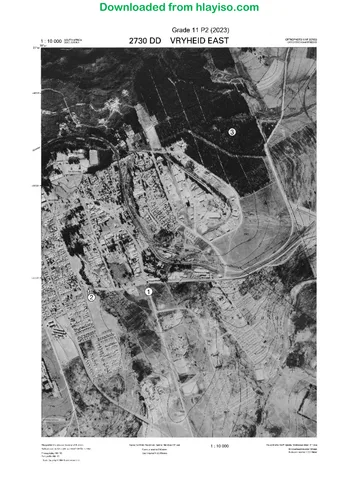
QUESTION 3: GEOGRAPHICAL SKILLS AND TECHNIQUES
3.1.1 A (1) (1 x 1) (1)
3.1.2 C (1) (1 x 1) (1)
3.1.3 VI = 1 430,9 − 1 209 = 221,9 m (1) (4 x 1) (4)
HE = 3,0 cm × 500 = 1 500 m (1)
221,9
Gradient = (1) (correct substitution)
1 500
= 1 : 6,8 (1) (accept 1 in 6,8; accept 1 : 6,7 – 1 : 6,8; CA)
3.1.4 Difference in years: 2026 − 2001 = 25 years (1) (3 x 1) (3)
Total change: 25 × 4′ = 100′ = 1◦ 40′ west (1)
Magnetic declination 2026: 23◦ 46′ + 1◦ 40′ = 25◦ 26′ west of true north
(1) (CA)
3.1.5 Length: 8,3 × 0,5 = 4,15 km (1) (3 x 1) (3)
Breadth: 5,8 × 0,5 = 2,9 km (1)
Area = 4,15 × 2,9 = 12,04 km2 (accept 12 km2 ) (1) (CA)
3.2.1 B (1) (1 x 1) (1)
3.2.2 Large open area with few buildings/settlements (1) (2 x 1) (2)
Gentle slope/flat land (contours far apart) (1)
Close to the power line (T) to connect to the grid (1)
Close to a road for access/transport of equipment (1)
Land is not cultivated/not used for crops (1)
High-lying/flat plateau land (trig stations 381 at 1 214,1 m and 84 at
1 217,0 m) (1)
Few trees/woodland to shade panels (1)
[ANY TWO]
3.2.3 Gully (donga) erosion (1) (1 x 1) (1)
3.2.4 The slopes of eNtendekwana are steep (contours close together), (1 x 2) (2)
so rainwater runs off quickly with more energy, less water infiltrates
and more soil is washed away (2)
3.2.5 Contour ploughing/strip cropping (along the contours) (1) (1 x 1) (1)
3.2.6 Loss of fertile topsoil lowers crop/grazing yields (2) (1 x 2) (2)
Gullies make land unusable and cut off access for
machinery/livestock (2)
Sediment fills nearby farm dams/reservoirs (2)
Livestock can be injured in dongas (2)
[ANY ONE]
3.2.7 The roots of the plants bind the soil (2) (1 x 2) (2)
The vegetation cover protects the soil from raindrop impact and
slows down runoff (2)
Plants allow more water to infiltrate, reducing runoff on the steep
slopes (2)
[ANY ONE]
Copyright reserved Please turn over
Geography/P2 9 Hlayiso/Mock 2026
NSC – Marking Guidelines
3.2.8 School (1) (1 x 1) (1)
Police station (1)
Post office (1)
Place of worship (1)
Recreation ground (1)
Golf course/golf driving range (1)
Shops/businesses in the CBD (1)
[ANY ONE]
3.3.1 B (1) (1 x 1) (1)
3.3.2 The collection of information about objects or areas on the earth’s (1 x 2) (2)
surface from a distance, without physical contact, e.g. by satellites
or aircraft (2)
3.3.3 Images from different years can be compared to monitor whether (1 x 2) (2)
the eroded area is growing/where gullies are spreading, so that the
municipality can plan and target conservation measures and check
whether they work (2)
[ANY ONE]
3.3.4 Attribute (1) (1 x 1) (1)
[30]
TOTAL SECTION B: 30
GRAND TOTAL: 150
Copyright reserved
Study this subject
Recommended for this subject
Memorandum
Geography Grade 11 P2 Eastern Cape November 2020 Memo (Eng)
Memorandum
Geography Grade 11 P2 Eastern Cape November 2018 Memo (Eng)
Question paper
Geography Grade 11 P2 Eastern Cape November 2024 QP (Eng)
Question paper
Geography Grade 11 P2 North West November 2024 QP (Eng)
Question paper
Geography Grade 11 P2 Eastern Cape November 2022 QP (Eng)
Addendum
Geography Grade 11 P2 Eastern Cape November 2020 Addendum
More from Grade 11 Geography
Question paper
Geography Grade 11 P1 Eastern Cape November 2025 QP (Eng)
Question paper
Geography Grade 11 P2 Eastern Cape November 2025 QP
Question paper and memo
Geography Grade 11 Free State March Test 2025 Paper & Memo
Question paper
Geography Grade 11 MAPS 2023 Question Paper
Question paper
Geography Grade 11 MAPS 2023 Question Paper
Question paper