Blouberg Ridge Primary School
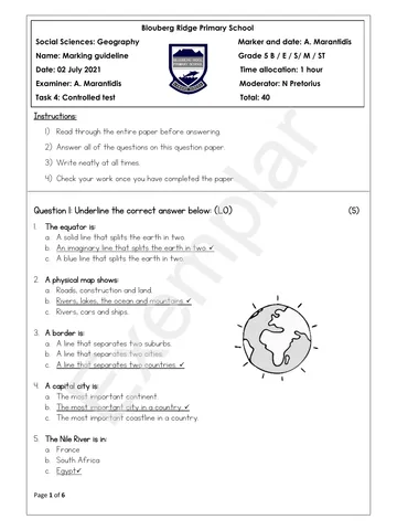
Social Sciences: Geography Marker and date: …………………
Name:…………………………….. Grade 5 B / E / S/ M / ST
Date: 02 July 2021 Time allocation: 1 hour
Examiner: A. Marantidis Moderator: …………………………
Task 4: Controlled test Total: ……….. /40
Instructions:
1) Read through the entire paper before answering.
2) Answer all of the questions on this question paper.
3) Write neatly at all times.
4) Check your work once you have completed the paper.
Question 1: Underline the correct answer below: (5)
1. The equator is:
a. A solid line that splits the earth in two.
b. An imaginary line that splits the earth in two.
c. A blue line that splits the earth in two.
2. A physical map shows:
a. Roads, construction and land.
b. Rivers, lakes, the ocean and mountains.
c. Rivers, cars and ships.
3. A border is:
a. A line that separates two suburbs.
b. A line that separates two cities.
c. A line that separates two countries.
4. A capital city is:
a. The most important continent.
b. The most important city in a country.
c. The most important coastline in a country.
5. The Nile River is in:
a. France
b. South Africa
c. Egypt
Page 1 of 6
You're offline
Skip to contentQuestion paper
Grade 5 Geography Mid Year Examination 2021
Geography · Grade 5 · June Exam · 2021. Question paper, 6 pages. Read online or download the PDF.
- Subject
- Geography
- Grade
- Grade 5
- Document type
- Question paper
- Year
- 2021
- Exam period
- June Exam
- Pages
- 6
- File size
- 760.8 KB
Loading document…
Loading document…
1 of 6
Document textSearch extracted text and jump to a page.
Question 2: Study the map below and answer the questions that follow.
MAP OF AFRICA
https://www.istockphoto.com/search/2/image?phrase=africa+map
2.1. Name a country north of South Africa. (1)
2.2. Name one Island that can be found on this map. (1)
2.3. Name 3 countries that are on the Indian oceans coastline. (3)
1.
2.
3.
Page 2 of 6
Question 3: Label the following picture showing where the following should be: (3)
3.1. The plateau.
3.2. The escarpment.
3.3. The coastal plain.
c)
b)
a)
https://www.pitlochryps.co.za/pluginAppObj/pluginAppObj_115_14/Grade-5-Geography---Task-2.pdf
Question 4: Study the river map below and answer the questions that follow.
Https://www.ck12.org/book/CK-12-Earth-Science-Concepts-For-Middle-School/section/6.8/
4.1. Explain what a river mouth is and where it leads to. (2)
4.2 Explain what is meant by a rivers ‘tributaries’? (1)
Page 3 of 6
4.3. What is the rivers ‘source’ and where does it come from? (2)
4.4. Explain what is meant by ‘higher land’ and ‘lower land’ (2)
Higher land:
Lower land:
Question 5: Match the word below with the correct description. Write the letter next to the
word. (E.g. Mountain: H) (6)
A: A dent or curve in the coast line. 1. Valley:
B: A low area between mountains. 2. Cape:
C: A higher area that is not as large as a mountain. 3. Bay:
D: A piece of highland that goes into the sea. 4. Hill:
E: A group or line of mountains. 5. Mountain peak:
F: The highest point of a mountain. 6. Mountain range:
Question 6: Study the images below and answer the questions that follow.
Picture A Picture B Picture C
https://thehungryjpeg.com/product/122256-cartoon
6.1. Explain what is meant by ‘human activities’? Mention one example in your answer. (2)
6.2. In your opinion do you think human activities affect the environment? Supply a reason
to support your opinion. (2)
Page 4 of 6
Question 7: Choose words from the word block and answer the following statements: (5)
Limpopo uphill river system plateau downhill
spot height Kwazulu Natal grid cape bay
activities waterfall Tugela
7.1. The low coastal plains are mainly in .
7.3. All the rivers and streams in a catchment area form a .
7.4. All rivers flow .
7.5 The river is located in South Africa.
7.6. A is water flowing down a mountain.
7.7. A symbol on a map to show a high point is a .
Question 8: Write a paragraph on the Marico-Bosveld dam, by using the writing frame below to
help you construct your paragraph. (5)
WRITING FRAME
(THIS PART WILL NOT BE MARKED BUT YOUR PARAGRAPH WILL)
8.1. Where is the dam is located?
8.2. How long ago it was built?
8.3. Why did they build a dam wall?
8.4. What did people grow and keep around the dam?
8.5. What happened in the dry season?
Page 5 of 6
Use your writing frame to now write a full paragraph on the Marico-Bosveld Dam:
Page 6 of 6
Recommended for this subject
Published documents with matching subject and grade metadata.
Related documents
Matched using subject, grade, language, document type and exam metadata.