1
TOM NEWBY SCHOOL
Subject Geography Examiner Mrs. v Coppenhagen
Date June 2021 Total marks 30 marks
Grade 5 Duration 1 hour
Moderator Miss Botha
Special instructions/ 1. Write as many details as possible.
Equipment 2. Read and answer ALL questions thoroughly.
3. Write neatly and legibly in blue pen.
4. Good luck! Think before you INK!
This assessment has been compiled using notes and information contained in the Tom
Newby School resource material. The marking memorandum has been compiled
accordingly. While alternative responses will be given due acknowledgement, the official
memorandum will be considered a priority document to ensure uniformity of marking.
Name: Surname: Class:
SECTION A [10]
QUESTION 1 – MATCH COLUMN B WITH COLUMN A
Match column B with column A and write only the letter next to the number, eg.1.1 F [5]
COLUMN A COLUMN B
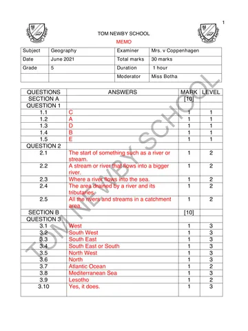
1.1 Plateau A A steep slope between a plateau and a lower
area
1.2 Escarpment B A country with no direct access to the sea
and no sea border.
1.3 Coastal plain C High, flat inland parts of a country.
1.4 Landlocked country D Low lying land that is near to the sea.
1.5 Coast E Land next to the sea.
F Land that a glacier moves along.
1.1 1.2 1.3 1.4 1.5
(5)
1
You're offline
Skip to contentQuestion paper
Grade 5 Geography Exam June 2021
Geography · Grade 5 · June Exam · 2021. Question paper, 5 pages. Read online or download the PDF.
- Subject
- Geography
- Grade
- Grade 5
- Document type
- Question paper
- Year
- 2021
- Exam period
- June Exam
- Pages
- 5
- File size
- 899.4 KB
Loading document…
Loading document…
1 of 5
Document textSearch extracted text and jump to a page.
2
QUESTION 2 [5]
Write the correct definition for the following words:
2.1 River source (1)
__________________________________________________________________________
2.2 Tributary (1)
__________________________________________________________________________
2.3 River mouth (1)
__________________________________________________________________________
2.4 Catchment area (1)
__________________________________________________________________________
2.5 River system (1)
__________________________________________________________________________
SECTION B – DIRECTION AND POLITICAL MAP OF AFRICA [10]
QUESTION 3
For each of the questions below, draw a direction finder on the map given to you (Figure 1)
with eight compass directions through the point where you would be standing. Remember to
look for the words ‘from’ or ‘of’. Provide the direction of: (6)
3.1 Egypt to Libya
3.2 Angola from Saudi
3.3 Algeria to Somalia
3.4 South-Africa from Mali
3.5 Sudan to Morocco
3.6 Chad from Angola
3.7 Name the ocean that is West of South-Africa. (1)
__________________________________________________________________________
3.8 Name the sea that separates Europe from Africa. (1)
__________________________________________________________________________
3.9 Name the landlocked country in South-Africa. (1)
__________________________________________________________________________
2
3
3.10 Does the country Madagascar form part of the continent Africa? (1)
__________________________________________________________________________
Figure 1
SECTION C – MAIN RIVERS OF SOUTH-AFRICA [10]
QUESTION 4
Use the physical map of South-Africa showing borders and provinces (Figure 2) to answer the
following questions:
4.1 Find the Gariep-Orange River on the map.
a) In which country in South-Africa is its source? (1)
_____________________________________________________________________
b) Give the name of one of its tributaries. (1)
_____________________________________________________________________
c) Which province in South-Africa has the mouth of the Gariep-Orange on its
border? (1)
_____________________________________________________________________
3
4
4.2 Look at the rivers in KwaZulu-Natal.
a) Name one river in this province. (1)
_____________________________________________________________________
b) Which mountain range is the source of these rivers? (1)
_____________________________________________________________________
c) Explain why there are many waterfalls on these rivers. (1)
_____________________________________________________________________
4.3 Look at the heights above sea level.
a) How high above sea level is Johannesburg? (1)
_____________________________________________________________________
b) Name any three places that are 200m above sea level. (3)
_____________________________________________________________________
_____________________________________________________________________
_____________________________________________________________________
Figure 2
(Platinum Social Science, 2012, P.Ranby, B. Johannesson, R. Versfeld, M. Slamgang, B. Roberts)
GRAND TOTAL [30]
4
5
Analysis of Geography Grade 5 Test (Teacher use only)
Name of learner:__________________________________
ALLOCATED MARK LEARNERS MARK
SECTION A [10]
QUESTION 1 5
QUESTION 2 5
ALLOCATED MARK LEARNERS MARK
SECTION B [10]
QUESTION 3 10
ALLOCATED MARK LEARNERS MARK
SECTION C [10]
QUESTION 4 10
TOTAL [30]
5
Recommended for this subject
Published documents with matching subject and grade metadata.
Related documents
Matched using subject, grade, language, document type and exam metadata.