Downloaded from hlayiso.com
NATIONAL SENIOR CERTIFICATE EXAMINATION
NOVEMBER 2017
NAUTICAL SCIENCE: PAPER I
Time: 3 hours 150 marks
PLEASE READ THE FOLLOWING INSTRUCTIONS CAREFULLY
1. This question paper consists of 4 pages and an Annexure Booklet of 6 pages (i–vi).
Please check that your question paper is complete.
2. Answer ALL the questions in Sections A and B.
3. Begin the answer to each new question on a new page.
4. The use of scientific calculators is permitted.
5. Alphanumeric calculators and dictionaries are NOT permitted.
6. Nautical tables may be used.
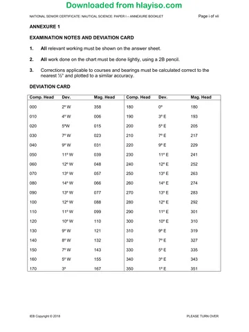
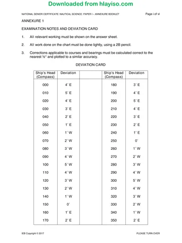
7. Use Magnetic Variation 26° W unless otherwise stated, and the Deviation Card,
Annexure 1, throughout.
8. It is in your own interest to write legibly and to present your work neatly.
REQUIREMENTS
Drawing instruments
Chart SAN 3002
ANNEXURES
1. Annexure 1 – Examination Notes and Deviation Card
2. Annexure 2 – Altitude Correction Tables
3. Annexure 3 – Conversion of Arc to Time
4. Annexure 4 – Nautical Almanac – 1987 August 17, 18, 19
5. Annexure 5 – Increments and Corrections 12m 13m
6. Annexure 6 – Increments and Corrections 4m 5m
IEB Copyright © 2017 PLEASE TURN OVER
You're offline
Skip to contentQuestion paper 
View all
Nautical Science P1 2017 hlayiso.com
Nautical Science · Grade 12 · 2017. Question paper, 4 pages. Read online or download the PDF.
- Subject
- Nautical Science
- Grade
- Grade 12
- Document type
- Question paper
- Year
- 2017
- Paper
- 1
- Publisher
- IEB
- Pages
- 4
- File size
- 334.2 KB
Loading document…
Loading document…
1 of 4
Document textSearch extracted text and jump to a page.
Downloaded from hlayiso.com
NATIONAL SENIOR CERTIFICATE: NAUTICAL SCIENCE: PAPER I Page 2 of 4
SECTION A PRACTICAL CHART WORK
QUESTION 1
A vessel is approaching Cape Town from the south steering a compass course
022° (C) at an estimated speed of 15,0 knots.
At 16:00 the vessel's position is fixed with Cape Point light bearing 084° (C) and
Slangkoppunt light bearing 042° (C).
1.1 Lay off the courses and distances from the 16:00 position to safely reach
Table Bay pilot position, north of Green Point light. (15)
1.2 Calculate the compass course to steer from the 16:00 position to the first
W.P. at the beginning of the Traffic Separation Scheme, given that:
Estimated speed is 15 knots
Current is estimated to be setting 090° (T) at 1,5 knots
A westerly wind is causing a leeway of 5°. (8)
1.3 What is the ETA at the pilot station at an average speed of 14 knots? (2)
Note: Marks are awarded for correct markings and clarity of your answers on the
chart.
[25]
QUESTION 2
A vessel carrying out underwater survey work west of Chapman's Peak, near Hout Bay,
observed the following horizontal sextant angles:
Between Hangberg ∆330 and Chapman's Peak ∆592 sextant angle 90°
Between Chapman's Peak ∆592 and Slangkoppunt light sextant angle 98°.
2.1 Plot the position of the vessel on the chart, and in your answer book record
the coordinates of that position. (12)
2.2 What is the approximate depth of water in that position? Is it greater than or
less than 30 m in depth? (3)
2.3 Describe how you would check the index error on a sextant. (10)
[25]
IEB Copyright © 2017
Downloaded from hlayiso.com
NATIONAL SENIOR CERTIFICATE: NAUTICAL SCIENCE: PAPER I Page 3 of 4
QUESTION 3
A vessel in Valsbaai steering 349° (C) at 8 knots observes a single bearing of
Whittle Rk. RACON Bn. 304° (C). The time was 13:15.
Half hour later at 13:45 the bearing of Whittle Rk. was observed to be 259° (C).
The vessel maintained the same course and speed in that time period.
3.1 Determine the vessel's position at 13:45. (19)
3.2 What is the distance off Whittle Rk. at 13:45? (1)
Note: Marks are awarded for correct markings and clarity of your answers on the
chart.
[20]
QUESTION 4
4.1 Your vessel is entering a river port and is required to pass over a sandbank
having a charted drying height of 1,1 m.
Find the height of the tide required to navigate over this sandbank if the
draught of the vessel is 10,7 m.
You are required to maintain a UKC of 2,0 m. (8)
4.2 Describe the difference between "tidal stream" and "current". (16)
4.3 Where would you find information about tidal streams for the area you are
sailing? (6)
[30]
100 marks
IEB Copyright © 2017 PLEASE TURN OVER
Downloaded from hlayiso.com
NATIONAL SENIOR CERTIFICATE: NAUTICAL SCIENCE: PAPER I Page 4 of 4
SECTION B ASTRO-NAVIGATION
QUESTION 5
A vessel in DR position 25° 35' S 012° 07' E on 18 August 1987 observed by sextant the
sun's lower limb to be 41° 07.9' when the chronometer read 09H 14M 21S.
Chronometer error was 1M 25S fast.
Sextant IE was 1,0' on the arc.
Height of eye of the observer was 12,0 m.
Determine the intercept, the direction of the position line and sketch the position through
which the position line passes.
[30]
QUESTION 6
On 18 August 1987 the setting sun was observed bearing 302° (C). The vessel
was in DR position Lat. 15° 00' N, Long. 010° 25' W steering a compass course
276° (C).
Determine the following:
6.1 The time of sunset GMT and ship's zone time. (5)
6.2 The compass error and magnetic deviation if the variation for the area was
26° W. (10)
6.3 The vessel's true course. (5)
[20]
50 marks
Total: 150 marks
IEB Copyright © 2017
Recommended for this subject
Published documents with matching subject and grade metadata.
Question paper
Nautical Science P1 2019 hlayiso.com
Question paper
Nautical Science P1 Annexure Booklet 2019 hlayiso.com
Question paper
Nautical Science P2 2019 hlayiso.com
Question paper
Nautical Science P1 2018 hlayiso.com
Question paper
Nautical Science P1 Annexure booklet 2018 hlayiso.com
Question paper
Nautical Science P2 2018 hlayiso.com
Related documents
Matched using subject, grade, language, document type and exam metadata.
Question paper
Nautical Science P1 Annexure Booklet 2017 hlayiso.com
Memorandum
Nautical Science P1 MG 2017 hlayiso.com
Question paper
Nautical Science P2 2017 hlayiso.com
Memorandum
Nautical Science P2 MG 2017 hlayiso.com
Memorandum
Nautical Science P1 Memo 2019 hlayiso.com
Memorandum
Nautical Science P1 Memo 2018 hlayiso.com
More from Grade 12 Nautical Science
Explore more published documents in this catalogue.