Downloaded from hlayiso.com
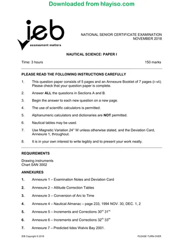
NATIONAL SENIOR CERTIFICATE EXAMINATION
NOVEMBER 2018
NAUTICAL SCIENCE: PAPER I
MARKING GUIDELINES
Time: 3 hours Marks: 150
These marking guidelines are prepared for use by examiners and sub-examiners,
all of whom are required to attend a standardisation meeting to ensure that the
guidelines are consistently interpreted and applied in the marking of candidates'
scripts.
The IEB will not enter into any discussions or correspondence about any marking
guidelines. It is acknowledged that there may be different views about some
matters of emphasis or detail in the guidelines. It is also recognised that,
without the benefit of attendance at a standardisation meeting, there may be
different interpretations of the application of the marking guidelines.
IEB Copyright © 2018 PLEASE TURN OVER
You're offline
Skip to contentMemorandum 
View all
Nautical Science P1 Memo 2018 hlayiso.com
Nautical Science · Grade 12 · 2018. Memorandum, 8 pages. Read online or download the PDF.
- Subject
- Nautical Science
- Grade
- Grade 12
- Document type
- Memorandum
- Year
- 2018
- Paper
- 1
- Publisher
- IEB
- Pages
- 8
- File size
- 884.9 KB
Loading document…
Loading document…
1 of 8
Document textSearch extracted text and jump to a page.
Downloaded from hlayiso.com
NATIONAL SENIOR CERTIFICATE: NAUTICAL SCIENCE: PAPER I – MARKING GUIDELINES Page 2 of 8
SECTION A PRACTICAL CHART WORK
QUESTION 1
Ship's Heading Robben Isl.
Lt. Bearing
Compass 132° 089°
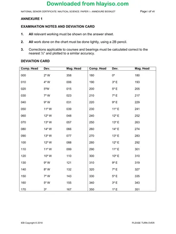
Deviation 9° W 9° W
Magnetic 123° 080°
Variation 24° W 24° W
True 099° 056°
1.1 Course to make good 057° (T) See Chart SAN 3002
Course to counter the 047° (T) See Chart SAN 3002
current
Leeway allowed 2° -
(Wind W'ly)
Course to steer 045° (T)
Variation 24° W
Magnetic course to 069° (M)
steer
Deviation 13° ½ W
Compass course to 082° ½ (C)
steer
1.2 Course from A/C to 090° (T) See Chart SAN 3002
Pilot
1.3 Dist. 05:00 to Pilot 11,0 M
Time @ 8 kts 01h 22m
05 00
ETA Pilot 06 22
IEB Copyright © 2018 PLEASE TURN OVER
Downloaded from hlayiso.com
NATIONAL SENIOR CERTIFICATE: NAUTICAL SCIENCE: PAPER I – MARKING GUIDELINES Page 3 of 8
QUESTION 2
Simonsberg/Paulsberg 347°/167°
brg.
Base angle 90° – 63° 27°
Brg. from Simonsberg 167° – 27° 140°
Brg. from Paulsberg 347° + 27° 014°
Paulsberg/Cape Point Lt. 336°/156°
brg.
Base angle 90° – 56° 34°
Brg. from Cape Point Lt. 336° + 34° 010°
Brg. from Paulsberg 156° – 34° 122°
Chart work marks
Anchor position: Lat. 34° 16,6'S Long. 018° 31,6'E
or – Whittle Rk buoy brg. 049° × 2,9'
or – Cape Point Lt. brg. 197° × 5,0'
IEB Copyright © 2018 PLEASE TURN OVER
Downloaded from hlayiso.com
NATIONAL SENIOR CERTIFICATE: NAUTICAL SCIENCE: PAPER I – MARKING GUIDELINES Page 4 of 8
QUESTION 3
V/l Hdg. Brg. Brg.
16:30 17:00
Compass 335° (C) 027° (C) 076° (C)
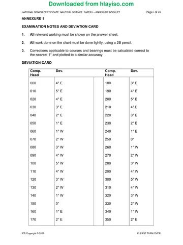
Deviation 4° E 4° E 4° E
Magnetic 339° (M) 031° (M) 080° (M)
Variation 24° W 24° W 24° W
True 315° (T) 007° (T) 056° (T)
Leeway (W'ly) 5° -
Track (T) 320° (T)
3.1 Chartwork
3.2 The vessel will pass 1 mile NE of the 29 m depth.
3.3 The 29 m depth will be abeam at 19:20
IEB Copyright © 2018 PLEASE TURN OVER
Downloaded from hlayiso.com
NATIONAL SENIOR CERTIFICATE: NAUTICAL SCIENCE: PAPER I – MARKING GUIDELINES Page 5 of 8
QUESTION 4
4.1 Draught 5,00
Clearance 0,50
Depth required 5,50
Chart depth 4,00
Height of tide 1,50
required
The earliest time to cross on the afternoon rising tide will be at
13:00 on Wednesday 28 November.
4.2 Chart datum is an arbitrarily fixed level at a port devised so that
it is below low tide level (except for very low tides). All
predicted tidal heights for any port are heights above chart
datum for that particular port. Chart datum will be different for
each port.
(or similar definition)
4.3 (b) M.H.W.S.
IEB Copyright © 2018 PLEASE TURN OVER
Downloaded from hlayiso.com
NATIONAL SENIOR CERTIFICATE: NAUTICAL SCIENCE: PAPER I – MARKING GUIDELINES Page 6 of 8
QUESTION 5
5.1 Robben Island light will display the following characteristics:
• Occulting white light changing to red on its southern sector;
• The frequency is 7 seconds;
• Height is 47 metres above sea level;
• Nominal range of the white light is 24 miles, and of the red
light 12 miles.
5.2 The safe passage past Whittle Rock is to the east.
The reason may be any one of the following:
• It is an East Cardinal buoy identified by the top marks and
light frequency.
• The buoy is positioned to protect a shallow (breaks
occasionally) patch of 3,6 m depth on the west side.
5.3 "Obsc" means obscure, and the dotted arc line adjacent
denotes the arc of the circumference of Cape Point light which
is obscured.
5.4 Variation for 1999 is 23° 32'W, increasing 2'W each year.
Therefore the variation for 2014 will be 24° 02'W.
(The answer may differ depending on the publication year of
the chart, information will refer to the centre of the compass
rose in False Bay)
5.5 "Ships replenishing stores off Table Bay should remain to the
westward of the lines running in the north-north-westerly and
south-westerly directions from a point 6 nautical miles west of
Green Point Light."
IEB Copyright © 2018 PLEASE TURN OVER
Downloaded from hlayiso.com
NATIONAL SENIOR CERTIFICATE: NAUTICAL SCIENCE: PAPER I – MARKING GUIDELINES Page 7 of 8
SECTION B ASTRO-NAVIGATION
QUESTION 6
6.1 LMT Mer. Pass. 1 Dec. 11h 49'
Long. 018° 10'E - 1h 13'
(a) GMT Mer. Pass. 1 Dec. 10h 36'
Zone GMT +1hr. 1h 00,0'
(b) Mer. Pass. Zone time 11h 36'
6.2 Dec. at Mer. Pass. S 21° 47,9'
Sext. Alt. 80° 41,7'
Index error + 1,2'
Observed altitude 80° 42.9'
Dip - 6,1'
Apparent altitude 80° 36,8'
Total correction + 16,0'
True altitude 80° 52,8'
90° 00,0'
Zenith distance ZX 9° 07,2'
Declination QX S 21° 47,9'
Lat. S 12° 40,7'
Position at Mer. Pass. 12° 40,7'S 018° 10,0'E.
6.3 05:00 Lat. 13° 45,5'S
11:36 Mer. Pass. 12° 40,7'S
D'Lat. 1° 04,8'N
Distance miles 64,8 M
Time 05:00 to 11:36 6,6 hrs
Speed 9,8 kts
IEB Copyright © 2018 PLEASE TURN OVER
Downloaded from hlayiso.com
NATIONAL SENIOR CERTIFICATE: NAUTICAL SCIENCE: PAPER I – MARKING GUIDELINES Page 8 of 8
QUESTION 7
7.1 LMT 08h 30 00
Long. 044° 20'E 03h 00 00
GMT 05h 30 00
GHA 05h 00 257° 41,0 Dec. S 21° 55,0
Inc. 32m 40s 7° 30,0 ‘d' 0,2
GHA 05h 32 40 2650 11,0 Dec. S 21° 55,2
Long. 044° 20,0
LHA 309° 31,0
A 0,42 N True brg. 095° (T)
B 0,52 S Comp brg. 083° (C)
C 0,10 S Compass 12° E
error
T Brg. S 85° E Ship's Hdg. 250° (C)
T. Brg. 095° (T) True Hdg. 262° (T)
7.2 Compass error 12° E
Var. 23° E
Dev. 11° W
Total: 150 marks
IEB Copyright © 2018
Recommended for this subject
Published documents with matching subject and grade metadata.
Memorandum
Nautical Science P1 Memo 2019 hlayiso.com
Memorandum
Nautical Science P2 Memo 2019 hlayiso.com
Memorandum
Nautical Science P2 Memo 2018 hlayiso.com
Memorandum
Nautical Science P1 MG 2017 hlayiso.com
Memorandum
Nautical Science P2 MG 2017 hlayiso.com
Question paper
Nautical Science P1 2019 hlayiso.com
Related documents
Matched using subject, grade, language, document type and exam metadata.
Question paper
Nautical Science P1 2018 hlayiso.com
Question paper
Nautical Science P1 Annexure booklet 2018 hlayiso.com
Question paper
Nautical Science P2 2018 hlayiso.com
Question paper
Nautical Science P1 Annexure Booklet 2019 hlayiso.com
Question paper
Nautical Science P1 2017 hlayiso.com
Question paper
Nautical Science P1 Annexure Booklet 2017 hlayiso.com
More from Grade 12 Nautical Science
Explore more published documents in this catalogue.