Downloaded from hlayiso.com
NATIONAL SENIOR CERTIFICATE EXAMINATION
NOVEMBER 2019
NAUTICAL SCIENCE: PAPER I
MARKING GUIDELINES
Time: 3 hours 150 marks
These marking guidelines are prepared for use by examiners and sub-examiners,
all of whom are required to attend a standardisation meeting to ensure that the
guidelines are consistently interpreted and applied in the marking of candidates'
scripts.
The IEB will not enter into any discussions or correspondence about any marking
guidelines. It is acknowledged that there may be different views about some
matters of emphasis or detail in the guidelines. It is also recognised that,
without the benefit of attendance at a standardisation meeting, there may be
different interpretations of the application of the marking guidelines.
IEB Copyright © 2019 PLEASE TURN OVER
You're offline
Skip to contentMemorandum 
View all
Nautical Science P1 Memo 2019 hlayiso.com
Nautical Science · Grade 12 · 2019. Memorandum, 8 pages. Read online or download the PDF.
- Subject
- Nautical Science
- Grade
- Grade 12
- Document type
- Memorandum
- Year
- 2019
- Paper
- 1
- Publisher
- IEB
- Pages
- 8
- File size
- 594.2 KB
Loading document…
Loading document…
1 of 8
Document textSearch extracted text and jump to a page.
Downloaded from hlayiso.com
NATIONAL SENIOR CERTIFICATE: NAUTICAL SCIENCE: PAPER I – MARKING GUIDELINES Page 2 of 8
SECTION A PRACTICAL CHARTWORK
QUESTION 1
1.1 Course Brg. of Robben Isl. Lt.
158° (C) 142° (C)
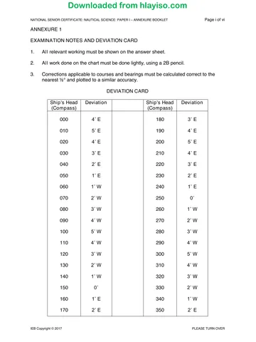
Deviation 1° E 1° E
159° (M) 143° (M)
Variation 24° W 24° W
135° (T) 119° (T)
Course to make good 144° (T)
Course to counter current 139° (T)
Leeway (W) 7° +
Course to steer 146° (T)
Var 24° W
Magnetic course 170° (M)
Dev 2° E
Compass course to steer 168° (C)
Chart
1.2 Course to the pilot station 090° 4,6 miles.
IEB Copyright © 2019 PLEASE TURN OVER
Downloaded from hlayiso.com
NATIONAL SENIOR CERTIFICATE: NAUTICAL SCIENCE: PAPER I – MARKING GUIDELINES Page 3 of 8
QUESTION 2
2.1 Simonsberg/Else Pk 90° – 75° = 15° brg 358°/178°
Simonsberg 358° + 15° = 013°
Else Pk 178° – 15° = 163°
Else Pk/Kalkbaaiberg 90° – 43° = 47° brg 185°/005°
Else Pk 005° + 47° = 052°
Kalkbaaiberg 185° – 47° = 138°
Anchor position Roman Rocks Lt. brg. 211° × 1,5'
CHART
2.2 Simon's Town breakwater light brg. 224° × 2,3'
Kalkbaai breakwater light brg. 330° × 2,2'
Nearest point of land Else Pk. Quarry radar range 1,7'
Seal Island nearest radar range 5,5'
Whittle Rock Racon 137° × 7,2'
Or any three of the above
2.3 Radar, compass bearings, echo sounder, GPS.
Any two of the above
IEB Copyright © 2019 PLEASE TURN OVER
Downloaded from hlayiso.com
NATIONAL SENIOR CERTIFICATE: NAUTICAL SCIENCE: PAPER I – MARKING GUIDELINES Page 4 of 8
QUESTION 3
Course 10:00 11:00
Compass 150° 070° 010°
Dev 0° 0° 0°
Magnetic 150° 070° 010°
Var 24° W 24° W 24° W
True 126° 046° 346°
Position at 11:00 Cape Point Lt brg 346° (T) × 7,1'
Lat 34° 28,3' S Long 018° 31,9' E
Chart
IEB Copyright © 2019 PLEASE TURN OVER
Downloaded from hlayiso.com
NATIONAL SENIOR CERTIFICATE: NAUTICAL SCIENCE: PAPER I – MARKING GUIDELINES Page 5 of 8
QUESTION 4
4.1 Draught = 2,62 m
Clearance = 1,50
Depth required = 4,12
Chart depth = 2,50
Height of tide = 1,62 m
From the Tide Tables, cross at 15h 30m on 25 December
4.2 4.2.1 Spring tide occurs at: Full moon when the attractive forces of the
sun and moon combine.
New moon when the sun and moon are in
conjunction.
4.2.2 Neap tide occurs at: Moon's 1st quarter when the gravitational
forces are acting at 90°.
Moon's 3rd quarter when the sun and moon
are in quadrature.
IEB Copyright © 2019 PLEASE TURN OVER
Downloaded from hlayiso.com
NATIONAL SENIOR CERTIFICATE: NAUTICAL SCIENCE: PAPER I – MARKING GUIDELINES Page 6 of 8
QUESTION 5
5.1 Kaap Hangklip Lt. (Fl. 10s 34m 25M)
Flash white light with a frequency of 10 seconds
Height of light 34 meters above MHWS
Range of visibility 25 miles
5.2 Cape Point light southern range shows (F. R. 77m 15M)
Fixed red light
Height of light 77 meters above MHWS
Range of visibility is 15 miles
5.3 No. 4 Anchorage Hazardous Block
e.g. Breakwater Lt. brg 177° × 3,7'
Or similar position within the limits of No. 4 Anchorage + water depth
5.4 1 852 metres
5.5 0,9 miles
IEB Copyright © 2019 PLEASE TURN OVER
Downloaded from hlayiso.com
NATIONAL SENIOR CERTIFICATE: NAUTICAL SCIENCE: PAPER I – MARKING GUIDELINES Page 7 of 8
SECTION B ASTRO-NAVIGATION
QUESTION 6
LMT 09h 52m GHA = 299° 04,0' Dec = 12° 54,9' N
08:00
Long 15° 10' E 01 01 Inc 51 m = 12° 45,0' 'd' = 0,7'
-
GMT 08h 51m GHA = 311° 49,0' Dec = 12° 54,2' N
08:51
Long = 15° 10,0'
15°10'
LHA = 326° 59,0' (5)
A = 0.819 N True brg 042 1/2°
B = 0.421 N Compass brg 069°
C = 1.240 N Error 26 1/2° W
Az. = N 42 1/2° E
042 1/2°
6.1 6.2
Compass Hdg 340° Compass error 26 1/2° W
Compass error 26 1/2° W Var 23° W
True heading 313 1/2° Deviation 3 1/2° W
IEB Copyright © 2019 PLEASE TURN OVER
Downloaded from hlayiso.com
NATIONAL SENIOR CERTIFICATE: NAUTICAL SCIENCE: PAPER I – MARKING GUIDELINES Page 8 of 8
QUESTION 7
7.1 7.1.1 LMT Mer Pass 12h 04m
Long 4 38 +
069°30'W
GMT Mer 16h 42m (7.1.1)
Pass
Zone 5 00 –
Zone time MP 11h 42m (7.1.1)
7.1.2 Sext Alt = 72° 51,2' Dec 13° 07,9' N
i.e. (off) = 1,5' + 'd' 0,6' –
Obs Alt = 72° 52,7' Dec 13° 07,3' N
dip (12,5m) = 6,2' –
App Alt = 72° 46,5'
Total corr = 15,6' +
True alt = 73° 02,1'
90° 00,0'
ZX = 16° 57,9'
Dec = 13° 07,3' N
Lat. = 30° 05,2' N (7.1.2)
7.2
Total: 150 marks
IEB Copyright © 2019
Recommended for this subject
Published documents with matching subject and grade metadata.
Memorandum
Nautical Science P2 Memo 2019 hlayiso.com
Memorandum
Nautical Science P1 Memo 2018 hlayiso.com
Memorandum
Nautical Science P2 Memo 2018 hlayiso.com
Memorandum
Nautical Science P1 MG 2017 hlayiso.com
Memorandum
Nautical Science P2 MG 2017 hlayiso.com
Question paper
Nautical Science P1 2019 hlayiso.com
Related documents
Matched using subject, grade, language, document type and exam metadata.
Question paper
Nautical Science P1 Annexure Booklet 2019 hlayiso.com
Question paper
Nautical Science P2 2019 hlayiso.com
Question paper
Nautical Science P1 2018 hlayiso.com
Question paper
Nautical Science P1 Annexure booklet 2018 hlayiso.com
Question paper
Nautical Science P1 2017 hlayiso.com
Question paper
Nautical Science P1 Annexure Booklet 2017 hlayiso.com
More from Grade 12 Nautical Science
Explore more published documents in this catalogue.