Downloaded from hlayiso.com
NATIONAL SENIOR CERTIFICATE EXAMINATION
NOVEMBER 2018
NAUTICAL SCIENCE: PAPER I
Time: 3 hours 150 marks
PLEASE READ THE FOLLOWING INSTRUCTIONS CAREFULLY
1. This question paper consists of 5 pages and an Annexure Booklet of 7 pages (i–vii).
Please check that your question paper is complete.
2. Answer ALL the questions in Sections A and B.
3. Begin the answer to each new question on a new page.
4. The use of scientific calculators is permitted.
5. Alphanumeric calculators and dictionaries are NOT permitted.
6. Nautical tables may be used.
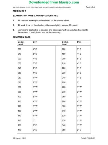
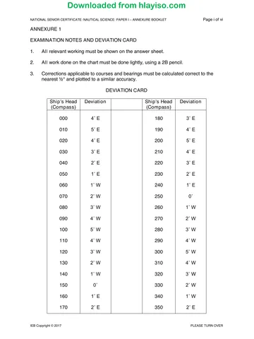
7. Use Magnetic Variation 24° W unless otherwise stated, and the Deviation Card,
Annexure 1, throughout.
8. It is in your own interest to write legibly and to present your work neatly.
REQUIREMENTS
Drawing instruments
Chart SAN 3002
ANNEXURES
1. Annexure 1 – Examination Notes and Deviation Card
2. Annexure 2 – Altitude Correction Tables
3. Annexure 3 – Conversion of Arc to Time
4. Annexure 4 – Nautical Almanac – page 233, 1994 NOV. 30, DEC. 1, 2
5. Annexure 5 – Increments and Corrections 30m 31m
6. Annexure 6 – Increments and Corrections 32m 33m
7. Annexure 7 – Predicted tides Walvis Bay 2001.
IEB Copyright © 2018 PLEASE TURN OVER
You're offline
Skip to contentQuestion paper 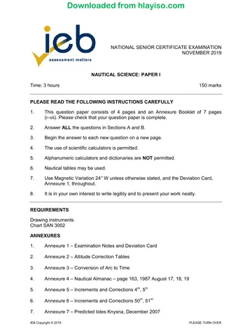
View all
Nautical Science P1 2018 hlayiso.com
Nautical Science · Grade 12 · 2018. Question paper, 5 pages. Read online or download the PDF.
- Subject
- Nautical Science
- Grade
- Grade 12
- Document type
- Question paper
- Year
- 2018
- Paper
- 1
- Publisher
- IEB
- Pages
- 5
- File size
- 102.1 KB
Loading document…
Loading document…
1 of 5
Document textSearch extracted text and jump to a page.
Downloaded from hlayiso.com
NATIONAL SENIOR CERTIFICATE: NAUTICAL SCIENCE: PAPER I Page 2 of 5
SECTION A PRACTICAL CHART WORK
QUESTION 1
Approaching Cape Town on a Compass course 132° (C) at 05:00 the ship's
observed position is Robben Island Lt. bearing 089° (C) × 11,0 miles.
Using the Chart SAN 3002 provided, plot this position and determine:
1.1 The compass course to steer to the next alter course position
Robben Island Lt. bearing 053° (T) × 5,8 miles.
• Speed through the water is 10 knots;
• Current is estimated to be setting 170° (T) at 2 knots;
• Estimated leeway from a Westerly wind is 2°. (18)
1.2 From this last alter course position, what is the true course to steer to arrive
at the pilot rendezvous position with the Main Breakwater Lt. (Fl.G.2s.5M)
bearing 128° (T) × 2,2 miles? (2)
1.3 What is the ETA at the pilot rendezvous position from the 05:00 position at
an average speed of 8 knots? (5)
[25]
QUESTION 2
The navigator on a minesweeper at anchor off Smitswinkel Bay observes the
following horizontal sextant angles:
between the beacons on Simonsberg Δ546 and Paulsberg Δ366 is 63°;
and between Cape Point lighthouse and Paulsberg Δ366 is 56°.
Determine the anchored position of the minesweeper.
[20]
IEB Copyright © 2018
Downloaded from hlayiso.com
NATIONAL SENIOR CERTIFICATE: NAUTICAL SCIENCE: PAPER I Page 3 of 5
QUESTION 3
A vessel steering 335° (C) and making 5° leeway in a Westerly wind, observes
Kaap Hangklip light bearing 027° (C) at 16:30.
At 17:00 Kaap Hangklip light was observed bearing 076° (C).
The vessel maintained an average engine speed of 18 knots during this period.
The current was estimated to be setting 138° (T) × 2,2 knots.
3.1 Plot the vessel's position at 17:00. (15)
3.2 How far off the 29 m depth shown on the chart NE of Rocky Bank will the
vessel pass if it maintains its course and speed? (3)
3.3 What is the estimated time that this 29 m depth will be abeam at the current
course and speed? (2)
[20]
QUESTION 4
4.1 Your vessel is anchored off the Port of Walvis Bay waiting to enter the port.
The minimum depth in the approach channel is 4,00 m.
The vessel's draught is 5,00 m, and you are required to maintain a minimum
clearance under the keel of 0,50 m.
What is the earliest time the vessel may cross this point on the rising tide on
the afternoon of Wednesday 28 November 2001? (10)
4.2 Define chart datum. (3)
4.3 Which reference point is the elevated height of a lighthouse measured from?
(a) Chart datum OR
(b) M.H.W.S. (2)
[15]
IEB Copyright © 2018 PLEASE TURN OVER
Downloaded from hlayiso.com
NATIONAL SENIOR CERTIFICATE: NAUTICAL SCIENCE: PAPER I Page 4 of 5
QUESTION 5
The following questions refer to information found on the chart supplied, Chart
SAN 3002.
5.1 Describe the characteristics of Robben Island light. (6)
5.2 Which is the safe side to pass Whittle Rock buoy, Q(3)v10s Bell, in
Valsbaai? Give a reason why this should be the safe side. (4)
5.3 What is the meaning of the abbreviation "Obsc" shown on the chart south of
Slangkoppunt? (3)
5.4 What is the corrected magnetic variation for Valsbaai for the year 2014? (3)
5.5 There is a "Replenishment Area" to the west of Table Bay. What does the
note say about this area? (4)
[20]
100 marks
IEB Copyright © 2017 PLEASE TURN OVER
Downloaded from hlayiso.com
NATIONAL SENIOR CERTIFICATE: NAUTICAL SCIENCE: PAPER I Page 5 of 5
SECTION B ASTRO-NAVIGATION
QUESTION 6
At 05:00 local zone time (GMT + 1) on 1 December 1994, the ship's position from morning
stars was found to be 13° 45,5'S 018° 10,0'E.
The ship is steering a course of 000° (T) and estimated speed of 11 knots.
6.1 What is the time of meridian passage on 1 December 1994: (1)
(a) GMT? (2)
(b) Ship's zone time? (2) (5)
6.2 The sun's lower limb was observed to the south at meridian passage to be
80° 41,7' by sextant.
i.e. +1,2'
height of eye 12 m above sea level.
Determine the ship's position at meridian passage. (15)
6.3 Calculate the distance and speed made good since the morning star
position at 05:00 if the vessel steered 000° (T). (5)
[25]
QUESTION 7
At 08:30 local ship's time on 2 December 1994, in DR position 27° 00'S 044° 20'E,
the officer of the watch observed the sun bearing 083° (C) when the ship's head
was 250° (C).
7.1 What is the true heading of the ship at this time? (20)
7.2 What is the compass deviation if the magnetic variation for this region is
23°E? (5)
[25]
50 marks
Total: 150 marks
IEB Copyright © 2018
Recommended for this subject
Published documents with matching subject and grade metadata.
Question paper
Nautical Science P1 2019 hlayiso.com
Question paper
Nautical Science P1 Annexure Booklet 2019 hlayiso.com
Question paper
Nautical Science P2 2019 hlayiso.com
Question paper
Nautical Science P1 Annexure booklet 2018 hlayiso.com
Question paper
Nautical Science P2 2018 hlayiso.com
Question paper
Nautical Science P1 2017 hlayiso.com
Related documents
Matched using subject, grade, language, document type and exam metadata.
Memorandum
Nautical Science P1 Memo 2018 hlayiso.com
Question paper
Nautical Science P1 Annexure Booklet 2017 hlayiso.com
Memorandum
Nautical Science P2 Memo 2018 hlayiso.com
Memorandum
Nautical Science P1 Memo 2019 hlayiso.com
Memorandum
Nautical Science P1 MG 2017 hlayiso.com
Question paper
Nautical Science P2 2017 hlayiso.com
More from Grade 12 Nautical Science
Explore more published documents in this catalogue.