Downloaded from hlayiso.com
NATIONAL SENIOR CERTIFICATE EXAMINATION
NOVEMBER 2019
NAUTICAL SCIENCE: PAPER I
Time: 3 hours 150 marks
PLEASE READ THE FOLLOWING INSTRUCTIONS CAREFULLY
1. This question paper consists of 4 pages and an Annexure Booklet of 7 pages
(i–vii). Please check that your question paper is complete.
2. Answer ALL the questions in Sections A and B.
3. Begin the answer to each new question on a new page.
4. The use of scientific calculators is permitted.
5. Alphanumeric calculators and dictionaries are NOT permitted.
6. Nautical tables may be used.
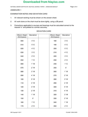
7. Use Magnetic Variation 24° W unless otherwise stated, and the Deviation Card,
Annexure 1, throughout.
8. It is in your own interest to write legibly and to present your work neatly.
REQUIREMENTS
Drawing instruments
Chart SAN 3002
ANNEXURES
1. Annexure 1 – Examination Notes and Deviation Card
2. Annexure 2 – Altitude Correction Tables
3. Annexure 3 – Conversion of Arc to Time
4. Annexure 4 – Nautical Almanac – page 163, 1987 August 17, 18, 19
5. Annexure 5 – Increments and Corrections 4m, 5m
6. Annexure 6 – Increments and Corrections 50m, 51m
7. Annexure 7 – Predicted tides Knysna, December 2007
IEB Copyright © 2019 PLEASE TURN OVER
You're offline
Skip to contentQuestion paper 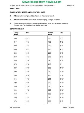
View all
Nautical Science P1 2019 hlayiso.com
Nautical Science · Grade 12 · 2019. Question paper, 4 pages. Read online or download the PDF.
- Subject
- Nautical Science
- Grade
- Grade 12
- Document type
- Question paper
- Year
- 2019
- Paper
- 1
- Publisher
- IEB
- Pages
- 4
- File size
- 100.7 KB
Loading document…
Loading document…
1 of 4
Document textSearch extracted text and jump to a page.
Downloaded from hlayiso.com
NATIONAL SENIOR CERTIFICATE: NAUTICAL SCIENCE: PAPER I Page 2 of 4
SECTION A PRACTICAL CHARTWORK
QUESTION 1
A vessel is approaching Cape Town on a compass course 158° (C) at 05:00 and
the observed position is Robben Island Lt. bearing 142° (C) × 11,5 miles. Using
the Chart SAN 3002 provided, plot the position and determine the following:
1.1 The compass course to steer to the next alter course position, Robben
Island Lt. bearing 043° (T) × 4,9', given:
• speed through the water is 10 knots
• current is estimated to be setting 170° (T) at 2 knots
• estimated leeway from a Westerly wind is 7° (15)
1.2 From this last alter course position, what is the true course to steer to arrive
at the pilot rendezvous position north of Green Point Lighthouse? Plot the
course on the chart. (5)
[20]
QUESTION 2
2.1 Your vessel has anchored in Simon's Bay. The following horizontal sextant
angles were observed between:
Simonsberg ∆ 546 and Else Pk. ∆ 303 is 75°
Else Pk. ∆ 303 and Kalkbaaiberg ∆ 515 is 43°
What is the position of the vessel in terms of range and bearing of Roman
Rocks Light? (15)
2.2 Apart from Roman Rocks Light, identify three other salient points on the
chart to monitor your anchorage position. (3)
2.3 Name two navigation instruments on the bridge that you could use to
monitor your vessel's position whilst at anchor. (2)
[20]
QUESTION 3
A vessel steering 150° (C) observed at 10:00 Cape Point Lt. bearing 070° (C).
At 11:00 Cape Point Lt. was observed bearing 010° (C). The vessel maintained a
course 150° (C) and engine speed of 7 knots throughout. The current was known
to set 270° (T) at 1,0 knot.
Determine the vessel's position at 11:00.
[20]
IEB Copyright © 2019
Downloaded from hlayiso.com
NATIONAL SENIOR CERTIFICATE: NAUTICAL SCIENCE: PAPER I Page 3 of 4
QUESTION 4
4.1 The draught of your vessel is 2,62 m and you are required to navigate
through Knysna Heads with a minimum chart depth of 2,5 m.
What is the earliest time on a rising tide on the afternoon of Tuesday
25 December 2007 that your vessel may transit with an under-keel
clearance of 1,5 m? (16)
4.2 During which phases of the moon do the following occur?
4.2.1 Spring tide (2)
4.2.2 Neap tide (2)
[20]
QUESTION 5
5.1 Describe the characteristics of Kaap Hangklip Lighthouse (Lat 34° 32,2' S
Long 018° 49,7' E). (5)
5.2 Cape Point Lighthouse is observed bearing 000° (T) × 6,0M. What
characteristics would this light show from this position? (5)
5.3 Select a safe anchorage position in Table Bay for a container vessel
carrying hazardous cargo and a deep draught of 13 m.
Mark the position on the Chart SAN 3002 provided, and write down on your
Answer Book the bearing and range off the Main Breakwater Lt. (Fl. G. 2s 5M). (7)
5.4 How many metres are there in one nautical mile? (2)
5.5 If a ship at anchor is 9 cables away from a buoy, how far is this in nautical
miles? (1)
[20]
100 marks
IEB Copyright © 2019 PLEASE TURN OVER
Downloaded from hlayiso.com
NATIONAL SENIOR CERTIFICATE: NAUTICAL SCIENCE: PAPER I Page 4 of 4
SECTION B ASTRO-NAVIGATION
QUESTION 6
On 19 August 1987 at 09:52 LMT in DR position 28° 00' S 015° 10' E the Sun was
observed to bear 069° (C) when the vessel was heading 340° (C).
6.1 What is the true heading of the vessel at this time? (15)
6.2 If the magnetic variation is 23° W, what is the deviation of the compass for
this heading? (10)
[25]
QUESTION 7
On 18 August 1987 in DR position 29° 32' N 069° 30' W the lower limb of the Sun
was observed at meridian passage south of the observer at a sextant altitude of
72° 51,2'.
The index error of the sextant was 1,5' off the arc, and the observer's height of eye
was 12,5m.
7.1 Determine the following:
7.1.1 The GMT and Zone Time of meridian passage (5)
7.1.2 The vessel's latitude at meridian passage (15)
7.2 Illustrate your answer by means of a sketch on the plane of the celestial
horizon showing the following:
7.2.1 The celestial equator (Q) (1)
7.2.2 The Sun's declination (1)
7.2.3 The zenith position (Z) (1)
7.2.4 The position of the Sun (X) (1)
7.2.5 The elevated pole (P) (1)
[25]
50 marks
Total: 150 marks
IEB Copyright © 2019
Recommended for this subject
Published documents with matching subject and grade metadata.
Question paper
Nautical Science P1 Annexure Booklet 2019 hlayiso.com
Question paper
Nautical Science P2 2019 hlayiso.com
Question paper
Nautical Science P1 2018 hlayiso.com
Question paper
Nautical Science P1 Annexure booklet 2018 hlayiso.com
Question paper
Nautical Science P2 2018 hlayiso.com
Question paper
Nautical Science P1 2017 hlayiso.com
Related documents
Matched using subject, grade, language, document type and exam metadata.
Memorandum
Nautical Science P1 Memo 2019 hlayiso.com
Question paper
Nautical Science P1 Annexure Booklet 2017 hlayiso.com
Memorandum
Nautical Science P2 Memo 2019 hlayiso.com
Memorandum
Nautical Science P1 Memo 2018 hlayiso.com
Memorandum
Nautical Science P1 MG 2017 hlayiso.com
Question paper
Nautical Science P2 2017 hlayiso.com
More from Grade 12 Nautical Science
Explore more published documents in this catalogue.