Downloaded from hlayiso.com
NATIONAL SENIOR CERTIFICATE EXAMINATION
NOVEMBER 2017
NAUTICAL SCIENCE: PAPER I
MARKING GUIDELINES
Time: 3 hours 150 marks
These marking guidelines are prepared for use by examiners and sub-examiners,
all of whom are required to attend a standardisation meeting to ensure that the
guidelines are consistently interpreted and applied in the marking of candidates'
scripts.
The IEB will not enter into any discussions or correspondence about any marking
guidelines. It is acknowledged that there may be different views about some
matters of emphasis or detail in the guidelines. It is also recognised that,
without the benefit of attendance at a standardisation meeting, there may be
different interpretations of the application of the marking guidelines.
IEB Copyright © 2017 PLEASE TURN OVER
You're offline
Skip to contentMemorandum 
View all
Nautical Science P1 MG 2017 hlayiso.com
Nautical Science · Grade 12 · 2017. Memorandum, 7 pages. Read online or download the PDF.
- Subject
- Nautical Science
- Grade
- Grade 12
- Document type
- Memorandum
- Year
- 2017
- Paper
- 1
- Publisher
- IEB
- Pages
- 7
- File size
- 299.6 KB
Loading document…
Loading document…
1 of 7
Document textSearch extracted text and jump to a page.
Downloaded from hlayiso.com
NATIONAL SENIOR CERTIFICATE: NAUTICAL SCIENCE: PAPER I – MARKING GUIDELINES Page 2 of 7
SECTION A PRACTICAL CHART WORK
QUESTION 1
1.1
COURSE Cape Point brg. Slangkoppunt Lt
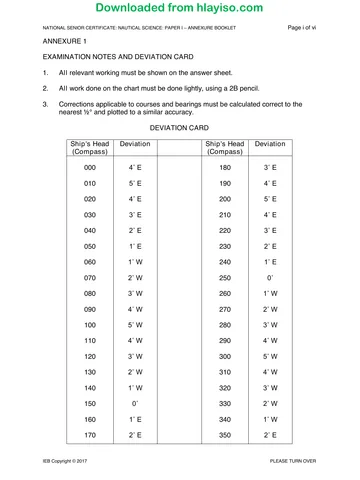
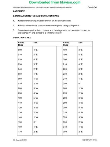
Compass 16:00 022° 084° 042°
Deviation 4° E 4° E 4° E
Magnetic 026° 088° 046°
Variation 26° W 26° W 26° W
True 000° 062° 020°
16:00 to WP.1 course to make good 008° (T) 29,6 m
WP.1 to WP.2 course to make good 030° (T) 9,7 m
WP.2 to WP.3 (Pilot) course to make good 090° (T) 2,7 m
Total distance = 42,0 m. (See chart for full answer)
1.2 From 16:00 to WP.1
Course to make good 008°(T)
Course to counter current 001°(T) See chart
Leeway 5° -
Course to steer 356°(T)
Variation 26° W
Magnetic course 022°(M)
Deviation 4° E
Compass course to steer 018°(C)
1.3 Distance to go from 16:00 is 42,0 m
Speed 14 kts, duration 3 hrs, ETA Pilot 19:00
IEB Copyright © 2017 PLEASE TURN OVER
Downloaded from hlayiso.com
NATIONAL SENIOR CERTIFICATE: NAUTICAL SCIENCE: PAPER I – MARKING GUIDELINES Page 3 of 7
Q1 (ctd.)
IEB Copyright © 2017 PLEASE TURN OVER
Downloaded from hlayiso.com
NATIONAL SENIOR CERTIFICATE: NAUTICAL SCIENCE: PAPER I – MARKING GUIDELINES Page 4 of 7
QUESTION 2
2.1 Bearing between Hangberg & Chapman's 148/328°
Dissect at 90° for centre of position circle
Bearing between Chapman’s Peak & Slangkoppunt 030/210°
90° – 98° = 8°
Slangkop 030° + 8° = 038°
Chapman's Peak 210° – 8° = 202°
V/l position 34° 06' S 018° 20' E (see chart for full answer)
2.2 Depth of water in that position is ≥30 m.
2.3 The index error will be checked by observing a star directly through the
sextant with the following procedure:
• Set the sextant index arm to 0°.
• Observe the star and adjust the index arm to bring the star and the
reflected object together so the two coincide perfectly.
• The reading will then be the Index Error (IE).
If it is 0° there is no IE. If the reading is +ve, or ON the arc, then the IE is
subtracted. If it is –ve, or OFF the arc, then the IE is added.
QUESTION 3
3.1
Course 13:15 Bearing 13:45 Bearing
Compass 349° 304° 259°
Deviation 2° E 2° E 2° E
Magnetic 351° 306° 261°
Variation 26° W 26° W 26° W
True 325° 280° 235°
Position at 13:45 34° 12.6'S 018° 38'E (See chart for full answer)
3.2 Distance off Whittle Rk. at 13:45 is 3,8 miles.
IEB Copyright © 2017 PLEASE TURN OVER
Downloaded from hlayiso.com
NATIONAL SENIOR CERTIFICATE: NAUTICAL SCIENCE: PAPER I – MARKING GUIDELINES Page 5 of 7
QUESTION 4
4.1 Height of tide required = Draught + UKC + drying height
= 10,7 + 2,0 + 1,1
= 13,8 m
4.2 • Currents are permanent or seasonal horizontal movements of water
flowing in a particular direction.
• The result is a uniform movement of water in a given direction that
transports a vessel bodily without affecting the ship's head.
• Tidal streams are also the horizontal movement of water but caused by
tidal forces.
• They can be rectilinear (flowing in two directions called ebb and flood),
or rotary, changing direction 360° in a cycle.
4.3 Information about tidal streams and currents can be found on the chart, in
the Sailing Directions and in a special Tidal Stream Atlas.
IEB Copyright © 2017 PLEASE TURN OVER
Downloaded from hlayiso.com
NATIONAL SENIOR CERTIFICATE: NAUTICAL SCIENCE: PAPER I – MARKING GUIDELINES Page 6 of 7
SECTION B ASTRO-NAVIGATION
QUESTION 5
Observation Sun
09h 14m
Chron (given)
21s
09h 14m
Chron (AM) 18.08.1987
21s
− 01m
Error (fast)
25s
09h 12m
UT/GMT 18.08.1987 (Z)
56s
sin Hc = cos LHA ∙ cos L ∙ cos D − sin L · sin D
Tab GHA 314° 00,8’ or sin Hc = (cos LHA − 1) ∙ cos L ∙ cos D + cos ( L + D)
+ 003°
HA Inc
14,0’
+ 012° LHA >
E Longitude sin Hc = (0,65672)
07,0’ 180°
East of
LHA 329° 21,8’ Hc = 41° 03’ 01,2”
Ship
Tab Dec N 13° 13,5’ N Hc ⇒ 41° 03,0’
− 000°
(d − 0,8’) Corr X
00,2’
Dec N 13° 13,3’ Q cos CZD = cos LHA ∙ cos L ∙ cos D − sin L · sin D
ZX = QZ +
DR Latitude 25° 35,0’ S QX
Z or cos CZD = (cos LHA − 1) ∙ cos L ∙ cos D + cos ( L + D)
Lat + Dec 38° 48,3’ N ZX = (L + D) S
Lat and Dec S/N Opp − cos CZD = (0,65672)
CZD = 48° 56’ 58,8”
A = |Tan L ÷ Tan
HA|
0,80836 N CZD ⇒ 48° 57,0’
B = |Tan D ÷ Sin
HA|
0,46105 N
C=A+B 1,26941 N
∠Z 41,13386°
(Nearest
Zc N 41° E
½°)
(Nearest LOP
Zn 041°T 131°T ~ 311°T
½°) Direction
Hs LL 41° 07,9’
IE (on) − 01,0’
OA LL 41° 06,9’
Dip (12,0m) − 06,1’
AA LL 41° 00,8’
TC LL
+ 14,9’
(Aug)
Ho 41° 15,7’ TZD 48° 44,3’
Hc 41° 03,0’ CZD 48° 57,0’
12,7 miles 12,7 miles
Intercept Intercept
Towards Towards
(Ho > Hc) (TZD < CZD)
IEB Copyright © 2017 PLEASE TURN OVER
Downloaded from hlayiso.com
NATIONAL SENIOR CERTIFICATE: NAUTICAL SCIENCE: PAPER I – MARKING GUIDELINES Page 7 of 7
QUESTION 6
6.1 LMT Sunset 15° N 18H 22M
Long. 10° 25' W + 42M
GMT 19H 04M
Zone (+1) - 1H 00M
Sunset v/l time 18H 04M
Dec 18 Aug 19:00 13° 05.4'
'd' (-0.8) 00.1'
Dec 19:04 13° 05.3'
6.2 Sin Amp. = Sin Dec. / Cos Lat
= Sin 13° 05.4' / Cos 15°
= 0.234470708
Amp. = W13 1/2° N
True brg. = 283 1/2°
Comp. brg. = 302°
Comp. error = 18 1/2° W
Var. = 26° W
Dev. = 7 1/2° E
6.3 Comp. course 276°(C)
Error 18 1/2° W
True course 257 1/2°(T)
Total: 150 marks
IEB Copyright © 2017
Recommended for this subject
Published documents with matching subject and grade metadata.
Memorandum
Nautical Science P1 Memo 2019 hlayiso.com
Memorandum
Nautical Science P2 Memo 2019 hlayiso.com
Memorandum
Nautical Science P1 Memo 2018 hlayiso.com
Memorandum
Nautical Science P2 Memo 2018 hlayiso.com
Memorandum
Nautical Science P2 MG 2017 hlayiso.com
Question paper
Nautical Science P1 2019 hlayiso.com
Related documents
Matched using subject, grade, language, document type and exam metadata.
Question paper
Nautical Science P1 2017 hlayiso.com
Question paper
Nautical Science P1 Annexure Booklet 2017 hlayiso.com
Question paper
Nautical Science P2 2017 hlayiso.com
Question paper
Nautical Science P1 Annexure Booklet 2019 hlayiso.com
Question paper
Nautical Science P1 2018 hlayiso.com
Question paper
Nautical Science P1 Annexure booklet 2018 hlayiso.com
More from Grade 12 Nautical Science
Explore more published documents in this catalogue.