
Mock
hlayiso mock exams
Practice Series:
Grade 11 Exam Preparation
WWW.HLAYISO.COM
NATIONAL
SENIOR CERTIFICATE
GRADE 11
GEOGRAPHY P2
NOVEMBER EXAMINATION 2026 (MOCK)
MARKS: 150
TIME: 3 hours
This question paper consists of 16 pages.
Copyright reserved Please turn over
Skip to contentAll 2026 papers 
View all

Geography Grade 11 P2 November Mock 2026 QP (Eng)
Grade 11 Geography Paper 2 question paper from the November Mock Exam 2026 (English), 16 pages. Read online or download the free PDF.
Geography · Grade 11 · November Mock Exam · 2026 · English. Question paper, 16 pages. Read online or download the PDF.
- Subject
- Geography
- Grade
- Grade 11
- Language
- English
- Document type
- Question paper
- Year
- 2026
- Exam period
- November Mock Exam
- Paper
- 2
- Publisher
- Hlayiso
- Curriculum
- CAPS
- Pages
- 16
- File size
- 870.4 KB
Free to read online, no sign-up needed
Loading document…
Loading document…
1 of 16
This exam
November Mock Exam 2026
- Paper 1Question paperAddendumMemo
- Paper 2Question paperAddendumMemo
Document textSearch extracted text and jump to a page.
Geography/P2 2 Hlayiso/Mock 2026
NSC Mock
INSTRUCTIONS AND INFORMATION
1. This question paper consists of TWO sections.
SECTION A
QUESTION 1: DEVELOPMENT GEOGRAPHY (60)
QUESTION 2: RESOURCES AND SUSTAINABILITY (60)
SECTION B
QUESTION 3: GEOGRAPHICAL SKILLS AND TECHNIQUES (30)
2. Answer ALL THREE questions.
3. ALL diagrams are included in the QUESTION PAPER.
4. Leave a line between the subsections of questions answered.
5. Start EACH question at the top of a NEW page.
6. Number the answers correctly according to the numbering system used in this question
paper.
7. Do NOT write in the margins of the ANSWER BOOK.
8. Draw fully labelled diagrams when instructed to do so.
9. Answer in FULL SENTENCES, except when you have to state, name, identify or list.
10. Units of measurement MUST be indicated in your final answer, e.g. 1 020 hPa, 14 ◦ C
and 45 m.
11. You may use a non-programmable calculator.
12. You may use a magnifying glass.
13. Write neatly and legibly.
SPECIFIC INSTRUCTIONS AND INFORMATION FOR SECTION B
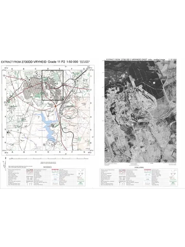
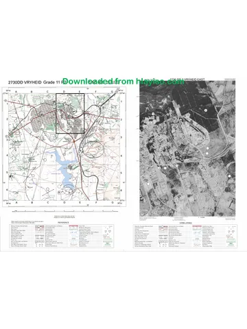
14. A 1 : 50 000 topographical map extract of 2529CC EMALAHLENI and a 1 : 10 000
orthophoto map extract of a part of the mapped area are provided on one A3 sheet,
supplied with this mock as Geography Gr11 P2 Mock 2026 Map (2529CC Emalahleni).
The map sheet was first used in the 2025 Eastern Cape November examination. Print
it on A3 paper at 100% (actual size).
15. The area demarcated in RED on the topographical map represents the area covered
by the orthophoto map.
16. Ignore the letters already printed on the maps (e.g. P, Q, R and S), unless a question
refers to them.
17. Show ALL calculations. Marks will be allocated for steps in calculations.
Copyright reserved Please turn over
Geography/P2 3 Hlayiso/Mock 2026
NSC Mock
SECTION A
QUESTION 1: DEVELOPMENT GEOGRAPHY
1.1 Complete the statements in COLUMN A with the options in COLUMN
B. Write only Y or Z next to the question numbers (1.1.1 to 1.1.8) in the
ANSWER BOOK, e.g. 1.1.9 Y.
COLUMN A COLUMN B
1.1.1 A country with high incomes, Y developed
a high standard of living and Z developing
well-developed infrastructure is a
… country.
1.1.2 The imaginary line that divides the Y Equator
richer countries from the poorer Z Brandt Line
countries of the world is the …
1.1.3 A composite indicator that Y GNI per capita
combines life expectancy, Z Human
education and income per person Development
is the … Index (HDI)
1.1.4 The number of babies per 1 000 Y infant mortality
live births who die before their first Z rate
birthday is the … birth rate
1.1.5 A Gini coefficient close to 1 Y equal income
indicates … Z distribution
high income
inequality
1.1.6 Development that meets the Y sustainable
needs of the present without Z development
compromising the needs of future economic growth
generations is …
1.1.7 A tax that a government places on Y quota
imported goods is a/an … Z tariff
1.1.8 Aid that must be used to buy Y tied aid
goods and services from the donor Z emergency aid
country is …
(8 x 1) (8)
Copyright reserved Please turn over
Geography/P2 4 Hlayiso/Mock 2026
NSC Mock
1.2 Refer to the table below showing selected development indicators for
four countries, P, Q, R and S. Various options are provided as possible
answers to the following questions. Choose the answer and write only the
letter (A–D) next to the question numbers (1.2.1 to 1.2.7) in the ANSWER
BOOK, e.g. 1.2.8 D.
Indicator P Q R S
GNI per capita (US$) 48 500 6 200 1 100 14 800
Life expectancy (years) 82 64 58 76
Adult literacy rate (%) 99 87 52 96
Infant mortality rate (per 1 000) 3 27 62 9
Human Development Index (HDI) 0,94 0,70 0,45 0,82
Workers in the primary sector (%) 2 21 68 9
[Source: Examiner’s own data (fictional countries)]
1.2.1 The most developed country in the table is …
A P.
B Q.
C R.
D S.
1.2.2 A high percentage of the workers in country R are employed in
the primary sector because …
A the country is highly industrialised.
B most people practise subsistence farming.
C the tertiary sector is very large.
D the country has a high GNI per capita.
1.2.3 The HDI value of country Q is …
A 0,45.
B 0,70.
C 0,82.
D 0,94.
1.2.4 The indicator in the table that best reflects the quality of health
care is the …
A GNI per capita.
B adult literacy rate.
C infant mortality rate.
D percentage of workers in the primary sector.
Copyright reserved Please turn over
Geography/P2 5 Hlayiso/Mock 2026
NSC Mock
1.2.5 A limitation of GNI per capita as a measure of development is
that it …
A is an average that hides the unequal distribution of
income.
B measures only life expectancy.
C is a social indicator.
D cannot be compared between countries.
1.2.6 The low adult literacy rate of country R will most likely lead to
… and …
(i) fewer skilled workers (ii) higher productivity (iii) lower
incomes (iv) more foreign investment
A (i) and (iii)
B (ii) and (iv)
C (i) and (ii)
D (iii) and (iv)
1.2.7 The country most likely to be classified as a Least Developed
Country (LDC) is …
A P.
B Q.
(7 x 1) (7)
C R.
D S.
Copyright reserved Please turn over
Geography/P2 6 Hlayiso/Mock 2026
NSC Mock
1.3 Refer to the extract below on trade in Africa.
AFRICA OPENS ITS BORDERS TO TRADE
The African Continental Free Trade Area (AfCFTA) aims to create
one large market for goods and services across the African
continent. Member countries have agreed to remove most tariffs on
goods traded between them over a number of years. At present,
only a small share of Africa’s trade takes place between African
countries. Most African countries export raw materials such as
crude oil, minerals and cash crops to Europe, Asia and North
America, and import manufactured goods. Poor roads and railways,
long delays at border posts and many different trade rules make
trade between African countries slow and expensive. Supporters
believe that the AfCFTA will encourage manufacturing, create jobs
and help African countries to reduce poverty.
[Source: Examiner’s own extract based on news reports]
1.3.1 What is a free trade area? (1 x 2) (2)
1.3.2 According to the extract, what type of goods do most African
countries export? (1 x 1) (1)
1.3.3 Give TWO obstacles to trade between African countries
mentioned in the extract. (2 x 1) (2)
1.3.4 Explain why exporting mainly raw materials keeps many African
countries poor. (2 x 2) (4)
1.3.5 Explain how the AfCFTA could promote development in South
Africa. (3 x 2) (6)
1.4 Refer to the extract below on development aid.
WHEN AID WORKS – AND WHEN IT DOES NOT
A foreign donor paid for 40 boreholes with hand pumps in the
villages of a rural district. Within three years, more than half of them
had broken down because spare parts had to be imported and no
local people had been trained to repair them. In a neighbouring
district, a non-governmental organisation (NGO) worked with village
committees to choose the sites, trained local mechanics and
collected a small monthly fee from households to pay for repairs.
Ten years later, almost all of these boreholes are still working.
[Source: Examiner’s own extract (fictional districts)]
1.4.1 Define the term development aid. (1 x 2) (2)
1.4.2 Name the type of organisation that ran the borehole project in
the neighbouring district. (1 x 1) (1)
1.4.3 According to the extract, why did the boreholes in the first
district break down? (2 x 1) (2)
Copyright reserved Please turn over
Geography/P2 7 Hlayiso/Mock 2026
NSC Mock
1.4.4 The project in the neighbouring district followed a bottom-up
approach. Explain this statement. (1 x 2) (2)
1.4.5 In a paragraph of approximately EIGHT lines, discuss the
advantages and disadvantages of foreign aid for developing
countries. (4 x 2) (8)
Copyright reserved Please turn over
Geography/P2 8 Hlayiso/Mock 2026
NSC Mock
1.5 Refer to the extract below on a women’s co-operative.
WOMEN TURN BAOBAB FRUIT INTO INCOME
In a village in Limpopo, 35 women have formed a co-operative that
collects baobab fruit and processes it into powder and oil for sale to
health shops and cosmetic companies. Before the co-operative
started, most of the women had no income other than social grants.
They now earn money to pay school fees and buy food, and they
are trained in bookkeeping and marketing. The women say that
their biggest problems are the long distance to markets, the lack of
reliable electricity for processing and the difficulty of getting loans
from banks. The project supports the Sustainable Development
Goals (SDGs) of ending poverty and achieving gender equality.
[Source: Examiner’s own extract (fictional co-operative)]
1.5.1 What are the Sustainable Development Goals (SDGs)? (1 x 2) (2)
1.5.2 Identify ONE SDG that the co-operative supports, according to
the extract. (1 x 1) (1)
1.5.3 Why are women important for the development of rural
communities? (2 x 1) (2)
1.5.4 Explain how the problems mentioned in the extract limit the
growth of the co-operative. (2 x 2) (4)
1.5.5 Suggest how the government could support co-operatives such
as this one. (3 x 2) (6)
[60]
Copyright reserved Please turn over
Geography/P2 9 Hlayiso/Mock 2026
NSC Mock
QUESTION 2: RESOURCES AND SUSTAINABILITY
2.1 Complete the statements in COLUMN A with the options in COLUMN
B. Write only Y or Z next to the question numbers (2.1.1 to 2.1.8) in the
ANSWER BOOK, e.g. 2.1.9 Y.
COLUMN A COLUMN B
2.1.1 Resources that can be replaced by Y renewable
nature within a short period are … Z non-renewable
resources.
2.1.2 Coal is an example of a … source Y non-conventional
of energy. Z conventional
2.1.3 The removal of the top layer of soil Y leaching
by water and wind is … Z soil erosion
2.1.4 Ploughing across a slope, Y contour ploughing
following the contour lines, is Z monoculture
…
2.1.5 Electricity generated by the energy Y hydro-electricity
of falling or flowing water is … Z geothermal
energy
2.1.6 Panels that convert sunlight Y wind turbines
directly into electricity are … Z photovoltaic (PV)
panels
2.1.7 Koeberg, near Cape Town, is Y nuclear
South Africa’s only … power Z coal-fired
station.
2.1.8 Deep channels (dongas) formed Y sheet
when running water removes soil Z gully
are the result of … erosion.
(8 x 1) (8)
Copyright reserved Please turn over
Geography/P2 10 Hlayiso/Mock 2026
NSC Mock
2.2 Refer to the pie chart below showing the approximate sources of
electricity generated in South Africa. Various options are provided as
possible answers to the following questions. Choose the answer and
write only the letter (A–D) next to the question numbers (2.2.1 to 2.2.7)
in the ANSWER BOOK, e.g. 2.2.8 D.
Coal 80%
Nuclear 4%
Wind 6%
Solar PV 4%
Hydro and pumped storage 3%
Coal 80%
Other (gas and diesel) 3%
[Source: Examiner’s own chart (approximate, rounded figures)]
2.2.1 The main source of electricity in South Africa is …
A nuclear energy.
B coal.
C wind.
D solar energy.
2.2.2 The combined contribution of wind and solar PV is
approximately …
A 4%.
B 6%.
C 10%.
D 14%.
2.2.3 Coal is classified as a … resource.
A renewable
B non-renewable
C flow
D inexhaustible
2.2.4 Most of South Africa’s coal-fired power stations are located in
…
A the Western Cape.
B Mpumalanga.
C KwaZulu-Natal.
D the Northern Cape.
Copyright reserved Please turn over
Geography/P2 11 Hlayiso/Mock 2026
NSC Mock
2.2.5 Negative environmental impacts of coal-fired power stations
are … and …
(i) acid rain (ii) the emission of greenhouse gases (iii)
radioactive waste (iv) reduced water use
A (i) and (ii)
B (ii) and (iii)
C (iii) and (iv)
D (i) and (iv)
2.2.6 The Northern Cape is well suited to solar power generation
because it has …
A high rainfall.
B many cloudy days.
C many hours of sunshine and clear skies.
D frequent coastal fog.
2.2.7 A disadvantage of wind and solar energy is that it …
A produces large amounts of greenhouse gases.
B is not available all the time (intermittent).
(7 x 1) (7)
C uses large amounts of water.
D causes acid rain.
Copyright reserved Please turn over
Geography/P2 12 Hlayiso/Mock 2026
NSC Mock
2.3 Refer to the sketch below showing soil erosion and soil conservation on
a farm.
N
T
M
bare soil
river (muddy)
[Source: Examiner’s own sketch]
2.3.1 Define the term soil erosion. (1 x 2) (2)
2.3.2 Identify the type of soil erosion at M. (1 x 1) (1)
2.3.3 Explain how overgrazing by livestock at N contributes to soil
erosion. (2 x 2) (4)
2.3.4 Explain how the terraces at T reduce soil erosion. (2 x 2) (4)
2.3.5 Discuss the negative impact of soil erosion on the river and on
dams downstream. (2 x 2) (4)
Copyright reserved Please turn over
Geography/P2 13 Hlayiso/Mock 2026
NSC Mock
2.4 Refer to the extract below on coal and the environment.
THE COST OF COAL
The Mpumalanga Highveld, where most of South Africa’s coal-fired
power stations are found, has some of the poorest air quality in the
country. Power stations release sulphur dioxide, nitrogen oxides,
fine dust particles and large amounts of carbon dioxide into the
atmosphere. Many residents of nearby towns suffer from asthma
and other respiratory illnesses. Old, abandoned coal mines in the
region leak acid mine drainage into streams and wetlands, and
large areas of farmland have been lost to mining.
[Source: Examiner’s own extract based on news reports]
2.4.1 Give TWO reasons why most of South Africa’s coal-fired power
stations are located on the Mpumalanga Highveld. (2 x 1) (2)
2.4.2 Name ONE gas from the extract that contributes to acid rain. (1 x 1) (1)
2.4.3 What is acid mine drainage? (1 x 2) (2)
2.4.4 Explain how burning coal to generate electricity contributes to
global warming. (1 x 2) (2)
2.4.5 In a paragraph of approximately EIGHT lines, suggest how
South Africa can reduce the negative environmental impact of
producing electricity from coal. (4 x 2) (8)
Copyright reserved Please turn over
Geography/P2 14 Hlayiso/Mock 2026
NSC Mock
2.5 Refer to the extract below on wind energy.
NEW WIND FARM FOR THE COAST
A wind farm with 40 turbines is planned on farmland near the
Eastern Cape coast, where strong and steady winds blow for most
of the year. The turbines will produce electricity without burning fuel
and without using water, and the farmer can continue to graze cattle
between them. Some residents support the project because it will
create jobs during construction. Others are worried about the noise
of the turbines, the impact on birds and bats, and the effect of the
turbines on the scenic beauty of the area.
[Source: Examiner’s own extract (fictional project)]
2.5.1 Define the term non-conventional energy. (1 x 2) (2)
2.5.2 According to the extract, why is the area suitable for a wind
farm? (1 x 1) (1)
2.5.3 Give TWO advantages of wind energy mentioned in the extract. (2 x 1) (2)
2.5.4 Explain the negative impact that the wind farm could have on
the environment and on local residents. (2 x 2) (4)
2.5.5 Suggest ways in which households in South Africa can save
(conserve) electricity. (3 x 2) (6)
[60]
TOTAL SECTION A: 120
Copyright reserved Please turn over
Geography/P2 15 Hlayiso/Mock 2026
NSC Mock
SECTION B
QUESTION 3: GEOGRAPHICAL SKILLS AND TECHNIQUES
GENERAL INFORMATION ON EMALAHLENI
Co-ordinates: 25◦ 53′ S; 29◦ 13′ E
Emalahleni (formerly Witbank) lies on the Mpumalanga Highveld. Its name means place
of coal, and the town is the centre of one of the largest coal-mining areas in South
Africa. Several large coal-fired power stations are located in the surrounding area. The
N4 national route, part of the Maputo Development Corridor, passes through the town.
The area has a summer rainfall climate with frequent thunderstorms and cold, dry winters.
[Adapted from various sources]
3.1 MAP SKILLS AND CALCULATIONS
3.1.1 Emalahleni is located in the … province.
A Gauteng
B Limpopo
(1 x 1) (1)
C Mpumalanga
D North West
3.1.2 Calculate the difference in height between trigonometrical
station 385 on the mine dump in block D3 and trigonometrical
station 179 in block A4 on the topographical map. (2 x 1) (2)
3.1.3 Calculate the straight-line distance in kilometres (km) between
trigonometrical station 385 in block D3 and trigonometrical
station 179 in block A4 on the topographical map. (2 x 1) (2)
3.1.4 Calculate the average gradient from spot height 1607 in block
D1 to spot height 1571 in block D3 on the orthophoto map.
Vertical Interval (VI)
Use the formula: Gradient = (4 x 1) (4)
Horizontal Equivalent (HE)
3.1.5 Use the information below the topographical map to calculate
the magnetic declination of Emalahleni for 2026. Show ALL
calculations.
Difference in years:
Mean annual change: 5′ westwards
(3 x 1) (3)
Total change:
Magnetic declination for 2026:
3.2 MAP INTERPRETATION
3.2.1 Name the main mineral resource that is mined in the mapped
area. (1 x 1) (1)
3.2.2 Give TWO pieces of evidence in blocks A1 and B1 on the
topographical map that mining takes place. (2 x 1) (2)
3.2.3 Refer to the area labelled Subsiding Ground and Sinkholes in
block E3 on the topographical map. Name the type of mass
movement taking place in this area. (1 x 1) (1)
Copyright reserved Please turn over
Geography/P2 16 Hlayiso/Mock 2026
NSC Mock
3.2.4 Explain how underground mining causes the land surface to
subside and form sinkholes. (1 x 2) (2)
3.2.5 Give TWO dangers that sinkholes pose to people and
infrastructure. (2 x 1) (2)
3.2.6 Refer to the stepped (terraced) slopes at the mining area in
blocks C4 and C5 on the orthophoto map. Explain how these
terraces reduce soil erosion and slope failure. (1 x 2) (2)
3.2.7 Refer to the marsh and vlei in blocks C1 and C2 on the
topographical map. Explain how mining activities could pollute
this wetland. (1 x 2) (2)
3.3 GEOGRAPHICAL INFORMATION SYSTEMS (GIS)
3.3.1 The opencast mine in block D1 on the topographical map will
be shown as a … feature in GIS.
A point
B line
(1 x 1) (1)
C polygon
D node
3.3.2 Define the term buffer zone. (1 x 2) (2)
3.3.3 Explain why the municipality should create a buffer zone around
the subsiding ground in block E3. (1 x 2) (2)
3.3.4 Name ONE data layer that the municipality could use in a GIS
to identify safe land for new housing in Emalahleni. (1 x 1) (1)
[30]
TOTAL SECTION B: 30
GRAND TOTAL: 150
Copyright reserved
Study this subject
Recommended for this subject
Question paper
Geography Grade 11 P2 Eastern Cape November 2022 QP (Eng)
Question paper
Geography Grade 11 P2 Eastern Cape November 2018 QP (Eng)
Memorandum
Geography Grade 11 P2 Eastern Cape November 2025 Memo (Eng)
Memorandum
Geography Grade 11 P2 Eastern Cape November 2022 Memo (Eng)
Addendum
Geography Grade 11 P2 Eastern Cape November 2020 Addendum
Memorandum
Geography Grade 11 P2 Eastern Cape November 2020 Memo (Eng)
More from Grade 11 Geography
Memorandum
Geography Grade 11 P1 Eastern Cape November 2025 Memo (Eng)
Question paper and memo
Geography Grade 11 Free State March Test 2025 Paper & Memo
Memorandum
Geography Grade 11 P1 Eastern Cape November 2024 Memo (Afr)
Memorandum
Geography Grade 11 P1 Eastern Cape November 2023 Memo (Eng)
Question paper
Geography Grade 11 Paper 2 MAPS 2023 Question Paper
Question paper