
NATIONAL
SENIOR CERTIFICATE
GRADE 11
GEOGRAPHY P2
EXEMPLAR 2013
MARKS: 100
TIME: 1½ hours
LEARNER'S NAME:
QUESTIONS Q1 Q2 Q3 Q4 TOTAL
MARKER
MODERATOR
MARK SCORED
POSSIBLE MARK 20 20 40 20 100
This question paper consists of 11 pages and 1 page for rough work.
Copyright reserved Please turn over
Skip to contentAll 2013 papers 
View all

Geography Grade 11 P2 National Exemplar November 2013 QP
Grade 11 Geography Paper 2 question paper from the National Exemplar November Exam 2013 (English), 12 pages. Read online or download the free PDF.
Geography · Grade 11 · National Exemplar November Exam · 2013 · English. Question paper, 12 pages. Read online or download the PDF.
- Subject
- Geography
- Grade
- Grade 11
- Language
- English
- Document type
- Question paper
- Year
- 2013
- Exam period
- National Exemplar November Exam
- Paper
- 2
- Curriculum
- CAPS
- Pages
- 12
- File size
- 494.3 KB
Free to read online, no sign-up needed
Loading document…
Loading document…
1 of 12
This exam
National Exemplar November Exam 2013
Document textSearch extracted text and jump to a page.
Geography/P2 2 DBE/2013
NSC – Grade 11 Exemplar
RESOURCE MATERIAL
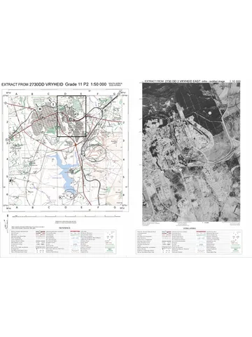
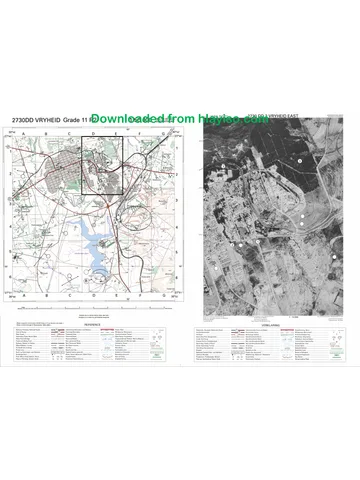
1. An extract from topographical map 2829AC HARRISMITH.
2. Orthophoto map 2829AC 3 HARRISMITH.
3. NOTE: The resource material must be collected by the schools for their
own use.
INSTRUCTIONS AND INFORMATION
1. Write your name in the space provided on the cover page.
2. Answer ALL the questions in the spaces provided in this question paper.
3. You are supplied with a 1 : 50 000 topographical map 2829AC of
HARRISMITH and an orthophoto map of a part of the mapped area.
4. You must hand the topographical map and the orthophoto map to the
invigilator at the end of this examination session.
5. You must use the blank page at the back of this question paper for all rough
work and calculations. Do NOT detach this page from the question paper.
6. Show ALL calculations and formulae where applicable. Marks will be
allocated for this.
7. You may use a non-programmable calculator.
8. The following English terms and their Afrikaans translations are shown on the
topographical map:
ENGLISH AFRIKAANS
Diggings Uitgrawings
Caravan park Karavaanpark
Sewage works Rioolwerke
Golf course Gholfbaan
Wetland Vlei
Copyright reserved Please turn over
Geography/P2 3 DBE/2013
NSC – Grade 11 Exemplar
QUESTION 1: MULTIPLE-CHOICE QUESTIONS
The questions below are based on the 1 : 50 000 topographical map 2829AC
HARRISMITH, as well as the orthophoto map of a part of the mapped area. Various
options are provided as possible answers to the following questions. Choose the
answer and write only the letter (A–D) in the block next to each question.
1.1 The main agricultural activity around Harrismith is ...
A crop farming.
B fruit farming.
C cattle farming.
D chicken farming.
1.2 The recreational feature marked 1 on the orthophoto map is a …
A park.
B nature reserve.
C golf course.
D plantation.
1.3 Which town is approximately 60 km from Harrismith?
A Van Reenen
B Warden
C Witsieshoek
D Kestell
1.4 The Sterkfontein Dam is to the … of the town of Harrismith.
A south-west
B south-east
C south
D west
1.5 The map index to the south of 2829AC is …
A 2828DB.
B 2829CA.
C 2828BD.
D 2829CB.
1.6 The river in block C2 on the topographical map flows in a ... direction.
A south-easterly
B north-easterly
C southerly
D north-westerly
Copyright reserved Please turn over
Geography/P2 4 DBE/2013
NSC – Grade 11 Exemplar
1.7 The scale of the orthophoto map is … times larger than the scale of the
topographical map.
A 5
B 10
C 20
D 40
1.8 The road on the topographical map that links Harrismith to Warden and Van
Reenen is a/an … road.
A secondary
B main
C arterial
D national
1.9 11 on the orthophoto map is a/an …
A recreational area.
B residential zone (suburb).
C industrial area.
D cultivated land.
1.10 The feature labelled E on the topographical map is (a) …
A dry pan.
B dry lake.
C marsh and vlei.
D non-perennial river.
(10 x 2) [20]
QUESTION 2: MAP CALCULATIONS
2.1 Harrismith holds an annual marathon that involves contestants running via
Platberg. Study both the photograph of Platberg below and the area covered
by blocks A/B10, 11, 12 and 13 on the topographical map before answering
the questions that follow.
Copyright reserved Please turn over
Geography/P2 5 DBE/2013
NSC – Grade 11 Exemplar
2.1.1 Identify the landform named Platberg.
______________________________________________________
(1 x 1) (1)
2.1.2 Identify the shape of the slope that the contestants will be running up
between points C and D (blocks A/B10) on the topographical map.
Explain your answer with reference to the contour lines on the map.
Slope
______________________________________________________
Explanation
______________________________________________________
______________________________________________________
(2 x 1) (2)
2.1.3 Calculate the average gradient of the slope between spot height
1797 and spot height 2263 in block A10 on the topographical map.
Show ALL calculations.
______________________________________________________
______________________________________________________
______________________________________________________
______________________________________________________
______________________________________________________
______________________________________________________
______________________________________________________
(6 x 1) (6)
2.2 Calculate the area of land covered by the orthophoto map (indicated in red on
the topographic map) in km2. Show ALL calculations.
______________________________________________________________
______________________________________________________________
______________________________________________________________
______________________________________________________________
______________________________________________________________
______________________________________________________________
______________________________________________________________
______________________________________________________________
(5 x 1) (5)
Copyright reserved Please turn over
Geography/P2 6 DBE/2013
NSC – Grade 11 Exemplar
2.3 Refer to the feature labelled Blokhuis (4) on the orthophoto map.
Draw a cross section of the feature from 2 to 3 on the axes below.
1 720
1 710
1 700
1 cm to 10 m
1 690
1 680
1 670
1 660
1 650
1 : 10 000
(12 x ½) (6)
[20]
QUESTION 3: APPLICATION AND INTERPRETATION
3.1 Name TWO ways in which the residents of Harrismith and its surrounding
area can benefit from the Sterkfontein Dam.
______________________________________________________________
______________________________________________________________
(2 x 2) (4)
3.2 Refer to Nuwejaarspruit in block G2 on the topographical map. Is this a
perennial or non-perennial river? Give ONE reason for your answer.
Type of river
______________________________________________________________
Reason
______________________________________________________________
(2 x 2) (4)
3.3 Harrismith is a very old town. Support this statement with ONE piece of
evidence from the map.
______________________________________________________________
______________________________________________________________
(1 x 2) (2)
Copyright reserved Please turn over
Geography/P2 7 DBE/2013
NSC – Grade 11 Exemplar
3.4 Refer to the dominant/main primary activity practised in blocks H1 and H2.
3.4.1 Identify the dominant/main primary activity referred to above.
______________________________________________________
(1 x 2) (2)
3.4.2 Explain how the environment is likely to be affected by this activity
named in QUESTION 3.4.1 in a negative way.
______________________________________________________
______________________________________________________
(1 x 2) (2)
3.4.3 What can the local government of Harrismith do to beautify the area
affected by the primary activity named in QUESTION 3.4.1?
______________________________________________________
______________________________________________________
(1 x 2) (2)
3.4.4 Name ONE other primary activity visible on the topographic map.
Also give the block reference number of the primary activity that you
have named.
Primary activity
______________________________________________________
Block reference number
______________________________________________________
(2 x 2) (4)
3.4.5 Named any ONE tertiary activity visible on the topographic map.
Also give the block reference number of the tertiary activity that you
have named.
Tertiary activity
______________________________________________________
Block reference number
______________________________________________________
(2 x 2) (4)
Copyright reserved Please turn over
Geography/P2 8 DBE/2013
NSC – Grade 11 Exemplar
3.5 Refer to the N3.
3.5.1 Why does the N3 NOT pass through Harrismith?
______________________________________________________
______________________________________________________
(1 x 2) (2)
3.5.2 State ONE disadvantage for businesses of the N3 not passing
through Harrismith.
______________________________________________________
______________________________________________________
(1 x 2) (2)
3.6 Refer to 3 on the orthophoto map.
3.6.1 Which slope element/form is found at 3?
______________________________________________________
(1 x 2) (2)
3.6.2 Which slope element/form is absent on the slope between 3 and 4?
______________________________________________________
(1 x 2) (2)
3.7 Refer to the orthophoto map.
3.7.1 What type of photograph is used to compile an orthophoto map?
______________________________________________________
(1 x 2) (2)
3.7.2 Give ONE advantage of using an orthophoto map.
______________________________________________________
(1 x 2) (2)
3.7.3 Was the photograph used to compile the orthophoto map taken
before or after midday (12:00). Give ONE reason for your answer.
Time
______________________________________________________
Reason
______________________________________________________
(2 x 2) (4)
[40]
Copyright reserved Please turn over
Geography/P2 9 DBE/2013
NSC – Grade 11 Exemplar
QUESTION 4: GEOGRAPHICAL INFORMATION SYSTEMS (GIS)
4.1 Study the map below (FIGURE 4.1) which shows the path of the tornado that
tore through Harrismith a few years ago. Many data layers were used to draw
this map.
HARRISMITH
[Source: Goliger and Van Wyk]
FIGURE 4.1
4.1.1 Define the term data layering.
______________________________________________________
______________________________________________________
(1 x 2) (2)
4.1.2 Name ONE data layer visible on the map (FIGURE 4.1).
______________________________________________________
(1 x 2) (2)
4.2 Name the vehicle used to capture remote pictures of the Earth from outer
space.
______________________________________________________________
(1 x 2) (2)
Copyright reserved Please turn over
Geography/P2 10 DBE/2013
NSC – Grade 11 Exemplar
4.3 Study the photo (FIGURE 4.3) of the N3 that bypasses Harrismith and
connects Durban and Johannesburg.
[Source: Google]
FIGURE 4.3
4.3.1 Differentiate between spatial data and attribute data.
______________________________________________________
______________________________________________________
______________________________________________________
______________________________________________________
(2 x 2) (4)
4.3.2 What type of spatial object (point, line or polygon) is the road?
______________________________________________________
(1 x 2) (2)
4.3.3 Name ONE attribute that can be captured for the N3.
______________________________________________________
(1 x 3) (3)
4.4 Explain how GIS could assist with the placement of a McDonalds restaurant
in/close to the town of Harrismith.
_______________________________________________________________
_______________________________________________________________
_______________________________________________________________
_______________________________________________________________
(2 x 2) (4)
Copyright reserved
Geography/P2 11 DBE/2013
NSC – Grade 11 Exemplar
4.5 Does the orthophoto map of Harrismith display a high or a low resolution? Give
ONE reason for your answer.
Resolution
_______________________________________________________________
Reason
_______________________________________________________________
(2 x 2) (4)
[20]
TOTAL: 100
Copyright reserved
Geography/P2 DBE/2013
NSC – Grade 11 Exemplar
ROUGHWORK AND CALCULATIONS
Copyright reserved
Study this subject
Recommended for this subject
Addendum
Geography Grade 11 P2 2020 Addendum (Eng)
Question paper
Geography Grade 11 P2 Eastern Cape November 2022 QP (Eng)
Question paper
Geography Grade 11 P2 Eastern Cape November 2018 QP (Eng)
Memorandum
Geography Grade 11 P2 Eastern Cape November 2025 Memo (Eng)
Memorandum
Geography Grade 11 P2 Eastern Cape November 2022 Memo (Eng)
Addendum
Geography Grade 11 P2 Eastern Cape November 2020 Addendum
More from Grade 11 Geography
Memorandum
Geography Grade 11 P1 Eastern Cape November 2025 Memo (Eng)
Question paper and memo
Geography Grade 11 Free State March Test 2025 Paper & Memo
Memorandum
Geography Grade 11 P1 Eastern Cape November 2024 Memo (Afr)
Memorandum
Geography Grade 11 P1 Eastern Cape November 2023 Memo (Eng)
Question paper
Geography Grade 11 Paper 2 MAPS 2023 Question Paper
Question paper